In the South of the Province of Jilin the wide Songliao Plains extend towards the City of Siping, and
industrial and railway city along the South-Manchurian Railway. In the Vicinity of Siping lies peaceful Yehe Village, the historic ethnic Home of the Manchu's, one of the foremost of Jilin's 49 Ethnic Minorities. Yehe is a place of natural beauty, somewhat of a tourist destination and the host of many Manchu Cultural Events. At another location, more to the Northwest in Yitong County is an even larger community of Manchu's, the Yitong Manchu Autonomous County of Jilin Province. Yitong County is also famed for its volcanic landscapes and peculiar Yitong Volcanic Group consisting of 16 seperate volcanoes. The Dagu Shan with its rockeries, moonscapes, hot aquifers and springs is a local tourist attraction.
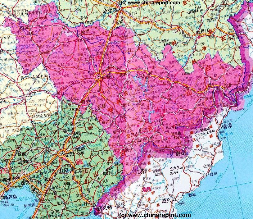
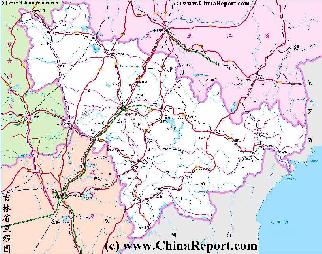
This Geographic Map gives an overview of Jilin Province of North-Eastern China (PRC). The Map includes border areas of neighboring Inner Mongolia Autonomous Region in The West, HeilongJiang Province of China in the North, a narrow strip of Primorsky Krai (Maritime Province) of the Russian Federation in the North-East, the North-Korean Border (D.P.R.K.) to the East and South-East and the border of Liaoning Province to the South-West.
Jilin Province measures roughly 750 kilometers from East to West and 600 kilometers from North to South.
The Highest Points in Jilin Province are generally found in the South-East of the Province from where heights of Changbai Shan gradually decline through the Jidong Hilly Lands towards the North-West.
Central to Life in Jilin Province are the Songliao Plains in which lie the Capital City of Changchun with its 3 million plus citizens and the nearby City of Jilin with 1.3 million inhabitants. The Plains continue south to Siping and North to Songyuan, both cities with large Industries, multiple railway connections and millions of citizens.
Skiing and Winter Sports take place at the Songhua Lake with its Resorts of Songhua Hu and BeidaHu Skiing Areas. All other parts of the province, especially the Eastern Parts of Jilin Province should be considered remote consisting of mountainous terrain, wooded hills and small agricultural villages. Although connections have been markedly improved since the early 1990's and Yanbian now has YanJiChaoYangGuan Airport, travel east beyond Dunhua is tedious and consist of Bus-rides beyond BaiHe'.
Introduction to Jilin Province of China Overview Map 1A - Geographic Map
Compare Maps for better Comprehension. Click through for more Information on each Location & Subject !
The Yanbian Korean Autonomous Prefecture (Yanbian ChaoXianZu) with its bilingual Capital at Yanji City is best reached by Train from Changchun, via Jilin, JiaoHe', Dunhua and Antu. Established in 1952 AD and upgraded to Autonomous Prefecture in 1955 AD, the Yanbian Prefecture forms the North-Eastern Most and least populated section of the Province, bordering directly on the Nations of Russia (Primorsky Krai) and North-Korea.
The Western Half of Jilin Province has completely different sights and spots of interest for visiting Tourists. Most noteworthy is the vicinity of the small City of Da'an on the border of HeilongJiang Province. With nearby Chagan Lake, which ranks among the 10 largest fresh water lakes in the Peoples Republic of China and further to the North-West the Moon Lake Reservoir, this extensive region consists of various lakes attracting a variety of rare migratory birds. Interestingly, the Changan and Moon Lake are vital to the a healthy eco-system in these remote parts and the adjacent ZhaLong Nature Reserve, covering a part of HeilongJiang Province. The rare natural beauty, vast lakes and abundant birds and wildlife have recently given birth to a first Chinese version of eco-tourism, as more and more Chinese Native Citizens visit in the warmer months to enjoy the wild natural beauties and rare species. Others come especially to visit the Mongolian Ethnic Minority Communities in the area, or look for the rare Xibe People.
Last but not Least, in the far south-eastern corner of the Province, the entire Region surrounding the small City of Ji'An on the North Korean Border was declared a UNESCO World Cultural Heritage Site in 1997 AD. Out of the way of most mass tourism routes, the abundant Koguryo (Goguryeo kingdom) relics in the area are still under study or as yet unrecorded and unpreserved.
BeiDaHu Ski Area
Songhua
Hu Ski
Area
Bohai
Sea
Xiao River
Further South and slightly more Westward lies the largest Wildlife Reserve in China, the Changbai Shan (Everwhite Mountains) National Reserve. The Chanbai Shan reserve is only open between May and September due to the harsh winter climates, but offers a stunning variety of natural resources and beauty. Jewels of the Park include the Heaven Lake Volcanic Lake (on the Korean Border) of 2194 Meters in Height, a small volcanic hot-spring, endless forest trails and the spectacular Changbai Shan Canyon and waterfalls. BaiYun Shan is the Highest Peak in the Park with 2691 Meters.
ZhaLong Nature Reserve
Songhua River
Gaya River
Kerqin
Grasslands
Songnan
Plain
In the far West of Jilin the Kerqin Grasslands announce the territories of Inner Mongolia (AR).and the Manchurian Plains. This vast area of grasslands is popular for cattle raising, sheep herding and dairy farming and offers another completely different natural scenery within the Province.
The Center of Jilin Province :
At the very center of the Province of Jilin lie the wide Songliao Plains, in the middle of which the Capital City of Changchun with its heavy industry. The Plains continue soutward to Siping City and the border of Liaoning Province.
Discover China in all aspects with ChinaTravel2.0 ! Culture, Food, History, ethnic minorities and off the beaten path locations and sites to visit - China Travel 2.0 has it all and thus offers and brandnew eco-oriented way of travel within the Peoples Republic.
Join DrBen.net & AsiaReport.com exclusive partner for your Travels in China and join a learning experience of your choice !!
A Schematic overview Map of Jilin Province entire delineating provincial borders and parts of neighboring Inner Mongolia AR in the West, HeilongJiang Province in the North, the Russian Primorsky Krai Maritime Province to the East, North Korea in the East and South-East and finally Liaoning Province in the South-West. Map and description include Main Cities and Towns (shown by size), Main Monuments & Landmarks of Jilin Province, the Yanbian Korean Autonomous Prefecture on the borders with Russia and North Korea, Changbai Shan Naturese Reserve, Songhua Lake, Main Mountains (with Height), major highways, provincial railroads and main railroad-stations, and main waterways & rivers. This Map further provides links to on site photos and information on the Cities and Main Monuments.