Apart from the Shanhai Pass of the Great Wall itself, the defenses of the vital pass include two additional sections. Firstly there is the Old Dragon's Head and the attached Great Wall of China (the only part of the Great Wall that meets the sea) closing the gap between Shanhai Guan Pass Gate and the Sea in the East, and secondly there are the Jiaoshan Mountain due west of the City of Qinhuangdao, which are the first sections of the Great Wall of China to climb from the north China plain into mountains of Hebei Province).
Arranged together as they are, the Shanhai Pass and fortifications themselves are erected as a barrier between the North-Eastern (Dongbei) plains (of Manchuria) and the North China (Huaibei) plain in which the City of Beijing is situated. To complete the defenses on an even larger scale, the Great Wall built in the Ming Dynasty Era (1368 A.D. - 1644 A.D.) leads from Shanhai Pass eatward to Mount Yan (Yan Shan), where it splits into two parts. The Southern part is considered as the Main Body of the Great Wall of China and leads south and west past Qian'An City, Zhunhua City into Beijing City Province where it continues to Miyun and Huairou. The Northern part of the split at Yan Mountain is considered an addition as it was only built in the second half of the 15Th Century and was not as solid and continuous as the
- Shanhai Pass (Shanhai Guan) First Gate Under Heaven i/t East-
Great Wall of China in Hebei Province
ChinaReport.comat
The Great Song Era historian Ouyang Xiu (1007 AD - 1072 AD) once wrote on the Matter of the continuous raids by Nomadic Tribes against Han Chinese Communities; "Our Chinese Infantry Men are at their Best (in war) in obstructing Passes, while the Barbarian Cavalry is at its Best on the Flat land. Therefor, let us resolutely stand guard on the Passes, and let us not drive after them in pursuit or in order to get rid of them. At the Time when they come, we should close and defend the passes so that they cannot enter (our lands). When they leave we should close strategic passes (as well) so they cannot return".
And so it was done. Although in the Song Era only modest defenses on scattered passes on the Northern borders had been erected, these had been neglected during the Tang Dynasty Era when the Chinese realm extended far beyond the Wall. The neglect of the Great Wall had once more exposed China to a Foreign Threat, culminating in a full Invasion by the Mongolians, setting up the Yuan Dynasty (1276 A.D. - 1368 A.D.) in China. Therefor, after the Foreigners had been expelled, during the ensuing Ming Era the Chinese were determined to not repeat their mistake of neglecting the defenses. The Great Wall would be repaired and finally become one unified defensive system. And not only that.
After the Mongolian Tribes had regrouped and recovered from their defeat in China, they returned to linger along the outer borders once more becoming a threat. As a result the defenses of the Great Wall grew even stronger and more and more sections and layers were added. The wall grew until the year 1644 A.D. when the Shanhai Guan pass and China entire fell to Qing Dynasty, rendering it useless to the Nation.
During most of the Ming Dynasty Era, in the years between 1368 A.D. and roughly the ending decennium of the 16Th Century, things were mostly quiet around the Shanhai Fortress and the Great Wall at the Pass. No important and ground shifting historic events occurred at Shanhai Pass, mostly due to its great defenses, and also because Chinese had extended their rule beyond the Great Wall, buying the favors of neighboring rulers with trade, favors, Princesses of the Royal Family, empty titles and other proven methods. Furthermore, the main threat to the Great Wall of China in the earliest periods of the Ming Era came from the reasserting Mongolians, the old arch enemy, who's troops generally attacked more to the West, at Beijing and beyond.
The Great Wall north of Beijing, the Wall at "Heaven's Gate (Zhangjiakou; Mongolian: Kalgan)" in north-west Hebei Province, along the length in Shanxi Province and even farther away along the Ordos Desert in Shaanxi Province, Ningxia (Hui Autonomous Region) and Gansu Province is where the early clashes between the returning Mongolians and the Ming Armies took place. However, centuries later, at the end of the 16Th Century the Manchurians of North-East China arose, ultimately to organize themselves into a seperate Kingdom (The Qing), which could rival the Ming Emperor of China in Beijing for ultimate supremacy. Only in the very end in 1644 A.D. it was showtime for the defenders of the Shanhai Pass and Fortress.
Shanhai Guan Guan Pass o/t Great Wall depicted on Stamp valued 20 Fen.
A Full Google Earth Supported Map of ShanhaiGuan Fortress City by Google.com.
SHANHAI PASS AND GREAT WALL IN THE SINO-JAPANESE WAR:
After lenghty battles had already been fought out between Japanese Armies and the Kuomintang and Communist Party Volunteers during 1932 AD, in 1933 AD the Japanese Army, bent on including the Chinese Territory of Rehe (parts of Hebei, Liaoning and Inner Mongolia AR today), attacked the Shanhai (Guan) Pass. The attack was initially repelled by the Chinese Garrison ready on the Great Wall and inside the Fortress, however eventually the Japanese beat them
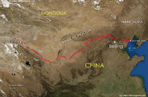
China Report - Map of the Great Wall during the Ming Dynasty
Satellite image of China and North-East Asia, with a super-imposed schematic Map of the location and Path of the Great Wall as constructed during the Reign of the Ming Dynasty. Included for reference are City names, geographical features of landscape, Names and locations of Passes on the Great Wall of China.
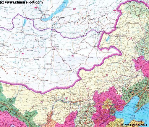
Helpful Geographic Map of Inner-Mongolia showing the larger geographic relations in the Region. Inner Mongolia surrounds Beijing City, but the city lies protected behind a ring of mountains. Across the mountains lies the Wall
Returning to the Great Wall of Shanhai Pass on the coast: The Great Wall of China at Shanhai Pass (Shanhai Guan) is one of the most famous Gates on the Great Wall, for many reasons but most likely for the Chinese-Manchu showdown that occured at the Gate of the Pass when the armies of Nuerhachi arrived bent on Invasion. That would be at the very end of the Ming Era, however.
It has also been called the museum of the construction of the Great Wall because of the great variety found in the Ming Dynasty Era defenses of this section. There are the Wall and the Sea, the Gate, Gate Fortress and City, and then there are the mountains.
Although belonging to the same large scale defensive works inside the narrow gap between the Sea and the Mountains, each section lies several kilometers from the other, and each section has distinct caracteristics, making all of them quite different and wortwhile to visit seperately. This page and chapter deals exclusively with the Shanhai Pass (Shanhai Guan) and the Shanhai Pass Gate Fortress and City.
main body, but still it reaches a fenomenal length. The Northern Wall curves north into Shuizong County of Huludao (葫芦岛) Prefecture in Liaoning Province as the Jiumenkou Great Wall. From there the Wall follows along the border with Inner-Mongolia Autonomous Region past Yixian, Haicheng, Liaoyang and Shenyang. North of Shenyang the "Northern Wall" continues heading towards the Korean Peninsula where it ends today at the Tiger Mountain (Hu Shan) just north of the City of Dandong on the North Korean border. The original Wall however, reached even further, into North Korea to include all of the City of Pyongyang - a Chinese enclave and protectorate until the dying years of the Qing Dynasty (1368 A.D. - 1644 A.D.). In recent years many ruins been found indicating further walls in and near Korea.
Altogether this lenghty northern wall was equal in importance to the others and was designated the first of the 9 defense area's that administered the border regions along the Great Wall. It served to protect the extensive Chinese enclave which had come to extend along the coastal corridor and included the Liaodong peninsula as well as a large swath of what today is North Korea (D.P.R.K.).
Find DrBen and ChinaReport on Facebook with the latest from www.drben.net.
Four days later on March 16Th the Japanese re-attacked at Luowenyu (in Tangshan Prefecture), attempting to seize the strategic Sanchakou Hill. Being held back, on the 17Th the Japanese Air Force arrived and a full offensive combining air assaults and artillery attacks followed. Again the Chinese strategy was to let the Japanese come in close so they would lose their artillery and air support. Hand to hand combat on and around the Wall ensued throughout the day until darkness fell.
The next day on the 18Th the scenes repeated themselves.
In the night however, the Chinese Armies again counter attacked. This time Chinese forces surrounded the Japanese Camp-sites and annihilated them in a final lenghty battle which involved lots of vicious hand to hand combat.
So, the Chinese side won. In fact, it advanced 10 kilometers in the next few days, gaining back Chinese Territory. A new Treaty. The Tanggu Treaty, with the Central Government however effectively ended all battles, tacidly approving of Japanese control of Rehe and other parts of North China.
The Shanhai Pass is considered the North-Eastern Terminus of the Great Wall but not its final Eastern Endpoint. The Shanhai Pass lies confronting open ground between the Bohai Bay of the Yellow Sea in the East and the Mountains of Hebei Province in the West. The Fortress City of Shanhai Guan still exists today and stands smack in the middle of the narrow passage between the Sea and Mountains blocking a major route out of Beijing, the National Capital, and Liaoning Province in the former Manchurian Territories. The distance to the mountains lying behind the fortress is only a bit more than a 3 kilometers (officially 10 Li) and the distance to the sea is about a 4 kilometer (though officialy only 8 Li).
Altogether encompassing an impressive suface area the Fortress City was Walled and further surrounded by a deep moat. It lay at the center and core of the defenses, and was home to a large military garrisson as well as a considerable civilian population. The City Fortress served as the main military headquarters responsible for the entire north-eastern section of the Great Wall of China and in the heydays of the Ming Dynasty had a garrison of 80.000 Men. Crucial in the defense of the Imperial Capital, as history would prove, the Shanhai Guan citadel was considered one of the
SHANHAI PASS AND 1644 AD - DECEAT AND DEFEAT OF THE GREAT WALL :
Generally speaking the troubles for Shanhai Fortress and Pass started in the year 1619 AD, although even earlier the Manchu Nobelman Nuerhachi had started building his Empire and had arrived as a serious threat along the borders in the North and East.
The year 1619 however, turned the threat in Manchuria much more accute after a Han Chinese expedition into the north-east aimed to limit Nuerhachi's rise failed miserably. Not only did it served to further unite the peoples of the lands outside the Wall, many Mongolian Tribes joined under the Manchu Flag, in the end it also ended in a striking defeat which left the incomplete Wall of the North-East vulnerable. Soon the Chinese enclaves in Liaodong and Korea found themselves at the mercy of the Manchu and their associated tribes (the Manchu-Tungusic Peoples) and were overrun. The debacle greatly increased the Manchu confidence, as well as their economic and miltary powers. The enemy now had virtually free access to the main body of the Great Wall which included the Shanhai Fortress.
The Rise of the Manchu over the North-East continued with their allegiance with more Mongolian Tribes, which expanded their realm to much of Inner Mongolia (today an Autonomous Region).
Although in a sense, Nuerhachi was the final victor of this building conflict, it was not before the Ming Armies struck back a painful blow. It was a clear sign of the coming cataclism that the next large Battle occured only 80 kilometers from Shanhai Fortress (Shanhai Guan) at another Fortress Town known as Ningyuan (Today: Xingcheng).
Probably in an attempt to probe the Great Wall of China, or at least avoid the strongest point at Shanhai Guan, the united Manchu Armies under personal leadership of Nuerhachi chose to strike at the much smaller Town of Ningyuan. However, they were surprised by an unexpected twists of fate, an event which lay ultimately beyond the influence of Nuerhachi. While the north-eastern King was busy organizing his state into a united and well organized war machine, the Chinese had been in contact with oversea's Western Powers for a considerable period. They had so, overtime, aquired the handy advise of Portugese jesuit scientists, some of whom even held high post at the Imperial Court. Through these contacts, entirely unbeknown to the King Nuerhachi, they had for the first time aquired modern western canon, a technological invention which the Chinese had learned possesed lethal powers.
When the Manchu attacked the Ningyuan Fortress Town in full force they found it well defended by its own garrison and a further contigent of Portugese designed canon. The Canon, imported through the Portugese Lease of Macao (Macau), devastated the enemies ranks, sank the Manchu armies moral and eventually forced them into a temperory retreat. Limping away the Manchu Army found its King Nuerhachi wounded in battle, a wound that led to his death shortly after.
Although the Chinese had fended off the first massive assualt in the Wall, and had even managed to kill their Supreme Leader it did not help turn off the Manchu Tide in the Long run.
Under a new King, Nuerhachi's Son, the young Hong Taijie. Until he reached maturity and would be ready to lead his nation, the Throne was managed under the oversight of Lord Dorgon.
Although the situation remained tense along the border for the entire period, the Manchu would be away for some time, only to return in the disastrous year 1644 AD.
Interestingly, not much after the death of Nuerhachi - King of the North-East, the Ming Chinese Emperor also gave the spirit, leaving the next Battle to a new Generation.
Finally, in the year 1644 AD the end did not come to China and Shanhai Fortress merely through the Military means of Manchu Army. Much more to the point it was the overwhelming and ensuing chaos that suddenly swept the entire Chinese Nation. Already weakened at the heart, the Shanhai Fortress thus found itself confronted by a mighty force, while eroded from within.
The end did not come as a batlle, but rather surpisingly as the result of what many still hold as an act of teachery and deceit. Others however, recognize it as a most noble act which served the Chinese People, eventhough it could not stave off another foreign invasion and rule.
Under editing - Fall of Shanhaiguan, one day Emperor in Beijing.
MILITARY CAMPAIGNS OF THE GREAT KANGXI EMPEROR:
Historic sources tell how in 1682, just shortly after the final annihilation of the last Ming heirs in Southern Yunnan Province of 1682 (They were handed over by the Birmese and subsequently strangled to death), the Kangxi Emperor took his armies out on a huge military expedition in order to show the prowess of his forces to the unruly who might think to rebel, and also to give warning to enemy invaders which had shown up along the northern en western borders of Manchuria.
strongest points in the chain of defenses along the entire wall in China, thus gaining everlasting fame as "The First Pass Under Heaven in the East".
The stronghold seemed untakeable. Yet, in the year 1644 AD the Gate was flung open and the Fortress fell, making it a notorious place along China's Wall. The Fall of the Shanhai Fortress left the city of Beijing dangerously exposed and without defense. Chinese lands were at the mercy of Foreign Invaders. The invasion of Manchu from the North established the Qing Dynasty over China staying in power until the end of the year 1910.
This page was last updated on: May 15, 2017
My Great Web page
The Shanhai Fortress City (Shanhai Guan) is situated in the northern parts of Qinhuangdao City, which itself is sitauted on the coastline of Hebei Province. To get to the Great Wall, first travel to Qinhuangdao. This is possible by Airplane through Qinhuangdao Airport, or by train through the Main Train Station of Qinhuangdao. Once inside the City find your way to the Fortress, the sections of the Great Wall and various associated sites and Monuments. In general: The Laolongtou Fortress and last bit of the Wall are situated on the coast line. The Shanhai Fortress stands in the middle of the pass and makes up its own minor district of the north-eastern parts of Qinhuangdao City. Travel to the north-western outskirts to find your way up the Great Wall climbing into the mountains towards Beijing and ultimately the far West of China.
Distances withing Qinhuangdao City are surpisingly large. It is a miniature sprawl of villages thrown together. Spare your legs in order to explore and see more of the Great Wall of China and other sights. Convenient Travel from your hotel or place of staying within the City to the various sites by taxi or bus is easy.
The Main Entrance from the City to the Jiaoshan Great Wall of China sections is relatively easy to find. In addition, most Taxi Drivers, Bus Drivers, Concierges and locals will be aware of its location and may be able to give directions. In this case, a pen and paper, map or visual explanation may help to distinguish between the Wall and the Fortress.
The main problem with the Jiaoshan sections of the Great Wall however is that their length amounts to much more than first time visitors generally expect. In part this is due to the fact that in the recent past many parts of Jiaoshan were left unrestored. Initially and historically, the main attention went to the Fortress and the Old Dragon's Head section and Fortress at the coast. Recently however, a much larger section has been "officialized" and opened to the public. These "new" sections lie to the north of the initial offical parts. A large section of this "new" wall has been restored, other parts situated more uphill are however refreshingly unrestored, leaving planty of wall to discover and explore for anyone who is interested and willing to do so. To explore of the Great Wall of Jiaoshan, several days will be needed.
Of all the defensive structures that are part of the Great Wall of China inside the Shanhai Pass, the Shanhai Fortress City is by far the largest and thus probably the easiest to find. Travel from the main center of Qinhuangdao, the Haigang Districts due East. Travel along the S048 Provincial highway to pass through Shihezhen, which is situated immediatly north of Qinhuangdao Airport. The Ancient Fortress City of the Great Wall can be found just beyond. The Fortress City is locally know as No. 1 Guanzhen which translates roughly as No. 1 Gate Under Heaven Fortress Town. Follow the signs along the highway and roads. Apart from the main site of No.1 Guanzhen, which is the walled fortress city (Guan Zhen), there is the further Tianxia Diyiguan Scenic Area due East of the Walled City. The name of this site refers to the pass rather than the fortress and involves a small section of restored Wall and not much more.
Exploring the Fortress City is interesting enough all by itself. One can climb the Walls, admire the view and make a walk around the old town district that was the Shanhai Guan of yesteryear. Inside the impressive walls one can browse around endlessly exploring roads and alleyways trying to find traces of the history in the many original buildings. As with all Great Wall of China sites nationwide however, the mass influx of new Chinese tourists has led to a development push of Qinhuangdao as well as all sites related to it.
Unfortunatly and contradictory, this means that the old city district may be slated for whole sale renovation which in China often leads to the destruction of history in an effort to polish the facade.
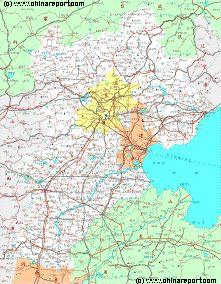
Hebei Province Map 1 - Schematic Map - Large
A schematic overview of North-East China's Hebei Province entire, delineating Provincial Borders and parts of neighboring Shanxi-, LiaoNing- and Shandong Provinces and Inner Mongolia Autonomous Region. The Map clearly the location of Qinhuangdao and gives an overview of the remaining Great Wall sections in the surrounding regions.
Today's Shanhai Pass Fortress, Old Dragon's Head and associated Great Wall of China Sections are considered to rank top among the major travel destinations in north-eastern China. Within fairly easy reach of Beijing, Tangshan City and other major population centers, as well as set near the Beach Resort Town of Beidahe, the Shanhai Pass Great Wal can count on plenty of daily visitors, especialy in the spring and summer months. For some visitors this leads to disappointment.
There is however plenty to see when one arrives more properly informed.
Main Sites:
East Gate (Dong Men) - Firs Gate Under Heaven in the East.
A Full Google Earth Supported Map Overview of All Structures of the Great Wall of China from East to West, by DrBen.Net (c) ChinaReport.com and Google.com.
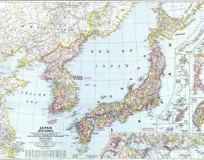
Asia Report - Colonialism - China Coastal Prov., Korea & Japan in 1945 AD
An accurate Geographic Map of the East Asian Coastal Regions of China (Republic), the Korean Peninsula, the Japanese Islands and associated Regions in the Year 1945 AD. At that Time large parts of Manchuria and Inner Mongolia remained under Japanese Occupation as part of the created State of Manchukou, while Korea was actually annexed and to be fully included as a Province of Japan.
Included in this Map are the main cities across the Chinese Coastal Regions, the Korean Peninsula and Islands with their names of 1945 and present day. Marked in Colors for clarity are the various colonial and imperialist Nations.
Included in the Map are Main Cities, Towns and Villages, sections of the Great Wall of China as well as main road connections, railroads, current day sites of tourist interest as well as some of the North Korean ethnic minority villages on the Sino-Korean Border.
Through the records of a Jesuit Priest, the leading court mathematician Ferdinand Verbiest it is known that the expedition left Beijing on the 23rd of March, and chose a route that first took it to the Shanhaiguan Fortress (through which the Qing had also entered to subdue China) - the "First Heavenly Gate in the East". After celebrating his success there and inspecting the Fortress troops, the Imperial Army - 70.000 strong with many more serving in logistic roles- , rode out towards the Liaodong Peninsula, and from there traveled to "Kirin" (Now Jilin City of Jilin Province) in North-East Manchuria (See adjacent Map for Route). Today Jilin City is famous for being situated on the supposedly pittoresque Songhua River, and at the time of the year 1682 A.D. it was good position from which Kangxi could project his military strength towards the Russians which had started to show up in these particular regions and who were by no means welcomed.
Verbiest found great opportunities to learn about China as he was taken along on these expeditions in order to measure all kinds of things along the way, among things in order to make maps. He saw the most magnificent sights and witnessed the largest Chinese Military maneuvers any westerner had ever laid eyes on, but he was the most awestruck and intrigued by the sight of the Great Wall of China. He found it magnificent.
A year after this first grand tour of the Provinces, a similar tour - but of the western parts of Manchuria, would take the Emperor Kangxi, his advisor Verbiest, and another vast army across the Great Wall of China no less than four times, at which time Verbiest is known to have "measured" the Great Wall using some sort of instrument. The measurement came out as being "1037 geometric foot" above the horizon, but given the huge variations found along the length of the Great Wall, it does not mean much.
back suffering heavy casualties. After the taking of the Shanhai Pass in 1933 AD, the Japanese Army could move on to include Rehe, and encircle the strategically important Northern Capital of Beiping (Beijing). Although the battle for Rehe would last 3 months longer, seeing 20.000 Chinese soldiers dead, the Chinese Lines crumbled under the efficiency of the Japanese attacking force.
Next up were the Great Wall of China passes on direct approaches to Beijing in Eastern Rehe. More battles at the Great Wall of Jiumenkou (today in Suizhong County of Huludao (葫芦岛) Prefecture of Liaoning Province) and Jifengkou (Xifengkou) between the Japanese Imperial Army and the 29Th Route Army of the Chinese Communist Party.
Both Xifengkou and Luowenyu (in Hebei province) were vital passes on the road to Beijing and commander Song Zheyuan was responsible for the village of Lingzikou, both passes and the distance to the village of Malanyu (today in Tangshan Prefecture of Hebei Province).
On March 10 and 11 1933 AD bloody hand to hand combat took place on both passes between eager Japanese invaders and equally zealous Chinese Communist Volunteers. Both sides intermixed, hacking away at eachother with broad swords. Meanwhile Japanese artillery and aircraft supporting the infantry attack were unable to intervene. The attack faltered with the Japanese retreating in surprise.
The very next night on March the 11Th, a small Chinese Group challenged the cold night and the falling snow to raid the Japanese soldiers in their own camp. In the early hours of the 12Th of march, the raiding group found a Japanese Artillery camp where the soldiers of the 14Th Group were sound asleep. A deadly mistake of the overconfident Japanese Force.
A battle ensued throughout the night, with both sides sending in reinforcements. In the morning 18 pieces of artillery were destroyed and some 600 Japanese Soldiers lay dead.
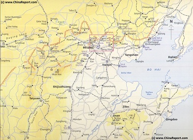
Map - Schematic - Hebei-Beijing-Tianjin Great Wall Locations
A Schematic Map overview of Great Wall locations and sections in Shanxi Province, Hebei Province, Beijing City Province, Tianjin City Province and parts of Liaoning Province. This Schematic Map focusses on the seperate visitable Great Wall of China locations and sections within the depicted regions, and includes as the Main Monuments and Scenic Sites in their vicinity as well. Find the locations of the Great Wall of China in northern Shanxi, the famous fortified "Heaven's Gate" (Kalgan) Fortress in northern Hebei Province, the "First Gate under Heaven in the East and the Terminus of the Inner Layer in the East (Laolongtou) and several often overlooked sites in Liaoning Province.