This page was last updated on: November 17, 2008
Visitable Great Wall of China locations :
54511
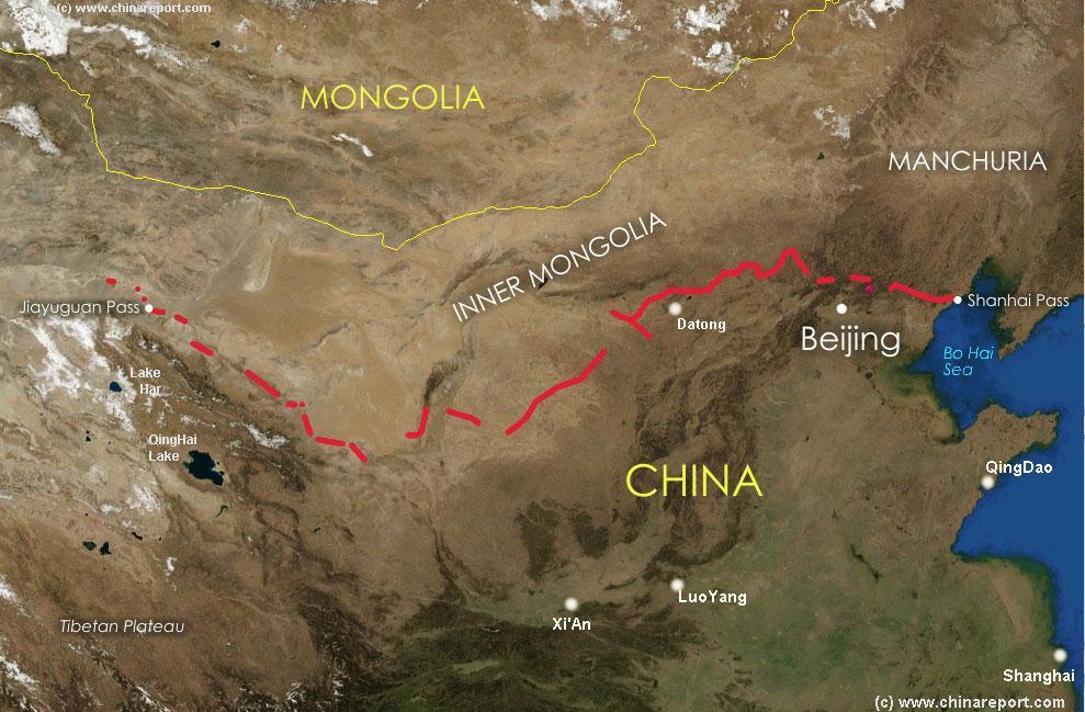
This Satellite Image clearly depicts China and East-Asia. Super-imposed is a schematic of the location and path of the Great Wall of China as constructed during the reign of the Ming Dynasty (1368 AD - 1644 AD). Countries and area's included are Mongolia, Inner Mongolia and parts of North-, Eastern- and Western China. For your reference the Map further includes the location of National Borders, major Cities with their Provinces and the location of passes on the Great Wall. JiaYuguan Fortress at the Pass of the same name is considered the Ultimate Terminus of the Great Wall in Gansu Province in the West. There is However more to the West of JiaYuGuan. The Path of the Great Wall of the Ming Dynasty tracks further by way of Fire Beacons all the way to Dunhuang. Some 120 Kilometers North-West of Dunhuang lies the Jade Gate Pass (YuMen), today the official End of the Great Wall of China of the Tang Dynasty. Shanhai Pass, the most Eastern Pass on the Wall where it meets the Bohai Sea is also
The China Report
Satellite Image Schematic Map of Great Wall of China location explained
JiaYuGuan - No.1 Beacon Tower (Ming Dynasty Era) TaoLai Gorge, Gansu Province (Outer Layer)
JiaYuGuan - Shi Guan Pass - Extended Arm Great Wall, Gansu Province (Outer Layer)
JiYunGuan Pass (Badaling)
Sun Gate Pass- Fortress and Starting Point o/t Southern Route of the Silk Road
YuMen Guan -->
Pass
Dunhuang
PianGuan
Pass
North
South
East
West
A detailed Satellite Image based Map of the Gobi Desert of North-China and Mongolia
Xi'An, Shaanxi
ChinaReport.com at
To Main Menu of All Websites at DrBen.Net
Go to www.drben.net webring
LuoYang, Henan
Beijing, Hebei
Chengde, Hebei
YanMenGuan
Pass
Datong, Shanxi
Ningwu Guan
Pass
Tower
on the West End of the Great Wall of China at Jia Yu Guan Pass, Jiayuguan, China
Tower on the West End of the Great Wall of China at Jia Yu Guan Pass, Jiayuguan Fortress, West China Photographic Print
Su, Keren
HuangYa Guan
Pass (Yellow Cliff)
Lanzhou, Gansu
Lanzhou
The Great
Wall of China Stretching over the Mountains, Built in the Ming Dynasty
(1368-1644)
The Great Wall of China built in the Ming Dynasty (1368-1644) stretching over Mountains. Giclee Print
Suzhou
QingDao,Shandong
Suzhou, Jiangsu
Shanghai, Zhejiang
Dunhuang, Gansu
Gobi Desert
Rhe Great Wall of China full documentary !
Need we Say More? Great DVD on the even Greater Wall of China.
Buy it at Movie Universe - Click Here
Ulanbataar, Mongolia
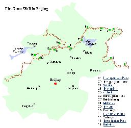
A map of a Section of the Northern Half of Beijing Municipality with locations of the Great Wall of China near Beijing
Click to View Satellite Image of Greater Beijing Area
Kelan Pass (Or Helan), Ningxia Province
PiYanGuan Pass - Interruption of Wall by Yellow River
Maps.com: The Place for Maps Online
Ngoring Hu
Gyaring
Hu
TaiYuan, Shanxi
Ningwu Guan (Inner Layer)
YanMen Guan (Inner Layer)
PingXing Guan (Inner Layer)
Pian Guan (Inner Layer)
Badaling Pass & JiYunGuan Fortress, Hebei (Outer Layer)
??? Pass to Inner Mongolia (Outer Layer)
ShanHai Fortress, Hebei - "First Pass under Heaven " (Outer Layer)
JiaYuGuan Fortress, Gansu Province (Outer Layer)
SimaTai Great Wall of China, Hebei (Outer Layer)
LongQuan Guan (Inner Layer)
PingXin Guan
Pass
LongQuan Guan
Pass
Hexi
   Corridor
JiaYuGuan (Gansu Province)
Jade Gate Pass- First Pass in the West , End of Tang Dynasty Great Wall of China - Start North Route Silk o/t Road
Lonely Planet Shop
know as "The First Pass under Heaven". This end location at the sea-side is known as Old Dragon's Head. The entire lenght of the Ming Dynasty Great Wall (multiple-layers) has been estimated to be around 8000 miles. The Great Wall cannot be seen from Space.
Click to go to Silk Road Map 2 !
China Report - Map of the Ancient Silk Road during the Han Dynasty & Roman Age 1
A Schematic Map depicting other details along the Full Length and main pathways of the Ancient Silk Road during the Han Dynasty Period (206 BC - 221 AD).
As seen from China the Silk Road extends due Westward from Chang'An (Xian) the Han & (later) Tang Dynasty Capital. The Yellow River is crossed at Lanzhou, after which Dunhuang is the Last Station. This Map depicts the Lost Civilizations of Loulan and Hotan, as well as the south route and north route of the Silk Road coming together at Dunhuang in current day Gansu Province of China.
China Maps
China Online Sources
China Offline Sources
China Online Store
China Photo Galleries
Historic Maps
Art & Culture
History
DrBen.Net Home
China Provinces /Home
DrBen.Net Partners
China
Asia Countries /Home
Asia
China Report Club
Blog
Chat
Forum
Provinces Maps
China Politics
China News
City + Site Maps
Below is an incomplete listing of Great Wall of China locations open to the General Public as historical and cultural treasure and Tourist Attraction.
Explore the Great Wall through 100's of Photo's and growing background information on each location and section of it's totalled 8000 Miles. From the Eastern Bohai Sea to Beijing, from Shanxi Province to Shaanxi Province, and then via Ningxia Hui Autonomous Region and the Gobi Desert of Inner Mongolia to wind up in Gansu Province in the far West of China, near Dunhuang at the edge of the Taklamakan Desert.
Browse the growing list of Photo Virtual Tours and Reports on the Great Wall of China.
YuMen - Jade Gate & Toll House
Discover the East Side of Dunhuang City !!!
Dating from the Han Dynasty Era, the Jade Gate - Yu Men has been part of Dunhuang and it's History for 2000 years. Head far out into the Taklamakan Desert, a 102 Kilometers to the North-West, to visit the Jade Gate Toll-House at the Cang River. The Jade Gate marks the beginning of the North Route of the Silk Road around the Taklamakan Desert leading through Turpan Oasis eventually to end up at Kashgar and is considered to be the First Gate Under Heaven in the West on the Great Wall of China.
Visit the Famous First Gate under Heaven !
Sun Gate - Yang Guan Pass
Visit the beginnings of the Silk Road South Route and look out on the endless Taklamakan Desert !
The Beacon and Fortress of YangGuan, the Sun Gate are the counterparts of the Jade Gate (YuMen). Both together marked the "Mouth of China" , the western end of the Hexi Corridor, a strategic mountain route leading directly east and down into the fertile Chinese Heartlands. During the Han Dynasty the Great Wall of China extended as far West as these two points which are located due West of Dunhuang looking out on the Sands and Barren Lands of the Taklamakan Desert. Beyond Sun Gate lay the Silk Road South Route, for which the Fortress provided protection and the Beacon was a guiding point.
The Sun Gate Fortress & Beacon - Beginning o/t Silk Road South Path !
Badaling in the Snow
Great Wall at Badaling in Winter
A foggy but quite unique introduction to The Great Wall of China at its point nearest Beijing, JuYongGuan Pass. The world cultural heritage site of Badaling is the place President Nixon visited on his historic visit and the most popular Great Wall tourist destination of Beijing City after the Palace Museum or Forbidden City.Built in a mountainpass giving access to the North China plain the Badaling Great Wall section was the location that saw the Invasion of the Mongols that would lead to the Fall of the Capital Beijing and enter China into a hated Era of Foreign Rule. Badaling Section gives the visitor a fairly good example of the what the Great Wall was built for and how challenging its defensive works were.
Visit the beginnings of the Silk Road South Route and look out on the endless Taklamakan Desert !
Great Wall at Mutianyu
Great Wall at Simatai Tour
The finest and most spectacular Great Wall of China location in Hebei Province near Beijing is the one nearby Gubeikou Town near the MiYun Reservoir. This location, which connects through to JinShanLing Great Wall to the West, is also the farthest site from Beijing, at a distance of some 120 kilometers due North-East of the Big City. Simatai Great Wall Section has 35 watchtowers in various states of disrepair, the most interesting of which are dotted along a huge and steep granite cliff, making for Great Views and a tough hike.
Just 60 kilometers from the Center of Beijing stands the Ming Dynasty Era section of the Great Wall of China at Mutianyu. This now restored section of Wall is the connecting piece, sitting on mountain tops between the JuYongGuan pass and Fortress (Badaling) in the West and the next Sections to the East, JinshanLing and then Simatai. Part of the Ming Dynasty enhanced defenses of Beijing, Mutianyu Pass was established as late as in the Year 1404 AD , was improved in 1568 AD and is well-preserved.
Click to Enjoy a Walk on The Simatai Great Wall
Take a long Walk at The Mutianyu Wall
Head East out of Beijing to a Mutianyu
The Great Wall on a Steep Cliff near Beijing !
In the East near Beijing, the Great Wall of China can be visited at multiple locations. The Main Site is the one closest to the City at Badaling. Badaling is currently reachable by subway, train, bus and ofcourse Cab and so is often crowded out. The more distant locations, which MutianYu and Simatai are the other popular locations which are reachable by organized tourbus, or your own transport. There are even more Great Wall of China locations visitable near Beijing. JinshanLing Section connects to Simatai and in the Future more on the Great Wall of China at Yellow Cliff Pass, located roughly halfway between TianJin and Beijing.
Of the Locations near Beijing, the Badaling Section and nearby Fortress JuYong Guan are of the most historic importance. It was at Badaling in the year 1225 AD, that the Mongols managed to break through the Defenses of the Great Wall, capturing the nearby Capital City of the Jin Dynasty and ending resistance in North China. Within a few years they went on to conquer the entire Chinese Empire Ruling it as hated Foreign Invaders for over a 100 years.
In the West near Dunhuang, the Great Wall of China terminates in the remnants of the Han Dynasty established Great Wall in these far western regions. In the Past, the Han Dynasty and Tang Dynasty Great Wall extended as far West as Lop Nur. Currently a part of Xinjiang-Uygur Autonomous Region and located well within the Territory of the Taklamakan Desert, Lop Nur is now a dried out Salt Lake, but in history it's Western Most Point near the outflow of the Tarim River was the location of a fortified city which was abundant in fish from the lake and rich in agricultural produce. Today the Great Wall of the Ming Dynasty terminates at JiaYuGuan but tracks further from there through Fire Beacons and Watchtowers to a location West of Dunhuang in Gansu Province. Here the Great Wall ran from North to South across the valley floor, blocking entrance to China's strategic Hexi Corridor from invasion by Warring Tribes. In the North lies the Jade Gate, in the South the Sun Gate and its Garrison Fortress.
Hills
and Great Wall of China at Dusk, Badaling, China
Hills and Great Wall of China at Dusk, Badaling, China Photographic Print
Pavloff, Nicholas
Book Hostels Online Now
Mutianyu Great Wall of China, Hebei (Outer Layer)
Jiayuguan Pass, Great Wall, China
Jiayuguan Pass, Great Wall, China Photographic Print
Su, Keren
Han Dynasty Great Wall in Desert
Find the Ultimate Streches of the Great Wall leading Westward into the Taklamakan Desert's Wastelands
After the Jade Gate, the last bits of the Great Wall of China continue westward in the shape of the Han- and Tang Dynasty Era Great Wall of China. This structure, built from Clay and Reeds connects west out of the Jade Gate into the Taklamakan Desert to pass through to Lop Nor, some 200+ Kilometers onward in the Xinjiang-Uygur Autonomous Region of China. Under duress from shifting sands and high desert winds this length of Great Wall is expected to have eroded away some 20 years from now.
Visit the Famous First Gate under Heaven !
World Class Luxury Holidays from Kuoni Travel
Shi Guan - Extended Arm Great Wall
Praised in poetry, the Extended Arm Great Wall of China - Shi Guan, is a small, short but nevertheless spectacular section located due North of JiaYuGuan and the Fortress of JiaYuGuan Pass in Gansu Province. Sealing off a small side-entrance to the central valley of the Hexi Corridor, the extended arm matches the badaling sections with drops of over 40% inclination. It is a steep hike at reasonably high altitude which awards an overview of the entire valley and industrial town of JiaYuGuan with the white snowcaps of Qilian Shan behind.
Click through to see the Extended Arm Great Wall praised in Poems ...
The Great Wall North of JiaYuGuan & Fortress !
At JiaYuGuan the Great Wall of China spans across the Hexi Corridor at its narrowest point, the JiaYu Pass. Since 1307 AD, first established during the Hongwu Reign of the Ming Dynasty, this is the location of the JiaYu Pass Garrison and Citadel of Defenses, the final Gate on Chinese Territory.
Directly South of JiaYuGuan lies Qilian Shan Mountain Range, in the North the HeiShan or Black Mountain Range. In the Middle, due 5 miles due West of the Town stands the Gargantuan Ming Dynasty Era Fortress, the Center of the Citadel known as the "End Lock in Connection". Apart from the Fortress of the Western-most Garrison there are two minor Great Wall locations to be visited, the TaoLai River Gorge and the Extended Arm or Overhanging Great Wall of China. Both were parts of the Defensive Citadel.
JiaYuGuan - No.1 Beacon Tower
The steep TaoLai River Gorge is fed by melting waters from the Qilian Shan and provides an impressive natural barrier that became part of the fortifications of the JiaYuGuan Pass Great Wall of China. Looking down into the Gorge, the Number 1 Beacon Tower of the Ming Dynasty Era guards the southernmost point of the defenses at JiaYuGuan. Together with the Fortress and the Suspended Arm Great Wall it is one of the major tourist attractions of the small and polluted industrial town in the Desert.
Pass the Scary Hanging Bridge and see all of the TaoLai Gorge ?!
Visit TaoLai River Gorge & the First Beacon Tower of the Ming Dynasty Era !
Photos.com - Royalty-free Stock Photography
JiaYuGuan Ming Dynasty Fortress
The stop plug inside the Mouth of China and last bastion in protection of the Silk Road. First Constructed around the year 1372 AD, the large and complex Fortress of JiaYuGuan marks the Final End of the Great Wall of China defenses of the Ming Dynasty Era, a time during which the Mongols were a constant threat, reinvigorated already after having been driven out by the Brutal Ming. Constructed in the Middle of the narrowest point of the Hexi Corridor, the Fortress sits at the Center of a web of Defenses built across this vital Pass on the Route into Central China.
Pass the Scary Hanging Bridge and see all of the TaoLai Gorge ?!
Visit TaoLai River Gorge & the First Beacon Tower of the Ming Dynasty Era !