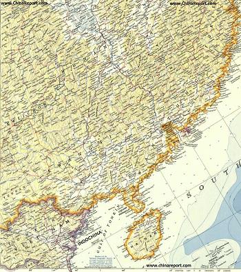
China Report - Historic Map - North Vietnam & South China in 1953 AD
A large Geographic Map of parts of South China and North Vietnam in the year 1953 AD when the Peoples' Republic of China was only 4 years old, the Korean war had recently ended in a stale-mate (which continues to this day) and at the same time the partition of Vietnam into Ho Chi Minh's Socialist Republic of North Vietnam and the American supported South Vietnam was just about to be formalized (1954 Geneva Convention) and taking shape.
Map includes parts of Guizhou Province , Yunnan Province, Sichuan Province, Hunan Province, Fujian Province, Guangxi Zhuang Autonomous Region,Guangdong Province and finally Hainan (Dao) Province of China (P.R.C.). In addition most of the northern "bulge", a total of 26 of the 50 Provinces of the Socialist Republic of Vietnam are depicted. The Provinces shown are Dien Bien, Lai Chou, Lao Cai, Ha Giang, Cao Bang, Son La, Yen Bai, Tuyen Quang, Bac Can, Thai Nguyen, Lang Son, Phu To, Boc Giong, Vinh Puc, the National Capital of Hanoi, Bac Ninh, Huai Duong, Hung Yen, Han Nam, Quang Ninh, Binh Hoa, Ha Tay, Ninh Binh, and the small coastal provinces of Nam Dinh, Thai Binh and Haiphong (City).
The Map makes use of old westernized spelling (Wayde Giles) and where possible current names of cities and towns.
Link through where available to find more information and additional details on each location and region as marked on the Map.
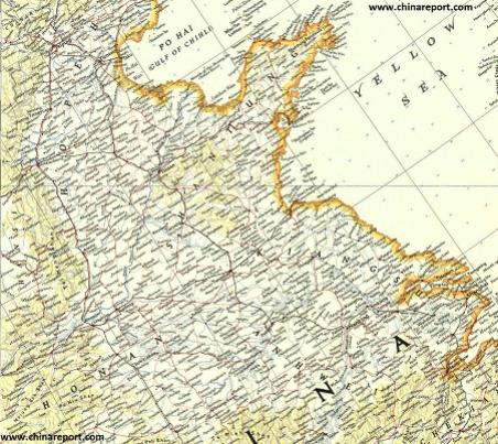
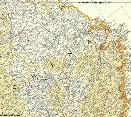
China Report - Historic Map - Shandong, Jiangsu, Anhui Provinces in 1953 AD
An Geographic Map of parts of Shandong Province, Jiangsu Province and Anhui Province of China in the year 1953 AD.
China Report - Historical Maps - Historic Maps of the Peoples Republic
China Report - Historical Maps - Historic Maps China 1910 AD - 1949 AD
China Report - Historical Maps of China
China Report - Map of the Great Wall during the Ming Dynasty
- Online Sources
Maps Of China Online- historic & geographical
This page was last updated on: 26/5/2017
China Report - Rise of European Colonialism in Asia 17Th Century
A Map drawing of the Far East -China, Japan, Korea, Phillippines, Indo-China, Burma, India and Indonesia- in between 1600 AD and 1700 AD. Depicting the Rise of European Colonialism in Asia in the 17Th Century before the start of the Industrial Revolution. Clearly shown - Extensive Dutch trading posts and colonial Territory in South- and South-East Asia (Borneo, Sumatra, Java, Moluccas) with The Netherlands enjoying its "Golden Age" , - British Trading Posts in India and Ceylon, - French- and Portugese Trading Posts and Colonial Territories in India and the East-Indies Islands. Japan "discovered" by De Vries, Captain of the VOC "(United) East-Indies Trading Company" (Dutch) in 1643 AD. Not much later Japan would close itself to western influences and only accept trade with the Dutch, who were allowed one small Trading Post in Nagasaki Harbor (Deshima).
China Report - Historic Map China + British Empire 1860 AD
A Map drawing of the Far East -China, Japan, Korea, Phillippines, Indo-China, Burma, India and Indonesia- in 1860 AD. Depicting the expanding British Empire in Asia and the Far East in 1860 AD, with a Focus on China and Indo-China. British Power has surpassed that of the Dutch (and Portugese) in Asia. British Territory includes India, Burma, Nepal, Bhutan, Sikkim and other strong-points scattered around. Hong Kong is now British (1842AD). Tibet and the bulk of China have come under pressure from Britain.
ChinaReport.comat
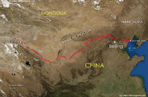
A Satellite image of China and East-Asia, with a super-imposed schematic Map
of the location and Path of the Great Wall as constructed during the Reign of
the Ming Dynasty. Main Features are Names and locations location of Passes on the Great Wall of China, outer layer and inner layer. Includes Shanhai Pass, Huangya Guan (Yellow Cliff) Pass, JiYunGuan Pass, Ningwu Guan Pass, Pingxin Guan, YaMen Guan Pass, Pian Guan Pass, JiaYuGuan pass, YuMen Guan Pass (Jade Gate) and Yang Guan Pass.
Further included for reference are City names, geographical features of landscape and main mountain ranges. Updates occur several times a year adding new pass locations and photo-virtual tours of Passes throughout China.
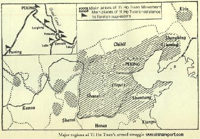
China Report - Historic Map - 1900 AD Yi Ho Tuan (Boxer) Movement
Schematic overview Map of the extend of unrestive area's of North-East China during the 1900 AD anti-foreign and anti-Ching Dynasty Yi Ho Tuan ("Boxer") Revolt and Movement in Shandong, Hebei and Shanxi Provinces and Parts of Shaanxi Province, Chili (Inner Mongolia), Kirin in Manchuria (Jilin Province) and Wuwei in Gansu Province.
Map includes location of Main Cities with links to more information, and names of Treaty Ports. Set in Window provides details of the Tianjin-Beijing railroad and telegraph connections and fortified military stations along it, as well as the rough location of the Grand Canal of the Ming Dynasty in these regions.
China Report - Historic Map - China (Qing) Empire in 1910 AD
An obviously non-Chinese but western-made Map of the Qing Dynasty Chinese Empire in the year 1910 AD, a year in which China's sovereignty has been under threat and siege for over 70 years.
In this Map of 1910 AD, made one year before the abdication of Last Ching Emperor Xuan Tung (a.k.a.Aisin-Gioro Pu Yi) and the final end of China's Feudal History, China is depicted as in its smallest boundaries and definition. Most notably Manchuria, and Inner Mongolia, both territories nominally under Chinese Control and under Chinese Sovereignty are depicted as separate area's.
Other interesting features of the Map and geography of the Time : after the Sino-Japanese war of 1899 AD, both Korea and the Island of Formosa (now Taiwan / ROC) have been annexed by the Japanese Empire.
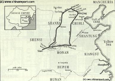
China Report - Historic Map - 1900 - 1902 Route of the Imperial Ching Court fleeing from 8 Allied Nation Forces
A Map coming Soon !
Schematic overview of the flight route of the Court of Empress-Dowager Cixi and the captive Guanxu Emperor during the 1900 - 1902 AD "Boxer War" and aftermath.
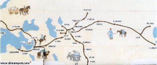
China Report - Map of the Ancient Silk Road during the Han Dynasty & Roman Age 2
A Schematic Map depicting the Full Length and main pathways of the Ancient Silk Road during the Han Dynasty Period (206 BC - 221 AD) and Roman Age (30 BC - 630 AD).
In 30 BC the Roman Empire started trading with India, which was already well known from the Conquest of Alexander the Great (+/- 330 BC). In the following 6
centuries the West would Trade with India and indirectly also with China through the Silk Road. The Silk Road only lost its Value after the European Age of Discovery and the Establishment of Maritime Trade Routes with India (16Th Century) and later China. The Yellow River is crossed at Lanzhou, after which Dunhuang is the Last Station in China.
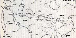
China Report - Map of the Ancient Silk Road during the Han Dynasty & Roman Age 1
A Schematic Map depicting other details along the Full Length and main pathways of the Ancient Silk Road during the early Han Dynasty Period (206 BC - 221 AD).
As seen from China the Silk Road extends due Westward from Chang'An (Xian) the Han & Tang Dynasty Capital. The Yellow River is crossed at Lanzhou, after which Dunhuang is the Last Station. This Map depicts the Lost Civilizations of Loulan and Hotan, as well as the south route and north
route of the Silk Road coming together at Dunhuang in current day Gansu Province of China.
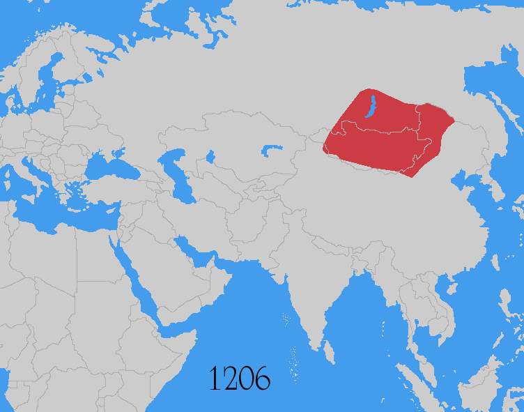
China Report - Map Yuan Dynasty Mongol Empire in Time 1206 AD - 1294 AD
A Schematic Map of the Mongol Empire of Genghis Khan (TeMuJin) and descendants through its several stages of conquest in its short but Impressive Existance in History. Timeline depicts the Mongol Conquest starting in the Year 1206 AD, when Genghis Khan first united the Mongol-Turkic Tribes of Mongolia and Lake BayKal becoming Great Khan. The Timeline continuous through the year 1219 AD, the year 1223 AD taking Transoxiania, 1227 AD, 1237 AD when the Northern Jin Dynasty of China was annihilated, 1259 AD conquering ancient China above the Jiangste River and 1279 AD when all of China was taken and the Yuan Dynasty Eastablished under the Kublai Khan. Last is the Year 1294 AD when the Mongol Empire reached its largest geographical size and Zenith, 22% of world land area, but through lack of central leadership and over-expansion fragmented into 4 large parts, then imploded upon itself.
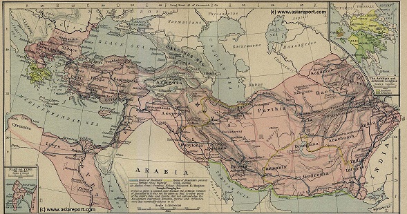
Asia Report - Map Trade Routes in Asia in the 13Th Century
A Schematic Map of the Eurasian Trade Routes existing in the 13Th Century. Clearly marked in Red Accent on the Map are the cities of the network of land-bound trading routes through Central Asia known as the Silk Road (the path of Marco Polo and others). Marked in Blue Accent are the Main Ports and Harbors of the Maritime Trade Routes that operated between the Arabian Peninsula and the Red Sea, the Indian Ocean and Coastal Cities, the Straights of Malacca, the South-China Sea's and beyond. As shown Maritime Trade to China mainly entered through Southern Harbors, then was distributed internally by use of the Grand Canal, the Yangtze River and the Yellow River.
Map includes the Route travelled by Marco Polo, William of Rubruck and John of Pian de Carpine, the three famed European Travelers of the Time.
Locations of Main Trading Ports and Cities on Trade Routes of the Time are marked.
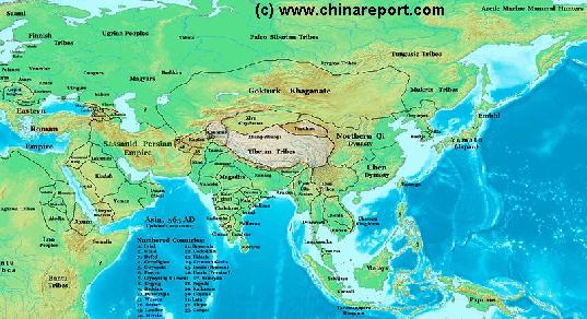
China Report - Map of Ancient Asian Empires and Tribes in Asia 565 AD
An overview Map of Asia Entire clearly demarkating the Territories, Nations and Tribal Area's of the Continent in the year 565 AD. Japan is split between the Yamato Kingdom and Emishi. In Korea three Kingdoms Rule among which the largest Goguryeo. China is split in a Northern Dynasty of the Qi, and a Southern Dynasty of the Chen.
While in the Far west the Qi Empire stretches as far West as Dunhuang, the Silk Road is temporarily blocked by the unification of Mongol Tribes in the Gokturk Khanate and the appearance of the smal XiYe City State in the Tarim River Basin.
China Report - Map of China in the Age o/t Han Dynasty 2nd Century BC + Trade Routes
A Schematic Map depicting the Full extends of the Han Dynasty Empire and its trade relations with neighboring States and Neighboring Peoples and Tribes.
Marked on the Map are the locations of Main Cities of the Han Empire, Han Military Garrisons and Strongpoints, locations of Tributary States (mainly in the West) and the Pathways of Sections of the Great Wall of China constructed during the Han Dynasty Reign Era.
Special Links provide access to additional information on each individual site.
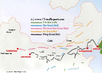
Map of the Great Wall China - Layers of Dynasties and Era's
A Schematic Map of China and East-Asia, with a super-imposed schematic of the various layers of the Great Wall of China.
Features Pre-Qin Dynasty Wall, Qin Dynasty Wall, Western Han Great Wall of China, the (Northern) Jin Dynasty Great Wall and finally the Ming Dynasty Great Wall as mainly remains today.
Main Features are Names and locations location of Passes on the Great Wall of China, outer layer and inner layer. Includes Shanhai Pass, Huangya Guan (Yellow Cliff) Pass, JiYunGuan Pass, Ningwu Guan Pass, Pingxin Guan, YaMen Guan Pass, Pian Guan Pass, JiaYuGuan pass, YuMen Guan Pass (Jade Gate) and Yang Guan Pass.
Further included for reference are City names, geographical features of landscape and main mountain ranges. Updates occur several times a year adding new pass locations and photo-virtual tours of Passes throughout China.
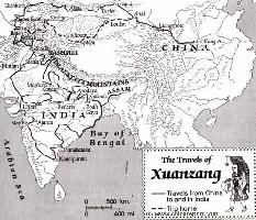
This Schematic Map shows the entire "Journey to the West" as made by the Chinese Monk Xuanzang in the years 629 AD to 645 AD.
The Path of the Journey to India led though China, Kyrgyzstan, Tajikistan, Afghanistan, Pakistan and India. The Return Journey led through Pakistan and Afghanistan to reach Kashgar in current day Xinjiang-Uyghur Autonomous Region of China. Because the (Han) Chinese Cultural Zone during the Tang Dynasty Era only reached as far as Dunhuang, where the Great Wall began, Xuanzang had to travel south-east from Kashgar via Yarkant and Hotien (Khotan) along the South Route around the Taklamakan Desert to finally return to his native China in 645 AD.
Map - Travel Route of Xuanzang - Journey to the West
Asia Report - Historic Map Asia + British Empire 1897 AD
A Map overview of the World in 1897 AD depicting the extenses of the British Empire in North America, Africa, the Mediteranean Sea and the Middle East, Asia and the Far East. British Power is at its highpoint. British Territory includes India, Burma, Nepal, Bhutan, Sikim and other strong-points scattered around. British Controls Hong Kong and has large influence in other Chinese Treaty Ports. Tibet and the bulk of China have come under pressure from Britain. In the next few years parts of Tibet will be annexed.
China Report - Map Yuan Dynasty Mongol Empire in Time 1300 AD - 1405 AD
A Schematic Map of the Mongol Empire of Genghis Khan (TeMuJin) and descendants through its several stages of conquest in its short but Impressive Existance in History. Timeline depicts the Mongol Conquest starting in the Year 1206 AD, when Genghis Khan first united the Mongol-Turkic Tribes of Mongolia and Lake BayKal becoming Great Khan. The Timeline continous through the year 1219 AD, the year 1223 AD taking Transoxiania, 1227 AD, 1237 AD when the Northern Jin Dynasty of China was annihilated, 1259 AD conquering ancient China above the Jiangste River and 1279 AD when all of China was taken and the Yuan Dynasty Eastablished under the Kublai Khan. Last is the Year 1294 AD when the Mongol Empire reached its largest geographical size and Zenith, 22% of world land area, but through lack of central leadership and over-expansion fragmented into 4 large parts, then imploded upon itself.
Asia Report - Map of the Macedonian Empire (336 BC - 323 BC)
A Full Map of the extended Empire of Alexander the Great (of Macedon). Starting his conquest in earnest in 336 BC Alexander the Great defeated the Great Persian Empire, conquered Egypt and advanced through Central Asia as fas as the Hindu Kush and the Heavenly Mountains (Tian Shan) forming respectively todays border of India-Pakistan and more to the North, the border of Xinjiang-Uygur Autonomous Region of China. The Empire included Afghanistan, Tajikistan, Kyrgyzstan, parts of Uzbekistan , etc.
China Report - Colonialism - Growth of Colonies & Japan after 1801 AD
A Map drawing of the Eurasian continent , parts of North-East Africa and the Middle East in the 19Th Century between 1801 AD and 1900 AD. Focal points are the expansion of western colonial posessions of Portugal, Britain and France, as well as Russia moving from West to East. Labeled seperately is the later Rise of the Empire of Japan in the East.
Included in this Map are the main cities across the continent with their brief histories and events during the 19Th Century. Marked in Colors for clarity are the various colonial and imperialist Nations. As relating to China; special attention is payed to so called Treaty Ports. The First Treaty Ports were forced open by Britain in the year 1841 AD, but counted over 80 in total by the end of the 19Th Century. The most important Treaty Ports in China are marked and described with a short history where the map allows. Follow the links for more information on each location and subject.
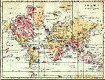
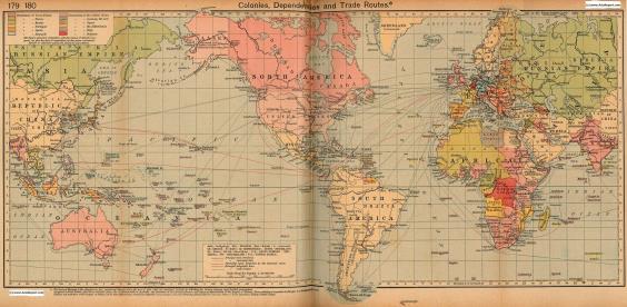
Colonialism - 1912 World Map of Colonial Possessions & Trade Routes.
A Map drawing of the World depicting the Colonial Possessions as they were distributed in 1912 AD. Superimposed and marked in colors are subsequent changes in Influences Spheres, colonies and possessions due to World War I ( 1914 AD - 1918 AD).
Included in this Map are the main cities across the continents with their brief histories and events during the late 19Th Century and early 20Th century, where relevant. Marked in Colors for clarity are the various colonial and imperialist Nations. As relating to China; special attention is payed to so called Treaty Ports. The First Treaty Ports were forced open by Britain in the year 1841 AD, but counted over 80 in total by the end of the 19Th Century.
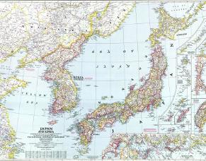
Asia Report - Colonialism - China Coastal Prov., Korea & Japan in 1945 AD
An accurate Geographic Map of the East Asian Coastal Regions of China (Republic), the Korean Peninsula, the Japanese Islands and associated Regions in the Year 1945 AD. At that Time large parts of Manchuria and Inner Mongolia remained under Japanese Occupation as part of the created State of Manchukou, while Korea was actually annexed and to be fully included as a Province of Japan.
Included in this Map are the main cities across the Chinese Coastal Regions, the Korean Peninsula and Islands with their names of 1945 and present day. Marked in Colors for clarity are the various colonial and imperialist Nations.
Included in the Map are Main Cities, Towns and Villages, sections of the Great Wall of China as well as main road connections, railroads, current day sites of tourist interest as well as some of the North Korean ethnic minority villages on the Sino-Korean Border.
All Maps of the Great Wall of China by Province & Prefecture
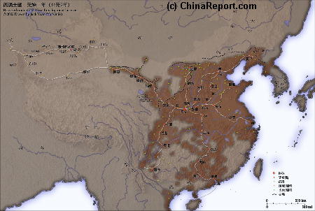
China Report - Historic Map - Central China & Coastal Provinces in 1953 AD
An Geographic Map of parts of Hebei Province, Shanxi Province, Hubei Province, Hunan Province, Jiangxi Province, Jiangsu Province, Zhejiang Province and Fujian Province of China in the year 1953 AD.
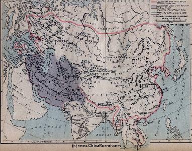
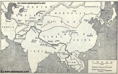
MapHistory - Schematic Asia - Russia China Britain Great Game 1900 AD
A Schematic Map of Historical East Asia at around the year 1900 AD and the turn into the 20Th Century.
Although the Manchu ruled Qing Dynasty Empire had previously conquered large parts of East Asia, including much of Korea, parts of current day Siberia, most of Mongolia, East Turkestan, Kyrgyz, Kazakh's and other tribal lands while subjecting Tibet to a subjugate role nominally ruled for its taxes but yet remote and inaccessible behind its mountainous walls, at the turn of the 20th Century the outer regions of the Qing Empire have been eroded away, much of the north and west increasingly under Russian control while in the south and along the coast Britons and others had fought their way into the Chinese Realm. Notably, Korea has been annexed by Japan and Tibet is shown as a de facto independent territory. Tibet will be invaded by Britain in 1901 AD and will declare Independence not long there after at the fall of the Manchu Dynasty and the end of Manchu rule over
China but also Mongolia and Manchuria in 1911 AD. Other groups such as Mongolians, Kazakhe and Kyrgyz will likewise attempt to reestablish their National independence after the fall of the Manchu Empire.
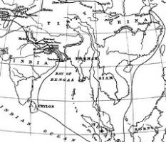
This Schematic Map shows the entire route of the first ever recorded Journey between China and India as made by the Chinese Monk Faxian in the years 399 AD to 412 AD.
The Path of the Journey is less clear than with the later Monk Xuanzang but led though Lanzhou, Dunhuang and Turpan, as well as Khotan and further led through various Central Asian territories today part of Kyrgyzstan, Afghanistan, Pakistan and India. The Return Journey was made by ship and led from the Bengal Coast via Ceylon (Sri Lanka) and parts of current day Indonesia back to the Chinese Coast. Faxian is known to have arrived back in the year 412 AD. His recordings and adventures becoming famous in all of China where they remain legendary to this day.
Map - Travel Route of Faxian (399 AD - 412 D)
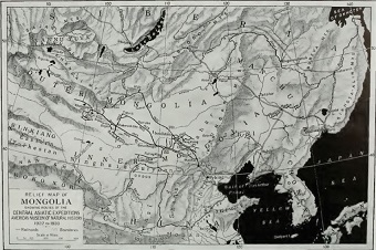
Mongolia Report - Historic Map Roy Chapman Andrews Expeditions 1922/30
A hand drawn Map from the hand of Roy Chapman Andrews depicting the various routes and locations relevant to his expeditions in East Asia between the years 1922 and 1930.
Map depicts north east Asia focussing on Inner- and Outer Mongolia. Map further the Tuva Republic, Irkutsk Oblast, the Trans-Baikal Region, Manchuria and the Russian Primorsky Krai Maritime Province. Other notable features are the Korean Peninsula, parts of north China, the Kokonor Region of the (then) independent Nation of Tibet, and the East Turkestan Republic or Territories (Xinjiang), at the time in disarray and under heavy Russian (Soviet and other) influence.
Click the Buttons and follow the Links to more information on each location and subject.
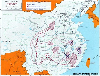
China Historic Map - Route Long March 1934/35 - 1A
A Schematic overview Map of the current Peoples Republic of China depicting the main route(s) of the epic Long March of 1934 and 1935.
Map clearly delineates PRC China current National borders and includes Provinces and Autonomous Regions, Main Cities and relevant Towns, initial Communist Soviets (Self-administered rebel areas), the routes followed by various elements among the Communist Groups and Armies, locations of important meetings points, main natural obstacles such as mountain ranges, the flow of large rivers such as the Yangtze River and Yellow River, position of the Great Wall of China in Gansu Province, Ningxia Hui Autonomous Region, North Shaanxi Province etc, rough estimated routes of main railroads of the time and other details of interest.
Mouse over locations and link through for additional information on each location.