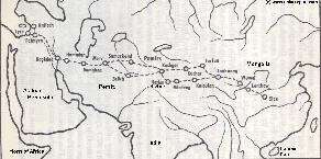
Another Schematic Map of the path and full length of the Silk Road depicting the Silk Road as it was during the later Roman Empire and beyond. Until perhaps as late as the 9Th or even 12Th Century the path depicted was the main route of the Silk Road.
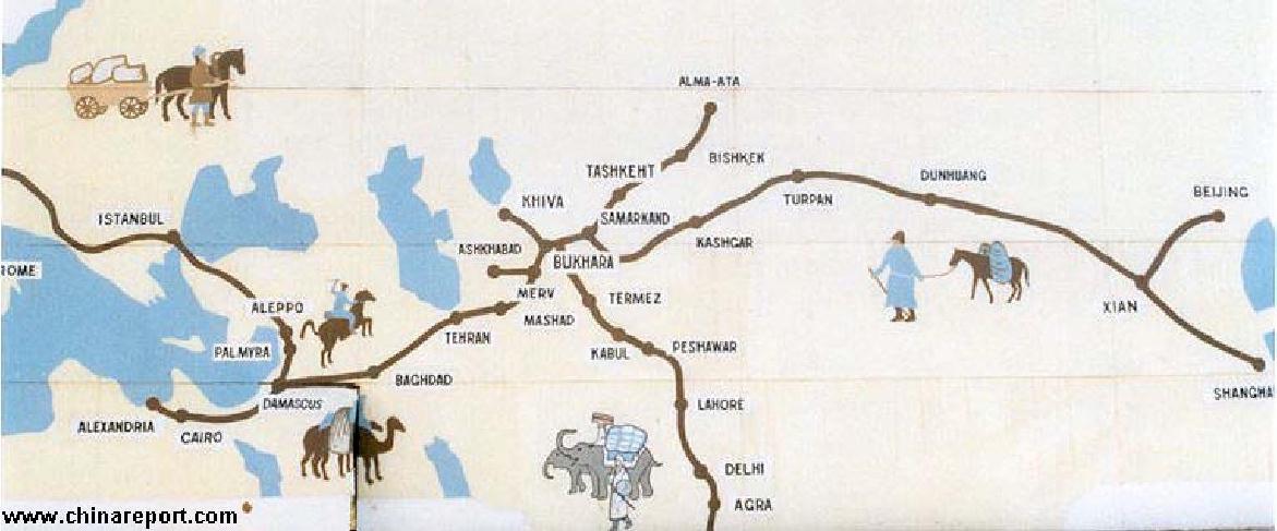
This Map is only a rough sketch, but includes all main trading cities and strategic strongholds along the Length of the Eurasian overland Trade-Route known as the "Silk Road".
The China Report
Map China - History - Silk Road & Cities 2 : Roman Age-Han & Tang Dynasty
Sogdiana
Kathmandu
Lhasa
Wuwei
Bactria
Taklamakan
Badi
YueZhi
DaWan
Xiong-Nu
West Yue
South Yue
East Yue
Parthia
Persia
North
South
East
West
Designates Chinese Controlled Territory
ChinaReport.comat
Map 1 of the Silk Road during the early Tang Dynasty Era. Clearly depicts the North & South Routes West of Dunhuang as well as the lost civilizations of Loulan and Hotan.
- 221 AD) sent emissaries to the North-West where Oasis Cities and Independant Kingdoms held valuable Treasures and Commodities. After much effort these missions and several military campaigns
in competition with the Xiong-Nu Tribes of the North resulted in the establishment of the first trading route west to Parthia in the 2nd Century BC. Bactria with its Capital Bactra (Balkh in Afghanistan) was a rich source of magnificent tall and strong horses giving the Chinese new Military Powers.
Gaining new strength and even greater mobility in battle with the strong horses, in 121-119 BC the Han Dynasty launch a Military Campaign to reach as far west as Buchara (current day Uzbekistan), finally
Province. Colonists were sent to Gansu and the Hexi Corridor to establish and strengthen Chinese Dominance over this Region inhabited by the Yueh People.
The Xiong-nu Tribes which inhabited the regions along the Silk Road in Bactria and Parthia (current day Uzbekistan + Turkmenistan) were driven north of the Gobi desert.
The Tarim Basin was brought under Han Chinese Control (117 BC). The Oasis of Turfan in present day XinJiang AR was conquered by Famed Han Emperor Wu Di (140 BC - 86 BC ) after which soon the Tian Shan High Mountain Range (89 AD) and the City of Kashgar was reached. The subjugation of the City of Kashgar finally opened the road to ancient Parthia, Persia and the West beyond. By 97 AD a 70.000 strong Han Chinese Army under Leadership of legendary General Ban Chao pursued the Xiong-Nu as far as the Western Shores of the Caspian Sea and the City of Ashkhabad on the Silk Road, laying the final keystone for the founding of the Chinese Silk Road Trade Path.
After suffering the final Loss of Kashgar in 60 BC the Xiong-Nu lost all control over Silk Road trading Cities forcing them to look to the West. In 34 BC the Western Xiong-Nu Empire was ended by the Han Dynasty capture of their main stronghold and killing of their Leader in the valley of the Talas River in Soghdiana. Their migration to other regions in the West will later (3Rd & 4Th Centuries) result in the Xiong-Nu Raids in Europe where they will become known as the "Huns".
Although the Xiong-Nu would return for a short period after 18 BC (when the eastern Xiong-Nu regained independance) and troubles would remain with the Xiong-Nu until 216 AD, regaining control of Kasghar and even shortly threatening Chang'An, the Han would go on to Rule the West and the Silk Road. In the aftermath of the Chinese Victory the Han Dynasty Empire and Chinese Generations after prospered on trade on the Silk Road until as late as the 14Th and 15Th Centuries . In 166 AD, the first trading emmissaries from the Roman Empire arrive in Tongkin (current day Yunnan Province), since 43 AD under Han Dynasty control.
defeating the Mongols in the Battle for Control of the Trade Route Oasis Cities and establishing a flourishing Trade Route to reach even Athens and Rome in the West.
Part of Roman Empire Territory
During the raging Campaign (121 BC-119 BC) for control of the earliest Silk Road The Great Wall was extended to the Jade Gate, Yu Men, North-West of Dunhuang in current day Gansu
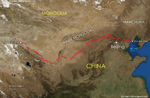
Satellite image of China and North-East Asia, with a super-imposed schematic Map of the location and Path of the Great Wall as constructed during the Reign of the Ming Dynasty. Included for reference are City names, geographical features of landscape, Names and locations of Passes on the Great Wall of China.
Xiong-Nu
Xiong-Nu
DarDa
X <- Jia Yu Pass
Gobi Desert
Gobi Desert
Kyrgyzstan.
Afghanistan.
Tibet.
Turkmenistan.
Uzbekistan.
Pakistan.
Kazakhstan.
Iran.
Iraq.
Syria.
India.
Jordan.
Tajikistan.
China.
Hotan - City Kingdom on the southern edge of the Tarim River Basin and the Taklamakan Desert, due south-east of Yarkent in Xinjiang AR. Existed as a City Kingdom from 300 BC to 100 AD during which period the City and Region had their own language now known as Khotanese.
The City of Hotan or Khotan Kingdom was famous for its Jades, transported from nearby Mines in the Kunlun Shan and from Tibet in the South.
Hotan would become the main source of (Nephrite) Jade in Han Dynasty China. The Jade was traded against Silk, Seeds and other commodities.
Khotan or Hotan was the first Buddhist State in World History.
Between 1006 AD and 1165 AD, Hotan was part of a Muslim Khanate. Much later during the Qing Dynasty, the "Dungang" islamic revolts of 1865 to 1874 once more temporarily turned Hotan into independent Muslim hands (a time during which the Mogao Caves at Dunhuang were vandalized!). A few years thereafter Hotan briefly became part of the short-lived state known as East Turkestan, after which the Han reasserted their Chinese authority over the entire Region, lasting to this very day.
Kashgar - Disputed Trading Oasis and Cross-Roads City at the Western Foot of the Tian Shan Mountain Range. Since +/- 80 AD, with intermittance, under Chinese Control and today part of Xinjiang Autonomous Region of China. Kashgar is part of the Northern-most section of the Silk Road. From Kashgar Trade Routes lead North through Tajikistan to Almaty. To the South-West another trade route connects to Balkh in current day Afghanistan, once part of the Ancient Parthian Empire. A 3rd Route leads from Kashgar to the North-West through Kyrgyzstan to Fergana, a city just inside current day Uzbekistan. From Fergana the North-Route lead on to Tashkent, today Capital of Uzbekistan.
Loulan - (Former) Lost City on the Southern Edge of the Tarim River Basin and the North-West Shore of (former) Lop Nur (Now a Salt Lake). Loulan was established in 200 BC and its inhabitation lasted until around 1000 AD, as an important Oasis of the Silk Road. In the eary Han Dynasty Loulan, aso known as Lop, was a prosperous Oasis City and independent Kingdom rich in fish, fruits and agricultural produce. Zhang Qian, the 1st Han Dynasty Emissary to the West, described Loulan as a fortified city near Lop Nur. In 77 AD Loulan's King was assasinated by a Chinese Envoy and the City Kingdom turned a Chinese Vasal State. Between 100 BC and 200 AD, Loulan was one of the locations over which influence was most heavily contested by the Xiong-Nu Empire.
In 1899 AD Loulan was rediscovered by Svedish Explorer Sven Hedin, after being lost to history for a 1000 years. Further discoveries at Loulan were made by Hungarian Marc Aurel Stein.
Dunhuang - In History known as the "Mouth of China", west of which lay the deadly Taklamakan Desert and wild and restless tribal area's. West of Dunhuang in Gansu Province, the Silk Road split in a southern route from Yang Guan Pass, along the southern edge of the Tarim River Basin to LouLan (Lop), Hotan, Yarkant and Kashgar. The North Route from Dunhuang via Jade Gate (YuMen) to Kashgar followed the Tarim River along the Northern Edge of the River Basin from Lop Nor through Kumul (Kunmo or Hami) and Turpan Oasis after which both routes rejoin at Kashgar.
Buchara - Established around 500 BC, Buchara had already been an Oasis encampment for 2500 years before. It has long been a city of Trade, Learning, Culture and a seat of Religious Leaders. Buchara of history was a city with a strong Persian background and Culture. As Capital of Soghdiana, a Persian Vasal State, it was a major trading city on the Silk Road connecting in all directions. East to China, South to India, South-West to Parthia and the far West and North through Samarkand to Alma Ata (Almaty) in the Steppes. Around 300 BC, the City of Buchara was conquered by the armies of Alexander the Great, becoming part of the Greek-Empire as the Hellenic Kingdom of Greco-Bactria. The Greeks were driven out by the Khusans, a Nomadic migrant tribe in around 135 BC, after which the Han Chinese were to enter the scene. Under the Khusans, who were Zoroastrian in Faith and later turned Buddhist, Buchara swayed under strong Persian and Indian influences. The Khusan Empire added to the Trade on the Silk Road by connecting it to the Sea Trade ongoing on the Indian Coast. Remaining in power in the region untill the 2nd century AD, the Khusans under Kanishka made various forays Northward into the Tarim Basin during weakness and fall of the Han Dynasty, effectively hindering Chinese Trade on the Silk Road. The Khusan Empire is known in China by their original name, as they are descendants of the Yue-Zhi (Yue-Chi).
Buchara Khanate became part of the Russian Empire in 1872/73 AD.
Cities, Oasis and Kingdoms on the Silk Road :
Caspian
Sea
Aral
Sea
Black Sea
Mediterranean Sea
Kunlun Mt. Range
Turpan - Turpan in Xinjiang-Uygur was under Chinese Control by 90 AD, at the very latest. Although incursions by vengeful Nomadic Tribes would threaten and conquer Kashgar and Turpan several Times, Turpan would return to Chinese Rule or Dominance. Today Turpan is a prefecture level city in Xinjiang Autonomous Region of China (P.R.C.), due South-East of Urumqi.