6 BC-AD 5: Han Dynasty loses control of Tarim
River Basin to Huns. The Silk Road is blocked.
Schematic Map of the many sub-pathways of the Silk Road in China clearly showing the one-unavoidable pathway of the Hexi Corridor.
Dunhuang, Gansu Province, China
ZhangYe, Gansu Province, China
JiaYuGuan, Gansu Province, China
Lanzhou, Capital of Gansu Province, China
Xi'An, Cpaital of Shaanxi Province, China
Qilian Mt Range
Mazhong
Mt Range
Taklamakan Desert
Qinghai Plateux
Gobi Desert
Gobi Desert
Tibetan Plateux
Tian Shan
Mt Range
Kashgar, Xinjiang-Uygur AR, China
Urumqi, Capital of Xinjiang-Uygur AR, China
- China Report !!
China and the Silk Road - Earliest Development of Civilization and Overland Trade with the West

The origins of China and the Chinese go as far back as 5000 years before Christ, or more. Evidence of inhabitation in the era of 10.000 BC, at the end of the new Stone Age (neolithicum), can be found at Helan Pass (Sangguankou) in Ningxia Autonomous Region, and along the Northern Mountain Borders of Xinjiang-Uygur Autonomous Region, in current day Gansu Province as well as in the Inner Mongolia Autonomous Region.
In these early ages the Western Regions of what today is China were already populated, as well documented archeoligical finds have proven. These were however very primitive and dark tribal times, with men living in close contact with nature as hunter-gatherers. There population was very sparse, there was no agriculture and thus there were no cities. Small groups of People moved about on Foot.

In the succeeding period the earliest Chinese civilizations were primitive societies which had just developed agricultural skills and had invented such primitive tools & pottery. The first complete societies only arose at around 5000 BC. In China these societies/tribes were located in the lower reaches of the Yellow River, counted many more citizens and spawned the first true villages and cities.
Similar to early civilizations elsewhere in the world, they knew of no script at first.
Through the emergence of what could be recognized as the true earliest interactions along Trade Routes that would later emerge as the famous Silk Road, from this point the early Chinese would move remarkably quickly on the ladder of inventions and civilization. As the Science of Archeology figures at up to now, the first true intercultural contacts in the far western regions (Xinjiang, Taklamakan Desert, Hexi Corridor of Gansu Province) were established after the invention of the wheel combined with the domestication of horses. Although human migration and contacts reach far further back to the dawn of the species, itself. Beforehand small bands of humans had walked the distance, only to settle and henceforth keep to themselves. Many 1000's of Years passed until the invention of the horse-drawn carriage (Chariot) made rapid transportation over large distances possible for the first Time in Human History. It was a great tool for war, travel
and transport. According to various intriguing finds done further West in the Tarim River Basin, this new Era,
estimated around 3500 years ago saw the dawn of the first small scale trade routes (nothing of the scale of trade
the later Silk Road saw) in Central Asia stretching into Taklamakan Desert which in time led to large scale cultural
and economic exchanges.
A Chronology of the Silk Road
Estimated 500 BC - 14Th Century Emergence Maritime Trading Routes
This page was last updated on: December 4, 2011
To Doc Ben's Webring
This page was last updated on: December 4, 2011
Vintage Art posters and prints
Spectecular IMAX Movie on Chin Shi Huangdi , founder of the Great Wall of China
The spectular IMAX special about the Life, Times and Legacy of China's 1st Emperor Ch'In.
Buy it at Movie Universe - Click Here
Click to go to Tour of Yungang Caves !
Smaller examples buddhist cave art of the Monumental Wei Dynasty buddhist statues of Yungang near Datong in Shanxi, still colorful after 1800 years. Other Wei Dynasty caves, evidence of the penetration of buddhism on the silk road, are found at LuoYang in Henan, Lanzhou in Gansu and other places.
Unique Source
5 DVD Set
"Yellow River"
( available from our Online Store )
The Best Documentary Ever on the Yellow River !! All 5000 kilomters followed and shown !
Click Map to View !!
Overview of the Length and Path of the Great Wall of China of the Ming Dynasty. Includes links to Cities and Great Wall of China Passes. - Click Map for Full Version !
himself to the domestication of all farm animals of the early civilization. Among them small horses, the cow, goat and others.
Summarized the legends explain mythically and romantically how the first inventions and developments had been made, and how the first agricultural civilization with script came into being in the yellow river basin of China. From there it would spread into an ever larger territory and would be touched by many cultures and peoples and idea's.
Although wrapped in Legends of history, the mentioned archeological finds do underwrite the development of early sedentary civilization in China at around 6- to 5000 years BC. The most well-known find is found on the outskirts of present day Xi'an in Shaanxi Province, a city that would later remain at the center of early civilization and was home to the Capital of Han and Tang Dynasties. Here the Ban Po neolithic village gives a good insight into what the dawn of Civilization in the far east on the eur-asian continent was like. Other sites include those near Yangshao Village in Henan Province, the Shandong Province Longshan Culture finds and even some finds at Wanfujing in Beijing, Hebei Province.

The China of the earliest dynasties was nothing like that early China of 5 or 6 thousand years ago, just as today's China does not much resemble the China of the Feudal Ming Dynasty or even Ching Dynasty. However, recorded history and script start with the Shang Dynasty. In the process of further building their civilization, the structure of the state, the size of the state and
its territory, the people, ethnic groups, food, habits and culture all changed numerous of times, to end up as today's customs, China, Chinese people and culture. In this process the Silk Road pathways and the Culture and Technology they carried played a pivotal role.
The centralized state, only distantly similar to today's political situation, developed somewhere in the 3rd century BC and was first truly established and developed by the Chin Shi Huangdi and his short-lived Chin Dynasty. Slowly a feudal system as we know it evolved, through several stages. As Time advanced, each Dynasty would have its own power-structure and organization, depending on needs, philosophic and technical developments. The better organized, the more powerful militarily.
The Chinese Culture and Territory had expanded and united under the Ch'in and although it disintegrated several times, the Chinese Culture Area would keep expanding in all directions.
A Magnificent Liao Dynasty Era (907 AD -1125 AD) carved Statue of GuanYin, the Goddes of Mercy (Clay on Stone). At the Shanxi Provincial Museum of History, TaiYuan, Shanxi Province.
China Report - Historic Map - China (Qing) Empire in 1910 AD
An obviously non-Chinese but western-made Map of the Ching Dynasty Chinese Empire in the year 1910 AD, a year in which China's sovereignty has been under threat and siege for over 70 years.
In this Map of 1910 AD, made one year before the abdication of Last Ching Emperor Xuan Tung (a.k.a.Aisin-Gioro Pu Yi) and the final end of China's Feudal History, China is depicted as in its smallest boundaries and definition. Most notably Manchuria, and Inner Mongolia, both territories nominally under Chinese Control and under Chinese Sovereignty are depicted as separate area's.
Other interesting features of the Map and geography of the Time : after the Sino-Japanese war of 1899 AD, both Korea and the Island of Formosa (now Taiwan / ROC) have been annexed by the Japanese Empire.
Map of China - Ching Dynasty Empire in 1910 AD
Getaway Specials from Marriott.
Music Bonus - Ancient Chinese Classical Melody "The Moon is High in the Heaven".
Click to go to Silk Road Map 2 !
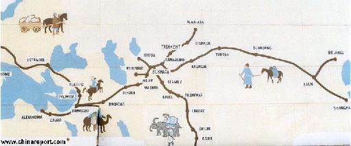
A 2nd Schematic Map of the Silk Road during the Roman Age. In 30 BC the Roman Empire started trading with India, which was already well known from the Conquest of Alexander the Great (+/- 330 BC). In the following 6 centuries the West would Trade with India and indirectly also with China through the Silk Road. The Silk Road only lost its Value after the European Age of Discovery and the Establishment of Maritime Trade Routes with India (16Th Century) and later China.
China Maps
China Online Sources
China Offline Sources
China Online Store
China Photo Galleries
Historic Maps
Art & Culture
History
China News
China Politics
DrBen.Net Home
China Provinces /Home
DrBen.Net Partners
China
Asia Countries /Home
Asia
China Report Club
Blog
Chat
Forum
Provinces Maps
China Travel
Great Acting & Costumes in this One of a Kind Production DVD - Buy it Here !
Marco Polo - The True Story, a remarkable documentary revealing the likely truth about Marco Polo's epic Journey and adventure !
Buy it - Click Here
Click to go See Full Version !
The 15Th Century Map of Piri Reis, found at the TopKapi Palace in Istanbul, included much knowledge transmitted on the Silk Road
& early
Maritime
Routes.
Find out all the Basics and More on Mattheo Ricci, First Christian Missionary in China !
Source Book
"Following the Steps of Mattheo Ricci to China"
( available from our Online Store )
Buy at Art.com
Foreign Tributaries En Route to China
Buy From DrBen.Net
Return to The China Report Home
Source Book
"Story of the Silk Road"
( available from our Online Store )
Click to go to Map 1
Map 1 of the Silk Road during the early Tang Dynasty Era. Clearly depicts the North & South Routes West of Dunhuang as well as the lost civilizations of Loulan and Hotan.
From the Warring States Period to the Ch'In and Han Dynasties :

10Th Century BC: King Mu (Reign 976 BC to c.922 BC) of the early Zhou Dynasty (1122 BC to 256 BC) is the Chinese person known to have traveled on Silk Road. King Mu of Zhou is counted among the most succesful of Zhou Rulers and during his Reign period the surface area of the Zhou State reached its largest size, expanding the territories from the Lower reaches of the Yellow River far into the West and South. Accoring to record, during his reign period the King traveled some 90.000 kilometers, reaching the Kunlun Mountains (Kunlun Shan) in far Western China.
China Report - Map Yuan Dynasty Mongol Empire in Time 1206 AD - 1294 AD
A Schematic Map of the Mongol Empire of Genghis Khan (TeMuJin) and descendants through its several stages of conquest in its short but Impressive Existance in History. Timeline depicts the Mongol Conquest starting in the Year 1206 AD, when Genghis Khan first united the Mongol-Turkic Tribes of Mongolia and Lake BayKal becoming Great Khan. The Timeline continues through the year 1219 AD, the year 1223 AD taking Transoxiania, 1227 AD, 1237 AD when the Northern Jin Dynasty of China was annihilated, 1259 AD conquering ancient China above the Jiangste River and 1279 AD when all of China was taken and the Yuan Dynasty Established under the Kublai Khan. Last is the Year 1294 AD when the
Click to go to Map !
Mongol Empire reached its largest geographical size and Zenith, 22% of world land area, but through lack of central leadership and over-expansion fragmented into 4 large parts, then imploded upon itself.
AD 906-1279: The Silk Road of the Sung Dynasty and the Mongol Empire.

1206 AD: Mongolian tribes unify and begin to conquer Asia under the rule of Genghis Khan.

1207 AD and 1210 AD : The first Mongolian Invasions against Western Xia (Xi Xia) and Uygur-Turks.

1220 AD: Genghis Khan captures Khotan, part of what is known as the Western Xia Empire or Xi Xia.

1226 AD: The City of Khara-Koto, Capital of the Western Xia (Tangut) Dynasty falls to the Mongol Armies of Genghis Khan.

1245 AD - 1247 AD John of Pian de Carpine, becomes the First of the three famed European Travelers of the Time to travel Eastwards along the trade roads of Central Asia, ending up at the Mongol Capital Karakoram and Ulaanbataar in Mongolia.

1253 AD - 1255 AD William of Rubruck travels from West to East along the Silk Road to Karakoram in Mongolia.
1260 AD - The Mongol Tribes capture North China and although battles rage on in the South the Yüan Dynasty is established (Mongolian). The First Emperor of this Dynasty is the Mongolian Kublai Khan, grandson of Genghis Khan.

The Mongol Rulers give high importance to trade on Silk Road pathways, the communications lines of their Empire.
The 3 Kingdoms and succeeding Sui and T’ang Dynasties:

221 AD -265 AD : Period of the “Three Kingdoms;” China gets divided into rival dynasties.

226 AD : Chinese sources record a Roman trading party reaching China from India via a Sea-Route.  Romans have managed to bypass both the Persian and the Indian sea-trade monopolies.

286 AD : Chinese sources record another Roman Trading Party reaching South China. After this visit Roman sea-power declines making direct contacts between the Roman Empire and China increasingly rare. Persian fleets take control of the Seas.
325 BC: Palmyra and Parthia reconquer Persia.

206 BC: Qin Dynasty collapses; Han Dynasty takes over under the rule of Emperor Liu Pang.
mid 2nd c. BC: Tokhari people migrated from Bulunghir-gol to Khotan.

138 AD : Emperor Han Wu Di sends out his emmissary Zhang Quian’s (Chang Ch'Ien) from Chang'An to the Western Regions. Goal of the Mission is to make contact with and forge alliance with Yue Zhi. Chang Ch'Ien sets out with a 100 Men but is captured soon by Huns. After lenghty imprisonment and other events, the failed Mission returns to Court many years later in 1125 AD with valuable information on the regions crossed. The Yue Zhi posses powerful horses.
115 BC: Han Dynasty Emperor Wu Ti forces the Huns to retreat to the north of the Taklamakan Desert. Afterwards, the Han construct a first version of the Great Wall of China extension to the West, in protection of the Silk Road. The Han Dynasty Great Wall reaches at least as far West as JiaYu Pass (JiaYuGuan City) in the Hexi Corridor of Western Gansu province. Later, the Ming Dynasty Great Wall of China, which also served in protection of the Silk Road trading routes in Central Asia would end at JiaYu Pass, where a Great Fortress of JiaYuGuan was constructed in 1372 AD.

In 115 BC Zhang Quian is sent on a second diplomatic mission to the West, this time destined for Daxia and Parthia (North Persia) on the Far Western Silk Road. As a result Diplomatic Missions from The far West are sent in Honor to the Han Dynasty Court at Chang'An (Xi'An), the beginning of enduring diplomatic relations with these far western Nations, India and Persia.
1271 AD : Pope Gregory meets the Polo Brothers in Jerusalem after their first Journey to Cathay (China).

1272 AD : Marco Polo joins on a papal diplomatic mission to the Court of the Kublai Khan at Khanbalik (Beijing) in Cathay, the Far East. The Route in China leads through Kashgar, south around the Taklamakan Desert via Dunhuang into the Hexi Corridor. On his way Marco Polo visits the Mogao Caves at Dunhuang and the Big Buddha Temple of Zhangye (and alledgedly Jiuquan) which are later recorded in his book. Khanbalik is reached in 1274 AD, when Marco Polo meets the Yuan Emperor Kublai Khan at the Court.
1293/1294 AD : Marco Polo and the Brothers are finally allowed to leave the Service of the Kublai Khan, finally arriving back through the fast emerging Maritime Silk Road to Venice. Later Marco Polo will write his memoirs of the travels, his book "Il Millione" while stuck in a Jail.

1328 0r 1329 AD: The Arch-Bishop of Khanbaliq, John of Montecorvino dies.

1329: As a replacement for the deceased Arch-Bishop of Khanbalik, Pope John the 12Th ordains the Franciscan Monk Nicolas, who then sets of to Travel to the Far West and take up office in Khanbaliq. Not much is heard of him afterwards. Records hold it that Arch-Bishop Nicolas reached the town of Almalik, which is located due South of Lake Balkash in current day Kazakhstan. He never reached China however and probably died in 1329 AD.

1334 AD : Moroccan Traveler Ibn Battuta (complete: Abu Abdullah Muhammad Ibn Abdullah Al Lawati Al Tanji Ibn Battuta) travels in East-Asia, South-East Asia and China. Although Battuta does not travel by the land route of the Silk Road into
1865 - 1874 AD : The "Dungang" Islamic revolts (or Hui Minorities' War, or the Muslim Rebellion) once more temporarily turned Hotan into independent Muslim hands (a time during which the Mogao Caves at Dunhuang were vandalized!). A few years thereafter Hotan briefly became part of the short-lived state known as East Turkestan.

1872/73 AD: Buchara Khanate becomes part of the expanding Russian Empire in East-Asia.

1875 AD: Dungang / Hui Minorities are removed from the Hexi Corridor in Gansu and resettled in the South-West of the Province in order to prevent contact between the Muslim groups and
, Lop Nor, Loulan and Khotan, to Kashgar in Central Asia and, via what today is the pathway of the Karakoram Highway, on to India. The goal behind the mission was simple: to acquire better knowledge of Buddhism than was available at that Time within China. The Monk hoped to bring back the teachings of the Buddha where possible in the form of scrolls and scriptures.
In his later published accounts of his travels Fa Hsien describes Khotan City, Kucha and Turpan (Turfan), Khotan (Yutien), the Taklamakan Desert, Taxkorgan - the ethnic home of the Kazakhs, and in general the daily Life and Culture of the various peoples and regions he traveled through on his way to India.
Although the travel accounts of Fa Hsien are not always sufficient to pinpoint exact locations, nor his exact route of travel, his account does provide interesting information on the conditions of travel and the Buddhist sites and practices he witnessed. Interested as he was in the practice of Buddhism and its exact theology Fa Hsien clearly indicates the importance of the seven precious substances in Buddhist worship, the widespread practice of stupa veneration, and his acquaintance with several of the jataka tales about the previous lives of the Buddha Sakyamuni, tales which are illustrated in the paintings at the Mogao Caves just outside of Dunhuang in Gansu Province.
Although Fa Hsien traveled to India overland, he returned by Sea. After a two year stay in India, he was shipwrecked (probably on the island of Java). Nevertheless he managed to return to Qingzhou in
5th-6th century AD: Silk Road traffic increases along with Buddhist influence, with 2 million Buddhists in China by 514 AD. The Gandharan Kingdom extinguished by Hephtalite (White Hun) invasions.

540 AD : Rise of a Wall of Anushirvan, built on orders of the Persian King Anushirvan the Just (Chosroes I (Kasra) of Persia - انوشیروان عادل , Reign: 531 AD - 579 AD). The wall reaches from western beach of the Caspian Sea to the City of Anushirvan and from there across the ridge of the Caucasus in order to dominate cross-border Trade.  It became known as the Iron Gate (Mongolian: Timur Qapu). Parts remain today.

552 AD : Nestorian Monks succeed in smuggling out Silk Worms from the Chinese Empire. After a perilous journey the Monks present the Silk Worms and spied technology to Justinian, Emperor of the Eastern Roman Empire based in Constantinople (current day Istanbul). Delighted the Emperor orders the creation of Royal Silk Farms and silk weaving factories.
This is the first Time the Chinese Monopoly on Silk Cultivation and production technologies has been broken.
Chinese Silks remain however the highest in quality and Silk Road Trade continues uninterrupted.
The Path of the Silk Road in Asia and China :

The Silk Road was a transcontinental trading path connecting Asia, Entire, North Africa and Europe.
Countries connected through the main pathways of the land-bound Silk Road are China, Kyrgyzstan, Afghanistan, Pakistan, Uzbekistan, Kazachstan, Turkmenistan, Tibet, India, Syria, Iran, Iraq, Egypt (Cairo and Alexandria), Turkey, Italy (Rome).
Apart from the Main Route there are several parallel pathways traversing North around the Caspian Sea and along the Eastern Shores of the Black Sea. Today these territories include the countries of Azerbaidjan, Armenia (ancient part of Persia), Georgia and parts of Ukraine and Russia.
In the South-East ran another minor Silk Road pathway, best identified as the South route of the Silk Road from China to India. This trade route included the Nations of China (Yunnan Province), Myanmar (Bhurma), Tibet (Autonomous Region of China) and Qinghai Province.
Pre'- History of the Silk Road:

3000 BC : According to various archeological finds, among which murals and depictions, as well as ancient silk cloth and threads derived from Tombs and Mummies and ancient burial jade inscriptions, the earliest cultivation and weaving of Silk takes place at around 3000 BC. Possibly already in the Late Stone-Age, around 10 to 8000 BC primitive peoples in Eastern Asia already knew how to derive fibers from the Silk Worm, however this reamins uncertain.
Silk Reeling and Silk Weaving were original Chinese Inventions.

4000 BC : In Chinese Folklore and Saga, around 4000 BC one of the 3 Old Sages, the Yellow Emperor, is said to have introduced Silk Worm cultivation by use of the Mulberry Tree and taught the Chinese People how to make Silk.

1600 BC - 1100 BC : Complete knowledge of "Silk Technology", farming, extraction and weaving are available during the Shang Dynasty Era.
and progressive fall of the Cities and Provinces of the Achaemenid Persian Empire. The Persian Empire King Darius dies but the conquest continues eastward as far Bactria and Sogdiana territories due west of the Pamir Mountains. Around 330 BC Alexander (Dhu'L Qarneyn) alledgedly builds the "Copper Gate" (according to the Quran) in order to protect his subjects from maurauding nomadic tribes Gog and Magog 'from the north'.
Bactria and Sogdiana become part of the Macedonian Empire of Alexander the Great by 326 BC, establishing a first European Presence on the Central Asian paths of the Silk Road.
The Armies of Alexander move over the Hindu Kush into India afterwards. The Empire disintegrates after the Death of Alexander in 323 BC.
712 AD: Kuteybeh Ibn Muslim conquers west Turkestan including Khotan; probable
destruction of Buddhist temples at Khotan.

845 AD : Persecution of Buddhists by Muslims begins. Anti-Buddhist movement of the 9th century: 4,600 temples reported to be destroyed, with 260,500 monks and nuns defrocked. Large Scale Vandalism of Buddhist Statues at LongMen Caves, near LuoYang in Henan Province.

906 AD: Fall of T’ang Dynasty; rise of Five Dynasties (AD 907-960).

9th-10th c.: Silk Road traffic and Khotan both decline as Buddism begins to wane. Arabs take over
Silk Road trade domains and start acting as middlemen, raising prices. As a result the Maritime Routes, the“Sea Silk Route” to China become more economically attractive.

1006 AD to 1165 AD, the Western Taklamakan Desert City and former Chinese Vasal State, the City of Hotan falls into the hands of the advancing Muslim Kara-Khanid Khanate arising in the West.
The Silk Road southern path along the Taklamakan Desert falls out of control of the Han Chinese.
-----> History of the Silk Road :
Silk Road & Cities Online Sources
See Also - The Han Dynasty and the Tang Dynasty history.
[ Back to Top of Page ]
Go to Top of Page !
[ Back to Top of Page ]
Go to Top of Page !
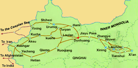
The Silk Road inside of China and the Chinese Empire, which was established during the Wu Di Reign of the Han Dynasty and thus active from the 2nd century BC onwards, led westward from the Han Dynasty and later Sui Dynasty and Tang Dynasty capital at Ch’ang An (near Xi'An), via Lanzhou where the Yellow River was crossed into the Hexi Corridor of current day Gansu Province. In the Hexi Corridor all Pathways had to pass through the JiaYu Pass, since 1372 AD the location of JiaYuGuan Fortress on the Great Wall of China. From JiaYuGuan the route led on to Dunhuang (Tun-huang) at the edge of the Taklamakan Desert. At Dunhuang the Chinese Territory ended and the pathways of the Silk Road diverge to the North and South. The North pathway leads through Jade Gate (Yu Men) past Lop Nor Lake to Turpan and further along the Tarim River Basin and the Northern Edges of the Taklamakan Desert to Kashgar. Equally, the South Route out of Dunhuang leaves out of Sun Gate Pass (Yang Guan) to head south along the Cherchen and Keria Rivers to reach Khotan and then Kashgar along the South Rim of the Desert, while keeping along the North Rim of the Tibet-Qinghai High Mountain Plateaux.
The two pathways out of Dunhuang, last bastion of ancient China, reunite at the City of Kashgar in far western Xinjiang-Uygur Autonomous Region. Kashgar today, is the westernmost destination on the Silk Road in China.

West of Kashgar, the Silk Road continues into Central Asia where it once more splits into north and south routes. In fact, there are several parallel interconnecting roads in this Region leading via various trading cities through rugged Central Asian Nations into Persia. The main north branch of the Silk Road crossed into Kyrgyzstan and Uzbekistan where it would lead past famed Silk Road trading cities such as Tashkent and Samarkand and Buchara; the southern branch lead directly West through the Iron Gate of the Mustagh Pass into Afghanistan, passing just North along the Hindu Kush mountains (the dividing mountain range) between northern Pakistan and southern Tajikistan. Through the Mustagh Pass the Silk Road then led westward to connect through the age-old cavern stop and camel center of Bactria. Converging in Turkmenistan, the Silk Road continued west through Merv (Antioch), Mashad and Medea in Iran (formerly Persia) to Baghdad in Iraq and onwards through current day Jordan to its final ending
Click Image  to go to Full Map !!
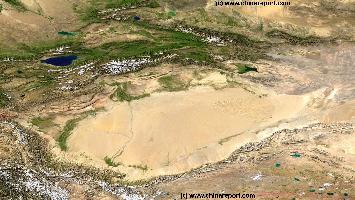
China Report - Map o/t Taklamakan Desert & Tarim River Basin
A Satellite Image Map of the entire Taklamakan Desert and the Tarim River Basin in Xinjiang-Autonomous Region of Western China.
Map gives explanation and backgrounds to Local Geography, the Flow of the Tarim River from the Pamir Mountains in the West to Lop Nur (Dry) in the East, ancient Oasis Cities of the Tarim Basin and Taklamakan Desert, the North and South Routes of the Silk Road in this Area, Past and Current Climate and Historic Backgrounds.
points at Damascus, Palmyra and Alleppo (in current day Syria).
Other Mediterranean Ports such as Alexandria and Tyrus likewise served as shipping points for Silks and other goods (See Maps of Silk Road!).
[ Back to Top of Page ]
Go to Top of Page !
NOVA's grand documentary - Find out new anthropological facts on the history of China, the Silk Road and the great migrations of early mankind.
Buy the Documentary now - Click Here !
The Desert Mummies of Mongolia, Qinghai and West China - Best Product !!
[ Back to Top of Page ]
Go to Top of Page !
Find out all the Basics and More on Mattheo Ricci, First Christian Missionary in China !
Source Book
"Maritime Silk Road"
( available from our Online Store )
Tourguides and Sourcebooks to The Forbidden City, at China Report Online Store
Source Book
"Ancient Chinese Inventions"
( available from our Online Store )
Modern History of the Silk Road :
1960's AD : Start of the Cultural Revolution Era in China. Vandalism perpetrated by 1960's Red Guards at Longmen Buddhist Caves near Luoyang, Henan Province.
March 2001 AD : The Taliban Muslim Fundamentalist Regime of Afghanistan robs its People of their Cultural Heritage by destroying the Silk Road Buddhist statues of Bamyan. On the face of a mountain near the city, three colossal statues were carved 4,000 feet apart. One of them was 175 feet (53 m) high, and on record as the world's tallest standing statue of the Buddha. The ancient statue was carved during the Kushan period in the fifth century AD. In the aftermath of this savage act of vandalism the world's earliest oil paintings were discovered in caves behind the partially destroyed colossal Buddha statues. The oil based paintings, possibly using either walnut or poppy seed oil, are present in 12 of
the 50 caves dating from the 5th to 9th century.

2) The Mastering of Silk Cultivation and weaving by European Craftsmen in Italy, spawning a rapidly developing and expanding silk production and industry in Europe itself. In the 13Th Century this knowledge and Wisdom spreads across Europe from Italy to Germany, France, Spain and Britain. By home production of Silk the international demand for Chinese Silks is lowered.
After the days of the Chin, the earliest Great Wall of China finally enabled successive Dynasties and Chinese peoples to conquer the West and thus open up the famed Silk Road, which would be the economic life-line for further development and contacts with the world. The silk road was won by the Han Dynasty, in a long and protracted conflict with the Xiong-Nu (later dubbed "the Huns") Tribes to the North in Mongolia. The Silk Road was developed further by the succeeding Dynasties, leading to the High Point of Trade and Cultural exchange during the Tang Dynasty (618 AD - 907 AD) Era. Ultimately, the Silk Road would remain crucial to Chinese Development, Culture and Economy until roughly the mid 14Th Century, when development of international overseas trading routes (the Maritime Silk Road), mutal hatred with Central Asian Tribes combined with the political situation in self absorbed Ming Dynasty China ended trade on the Silk Road by Imperial Decree.
the organization of Future combined uprisings in the West (Xinjiang) and East (Gansu, Ningxia, Shaanxi) simultaneously.

1877 : The name Silk Road, describing the network of trading routes across central asia is coined in 1877 by German geographer Ferdinand von Richthofen.

1890's/ 1900 AD : At the highpoint of the Colonial Era, European Silk Road explorers Sven Hedin and later Sir Marcus Aurel Stein explore the Silk Road paths of Central Asia. Hedin survives the sands of the Taklamakan Desert to refind the Lost Civilization of Khotan. In 1900 AD Stein makes excavations of the Khotan Site.

1890: Captain Hamilton Bower and Expedition explore the Northern Rim of the Taklamakan Desert, bringing back scriptures written on birch bark in an Indian Language.

1892 AD: A French expedition under leadership of Dutreuil de Rhins explores the southern rim of the Taklamakan Desert and later Tibet, where the expedition leader is murdered.
1717 AD: Dzungars of East-Turkestan invade the Nation of Tibet. Soon they start destroying Tibetan Monasteries and Cultural Treasures drawing outrage among the Population as well as a swift response from the nominally Buddhist-Lamaist Ching Court in Beijing. In 1718 AD a First assault by Ching Armies against the Islamic Dzungars in Tibet is repelled and defeated.

1720 AD: Islamic Dzungar Rulers of East-Turkestan are evicted from Tibet under the Reign of the Kangxi Emperor of the Ching Dynasty.

Between 1720 AD and 1730 AD the Dutch Adventurer Samuel van de Putte traveled from his Home in The Netherlands via Persia, India and Tibet to Beijing, after which he managed to make his return in the year 1730 AD.
Little is known about van de Putte's Journey, his motivations as oddly, the traveler refused to divulge to anyone what sights he had witness and who he had encountered on his historic and unusual Travels. Before his Death in 1745 AD he personally burned all his notes, diaries and evidence of the entire 10 year period, leaving but one rough map which provided data on the Route he had traveled.
The Map, preserved in the Netherlands, was destroyed in an bombing raid during world war 2.

1755 to 1757 AD: Ching Dynasty of China campaigns in the West with the aim of destroying the East Turkestan State and regaining the Western Territories once held by the Chinese. Independent East-Turkestan is violently subdued after the capture of the Dzungar Khan in 1755 AD. In the aftermath Dzungar Tribes fight for their lives against overwhelming odds. 70 to 80% of the Dzungars, some 500 thousand to 800 thousand individuals, are massacred in a campaign of ethnic cleansing and cultural annihilation.  The Dzungar, numbers exhausted, are finally defeated in 1759 AD, the remainder fleeing towards newly established Russian Territories to the North.
1644 AD - 1860 AD: The Ching Dynasty Interbellum - Regaining the West.
Asia Report - Maps - Distribution Islamic Faith Asia, Africa , Europe
- Click Map to view Full Version and further Information on Locations.
The End of the Silk Road comes due to a number of Factors, among which: 1) the emergence of faster more efficient Trans-Oceanic Routes for Trade, especially facilitated by the transcultural nature of the Mongol Empire and the integration of China into World Culture during the 12Th Century.
It would go too Far to discuss all the Details of this story, but finally Mankind could travel and Trade more widely. In the next period life-stock, gems, woven items and agricultural tools moved up- and down from West to East and Vice Versa.
Notably, among the first things to be traded was the knowledge of Bronze Melting and the primitive Art of Working.

This Art, beforehand developed in Western Civilizations, but as yet unknown in the Far East, is thought to have spread from Central Asia into China along these Routes. Archeological finds on Mummies of apparent European Descent in the Desert Graves in Xinjiang Autonomous Region (Khotan , Cherchen, Loulan and others) strongly suggest such an event.

The Gift of the Knowledge of Bronze Working would travel onwards to the East where in the succeeding period Han Chinese Civilizations based in the Yellow River Basin would develop the art of bronze working as never seen before. Although starting out late, the Chinese would become true masters of Bronze Working.

Around 2205 BC the Xia Dynasty of the Yellow River Basin saw the rise of the First Cities in History. Although very modest in size, the cities knew systematic agriculture and large irrigation works were initiated to till the land and prevent floodings.
The following Chinese of the Shang Dynasty and Zhou Dynasty (1121 BC - 255 BC) were the first to develop bronze-working to an already high level and they were the world leader in ceramics from their earliest invention.
To be exact, the Bronze Age started in China around 1500 BC.
The Birth of First Walled Cities was seen in the fertile Chinese Plains of Shanxi- and Shaanxi Provinces a first version of script appeared and for all practical purposes is was the beginning of recorded history in China (The Shang Dynasty Era left inscribed sea-shells and bones, evidence for the invention and development of primitive script in this Age).
15th century AD: Most of Central Asia converted to Islam.
The Landbound Silk Road trading paths become obsolete due to the advent of international shipping during the "European Age of Maritime Discovery". The Maritime Silk Road sees unprecedented traffic and trade.
Whichever way it was, during the earliest days of Civilizations in China, the western Hexi Corridor - China's Gateway to the West and a vital pass on the Silk Road - was already a vital conduit of People, Wares and knowledge. It was probably even before the very beginning of the Shang Dynasty Era that the existance of an Oasis Lake at JiaYuGuan underneath the Qilian Shan provided for the abundant watersource need to sustain an agricultural enclave or settlement that could support travelers from East and West.
1000's years later JiaYuGuan would become the End of China and the location of the Westernmost Fortress on The Great Wall of China (Chang Cheng), built in protection of the Chinese Heartlands as well as the vital economic artery of the ever developing Silk Road land trading paths.
Only when primitive script was invented, with some signs still recognizable in today's chinese caracters , the earliest histories started to be recorded.
Before this period not very much is known, other than through archeological finds and studies. There are however many legends of the period before script was developed, legends that the Chinese themselves regard as part of their true historic heritage.
According to legend, the foundations for Chinese civilization and what is now known as the Xia Dynasty, were laid by the Three Emperors and Five Sovereigns. Among these is the well-known Yellow Emperor, a leader an scholar also said to be responsible for the earliest foundations of traditional chinese medicine and who's Queen is said to have been the first to raise silk-worms and develop a primitive silk industry. Shen Nong, another of the Emperors is said to be responsible for creating the first primitive farming tools, such as the hoe and the wooden-plow. Whichever way it was, during the earliest days of Civilizations in China, the western Hexi Corridor - China's Gateway to the West and a vital pass on the Silk Road - was already a vital conduit of People, Wares and knowledge. It was probably even before the very beginning of the Shang Dynasty Era that the existance of an Oasis Lake at JiaYuGuan underneath the Qilian Shan provided for the abundant watersource need to sustain an agricultural enclave or settlement that could support travelers from East and West.
1000's years later JiaYuGuan would become the End of China and the location of the Westernmost Fortress on The 10.000 Li Great Wall of China (Wan Li Chang Cheng), built in protection of the Chinese Heartlands as well as the vital economic artery of the ever developing Silk Road land trading paths.

Only when primitive script was invented, with some signs still recognizable in today's chinese caracters , the earliest histories started to be recorded.
Before this period not very much is known, other than through archeological finds and studies. There are however many legends of the period before script was developed, legends that the Chinese themselves regard as part of their true historic heritage.
According to legend, the foundations for Chinese civilization and what is now known as the Xia Dynasty, were laid by the Three Emperors and Five Sovereigns. Among these is the well-known Yellow Emperor, a leader an scholar also said to be responsible for the earliest foundations of traditional chinese medicine and who's Queen is said to have been the first to raise silk-worms and develop a primitive silk industry. Shen Nong, another of the Emperors is said to be responsible for creating the first primitive farming tools, such as the hoe and the wooden-plow. The Third, Wu Xi, supposedly dedicated
Tombs in the Muslim Cemetery, Aktau, Kazakhstan
Tombs in the Muslim Cemetery, Aktau, Kazakhstan Photographic Print
Simon Richmond
Image: Rough Schematic Map of China, the Path of the Great Wall and its relation to Cities, Nations, Rivers and the Pathway of the Ancient Silk Road in China.
Chinese Ambassador Kang Ying (Gang  Ying)  is sent  west along the Silk Road on Mission to the Emperor in Rome (Ta-Ts'in) and re-establish the lucrative Silk Trade. Kan Ying's official mission reaches the head of the Persian Gulf. However, he is deliberately misinformed on the difficulties of travel to Rome and turns back. Parthians, who feared losing their middlemen function through developing contacts between China and Rome had interfered.

100 AD : After 400 Years of existence as an independent City Kingdom with its own Culture and Language, the City of Hotan (Hotien/Khotan) in the Western Taklamakan Desert (Xinjiang-Uygur AR) becomes a Chinese Tributary State, A Vasal Kingdom and Ally of the Han Dynasty.
1st c. AD: Kushan people (descendents of the Yüeh-chih) move to Tarim, introducing Gandharan culture to region.

68 AD: Han Emperor Ming Ti sends Cai Yin to the west; Yin returns with 2 Buddhist monks.

40 AD - 70 AD. Appearance of the Book Periplus of the Erythraen (=Red) Sea. A merchant handbook, written apparently by an Egyptian Greek, about trade routes through the Red Sea and involving both East Africa and India. It is one of the most important sources for Roman Eastern trade, compiled after the discovery of how to use the monsoon winds to make the round trip to India. The text Includes extensive information on ports and products.
The Lost Lake Lop Nur, The disappeared civilizations - The Complete DVD Set in Store ! - Click Here
Source DVD
"The Disappeared Civilization"
(available from our Store)
73 AD: Chinese general Pan Ch’ao (under Ming Ti) reconquers the Tarim Basin.

92 AD : Final Defeat of the Xiong-Nu Tribes by Han Dynasty Armies under leadership of Ban Chao and General Dou Xian. The Western Regions are made into a protectorate of the Han Dynasty.
Re-opening of the Silk Trading Routes through the West under the Han Dynasty.

97 AD :  With the Route to the West now re-opened,
Click Image to go to FULL Map Version !!
630 AD : In about 630 AD Hsüan-tsang (Xuan Zhang) travels through Lanzhou on the Yellow River and JiaYuGuan & Pass to Dunhuang, where he leaves the Jade Gate to travel along the Silk Road to India. The Journey is a dangerous, adventurous, interesting and perilous one. Among countries and sites visted: The Bedal Pass (Iron Gate), Kyrgyzstan and Uzbekistan, Bamian in Afghanistan, The Khyber Pass, then parts of today's Karakoram Highway and finally the Kashmir Region.
In India Xuanzang's Travels were also extensive. In pilgrimage he visited several of the places where important events in the Life of the (Sakayamuni) Buddha took place.
Many Years later and much the wiser on the religion of Buddhism he returned through Kashgar, Khotan and Dunhuang to arrive in 645 AD at Chang'An and meet a Heroes welcome. Xuanzang was to translate his Buddhist Scripture collection and become a Master of Buddhism, the founding Father, Professor and head Master of the Da Cien Si Temple of the Tang Capital. His Life, work and Legacy leave a unique and continuing impression on
Late T’ang-Ming Dynasties:

8th century AD: Islamic conversions begin to spread in Central Asia.
Chinese Culture and Civilization. In Xi'An Xuanzhang wrote the Hsi Yu Chi. In the aftermath of Xuanzang's Journey to the West the Tang Dynasty saw a popular rise of Buddhism and much political intrigue, all favoring Buddhism in Tang China.
The Caves of the Thousand Buddhas are heavily utilized by Buddhist monks, nuns, and worshippers, with considerable T’ang art work added.
Route Map of Xuanzang's "Journey to The West" (India).
1602 AD: Jesuit Missionary Bento De Gois (Life: 1562 AD - 1607 AD) sets out from Goa in India on a top secret mission with the aim of finding out whether or not the Nation named Cathay by Marco Polo is the same nation as China, which by then has been reached by Spanish and Portuguese Ships by overseas route. A secondary reason for the Mission, explaining much of its secrecy, is the intention of contacting the mythical Christian Monks of the Far East, as seem to reported in the writings of Marco Polo the Venetian.
After a 3 year long overland journey, during which the Missionary was disguised as an Armenian Tradesman, De Gois reached the far western end of the Great Wall of China. His arrival had proved that the land of Cathay Described by Marco Polo did in fact exist. It was also proven that this was the same Nation already reached by sea-born Traders and a Christian Mission including the now famous Matteo Ricci, which had traveled to Macau and knew it as China.
The Route traveled up to that point had been from Goa to Agra in India, then via the City of Lahore to Peshawar both in current day Pakistan, over the Hindu Kush and through Afghanistan to current day Kabul from where he was to pass over the Tian Shan Mountains and end up in Kashgar (Kashi), today the westernmost City in China. Kashgar at the Time however had fallen out of Chinese Control and was not part of Chinese Territory, thus the mission had to move further West to reach Chinese Civilization. From Kashgar Bento de Gois  headed to Yarkant where he waited for a while for the arrival of a large Trade Caravan, which he had heard was to travel further Eastward and into Cathay. By joining the Caravan De Gois had chosen to travel along the Northern Route around the Taklamakan Desert which led him through Aksu to Turpan, and then via Hami (Kumul) to the re-unification of the Northern and Southern Routes at the Oasis Town of Dunhuang. From Dunhuang it was only a short desert journey to the missions' primary destination, the Great Wall of China at JiaYuGuan.

Having traveled the treacherous path of the Silk Road to the Chinese Western Border De Gois was unable to travel further on to his secondary goal, the Imperial Court at Beijing.
Just some miles between the Magnificent Westernmost Gate under Heaven, the Jiayuguan Fortress, the Jesuit made a dire mistake which ultimately ended the Mission.

At Jiuquan/Suzhou, the administrative center of this far western district, De Gois inquired rather publicly whether the Nation he had just arrived in was China, Cathay or both. In so doing, he encountered a Trading Mission which had come from Beijing and was traveling West. De Gois got the answers he was searching for from this trading party, and, among things, learned that one of the Beijing Traders was personally befriended with Father Matteo Ricci, who had taken up residence in the Imperial Capital working for the Court.
The entire story however exposed De Gois as a Jesuit, a Christian and a Western Travel. His fellow travelers in the trading caravan would not respond kindly to this. After being heckled and ridiculed the fake merchant was robbed and stripped of most of his belongings. Having been thus humiliated, not much thereafter he found himself left stuck in Suzhou (now Jiuquan) as no one would take him further along.

Although De Gois managed to sent a notice of his dire situation by use of Beijing Trader as messenger to the Jesuit Mission now active in far Southern China and the leading Jesuit Matteo Ricci in Peking (1601 AD), communications were to say the least slow. The message arrived after one whole year.
Although the Jesuits in Beijing received his message and swiftly responded by dispatching a 1 servant rescue party to Benito De Gois. When the servant sent found De Góis at Jiuquan the tough old Jesuit traveler was already at the point of death. He expired in 1607 AD at Jiuquan, far away from any Christian Monks, Rome or the Peking Court.
Kahsgar - Kashi
1582 AD: In the year 1582 AD a small Jesuit Mission was sent by Sea from Goa (India), in an attempt to reach the Chinese Court. This Mission first reached Macau in China, after which the Inner Lands of Guangdong Province were reached the next year. Although this route of entry into China is not part of the land-bound Silk Road, the appearance of the first Jesuit Mission exemplifies the growing importance of the Maritime Trade Routes of the Era.
Where the Maritime Trade Routes had been scouted by Chinese Treasure Fleets, the Chinese Sea Power had evaporated in the early 15Th Century, and within 80 years European Ships- Portuguese and Dutch would follow their trail back to the Chinese Motherland.
500 BC : Ancient Greek Society becomes familiar with the knowledge of Silk and Silk Cloth. The Silk must have been traded from China along various long land-bound and overseas trade routes.
Not much later the Roman Empire starts its ascent. In Rome Silk Robes worn become a sign of the Aristrocacy. At Times, the prices of a Silk soar, making Silk more valuable than Gold in the Roman realms (300 BC to 300 AD).

333 BC: Alexander the Great of Macedon (Macedonia) (Life 356 BC – 323 BC) crosses into asia minor with an army of 40.000 Men and allied Tribes starting a  conquest that leads to the rapid
Wuwei, Gansu Province, China
1945 AD About half a Century after the Tours of the Great Explorers Sven Hedin and Aurel Stein another scholar, a British diplomat, a Cambridge Man and perhaps explorer the right honorable Professor Joseph Needham reached the trajectory of the Silk Road. Passing from Chongqing in Sichuan through a stop-over at Fengxian in Shaanxi Province and via Huixian in Gansu on to Lanzhou. To traverse the neglected and sometimes nonexistent road to the far west the Needham expedition traveled by army truck and reportedly visited the small peasant village of Shandan (where New Zealander Rewi Alley was dropped off), Jiuquan and JiaYuguan on the way to the famed Mogao Caves at the town of Dunhuang.
The journey made along the path of the Silk Road to Mogao would prove invaluable to Joseph Needhams later work, the worlds largest and most complete encyclopedia on the contributions of the Chinese Civilization to the overall development of world civilization. In its first few volumes the Joseph Needham revealed and proved how the Chinese had invented many things, centuries before anyone in the West had done the same. Among these, the movable block printing press, the magnetic compass, forms of hard iron, the first seismograph, methods of construction and many more inventions. Most notably, the finds done by Aurel Stein at Mogao in the shape of the Diamond Sutra, would provide the ultimate proof that the Chinese had invented printing centuries before a German Man named Guttenberg in the West had done so, as the Diamond Sutra is not hand-written, but block printed.
1661 AD: The Jesuits Grueber and D'Orville travel from Beijing via the overland Silk Route to Agra in India.
1829 AD: The German Geographer and Explorer Alexander von Humboldt embarkes on an expedition on the Silk Road. It is a Russian sponsored mission to chart the Western Sides of the Altai Mountain Range which today seperates Xinjiang-Uygur Autonomous Region of China from the nations of Kyrgyzstan and Uzbekistan.
Von Humboldt did write an offcial report for the Russian Government on his findings during the journey to the Chinese Border Regions, however -possibly due to the sensitivity of his Mission- he refused to divulge or write any personal accounts of it.
China due to the detail of his recorded observations, he is considered one of the International Explorers to first reveal and transmit the wonders of China to the West, in fact outdoing his near contemporary, Marco Polo the Venetian.
On his travels Ibn Battuta visited Vietnam before entering the Yuan Dynasty Empire of China through the Pacific Port City of Quanzhou (Zaitun), today located in Fujian Province. From Quanzhou -dubbed the city of donkeys- in the Book of his Travel accounts, Ibn Battuta followed the course of the Grand Canal through Hangzhou (Zhejiang Province) which, according to the accounts of Ibn Battuta, was the largest city in the world at that time. As described in the Book "The Journey" (or A Gift to Those Who Contemplate the Wonders of Cities and the Marvels of Traveling -  تحفة النظار في غرائب الأمصار وعجائب  الأسفاit ر ) took him three days to walk across the city. From Hangzhou, the journey led to Beijing (although there is some discussion on whether Battuta really reached Beijing, in his book he complements the City for its cleanliness).

1336 AD: Having never welcomed Monk Nicolas at Khanbaliq, in the year 1336, a group called the Christian Alanes who form an Imperial Guard in China send a message to Rome urging the Pope to name a substitute for the deceased Arch-Bishop of Khanbaliq John the Montecorvino. The message is received through a Genuese Merchant Andalo of Savignon, who according to
written records had traveled to Europe on behalf of the Mongol Emperor Toghon Temur (1333 AD - 1368 AD). A copy of a translation of the letter from the Chinese Emperor in Latin survives revealing further that Andolo de Savignon was but one person in a 15 member delegation sent from Khanbaliq (Beijing). In the letter the Khan asked for western horses and a counter delegation.

March 28, 1339 AD: A Papal delegation including the newly ordained third Arch-Bishop of Khanbaliq leaves from Naples in Italy on mission to Khanbaliq in North-China. Traveling through Almalik in Kazakhstan they hear of the murder of Bishop Nicolas and 6 other Priest by a band of fanatical Muslims 10 years earlier. The mission stayed at Almalik for nearly a year in order to restore the local Monastery established by the 1329 AD Mission Of Bishop Nicolas. After leaving Almalik in 1341 AD, the Papal Mission reaches Hami in current day Xinjiang-Uygur AR of China where they stay to convert the local population which consists mainly of Buddhists. The mission finally reaches the Chinese Court on August 29Th of the year 1342 AD where they are received by Emperor Toghon Temur in person, probably at the Shangdu Summer residence. The Emperor receives the one horse that survived the long journey.
Oddly, the new Bishop, one Nicolas Bonet, a Theologian from Paris in France, returns from Khanbaliq to Europe while the other Priest of the Mission remain in the East. Thus, Khanbaliq remains without its Bishop and is left with the the Legate John of Marignolli as leader of the Papal Mission.
The Europeans are very impressed with the Chinese Culture, science and administration.

26 December 1347 AD: The Papal Mission at Khanbaliq (Beijing) leaves the Capital of a crumbling Yuan Dynasty Empire by ship from the harbor at Quanzhou. Heading for India.

1362 AD: Mongolian Empire begins to decline. In 1368 AD China is finally lost to the crumbling Mongol Empire.
1368 AD: Ming Dynasty forces drive the last loyalist troops of the Yuan Dynasty and Mongol Tribes out of Chinese Territory via the JiaYuGuan Pass. The Ming Dynasty is officially established under the Hong Wu Emperor. In 1372 AD, the JiaYu Pass and Last Gate in the West on the Silk Road sees the beginning of the construction of JiaYuGuan Fortress, a citadel only completed by 1539 AD. Although the Silk Road is protected the Chinese Nation is overwhelmed by a dictatorial Dynasty that decrees an isolationist policy. Eventually the Ming will wind up closing land route to west, ending large scale operations on the Chinese Silk Road.

1372 AD: The City of Khara-Koto (in Inner-Mongolia AR), former Capital of Western Xia, now turned base of remaining Yuan Dynasty troops plotting to reinvade China is layed siege to by a Chinese Army. After a siege during which the Hei River is diverted away from the City and a desperate last Battle, the city is abandoned.
Full Documentary on Zheng He and the America's !!
1421 - The year that China Discovered America ?
Buy it at Movie Universe - Click Here
The History of Tea on the Silk Road - View the Book in the Online Store !
Source Book
"The Tea Road"
( available from our Online Store )
Source Book
"Peace Missions on a Grand Scale"
( available from our Online Store )
The History of the Ming Dynasty and the Great Mosque of Xin and much more ...
The early 15Th Century sees a renewed Rising of China under the remarkably ambitious Leadership of Ming Emperor Zhu Di (Yongle Reign), on who's orders the entire Nation embarks on a modernization and internationalization drive, the world has never before seen.
First arise the new Capital and Imperial City of Beijing,to which a renovated and Longer Grand Canal is connected to feed the Population of this City.
While the City is being constructed, a large fleet of ships -among which the so-called treasure ships, the largest wooden sea-going vessels in world history- sails from Chinese Ports to explore the Asian Oceans and Islands, the Indian ocean, Africa and the middle East and possibly beyond. The fleet is joined by allied Korean and Japanese Ships, diplomatic missions bring other smaller Nations into Tribute to the Chinese Crown and the First transoceanic trade routes are established leading to the
In 1421 AD the new City of Beijing was inaugurated in front of an international audience of rulers from a variety of Nations with whom relations had been established. The Chinese Emperor could claim to be the Central and Most Powerful leader of the Eastern World, however while its culture flourished to a historic highpoint, the nation strained under the weight of the financial and social costs.

1424 AD: Death of Emperor Zhu Di. Soon afterwards, an Imperial Decree orders the halting of all Maritime Missions, leaving the unprecedented Chinese Treasure Fleet to rot away. The ships never return to see there-after. Gradually, during the reign of subsequent Ming Emperors all international travel is forbidden. China locks itself way behind its Great Wall.

1453 AD: Not pursued by the Ming Dynasty Armies who have abandoned their strategy of forward defense, the Mongolian Tribes now re-united under the banner of The Northern Yuan Dynasty return to the borders of China and resettle the strategic Ordos Desert (today part of Inner-Mongolia AR).

1471-1472 AD: New Mongol Raids occur along the border of Ming Dynasty China, raising eye-brows at court in Beijing. It is an event that eventually will trigger the rebuilding of The Great Wall of China in western China, Ningxia AR and Shaanxi Province.

1473 AD: A Ming Army stationed at Yinchuan (Ningxia Hui AR) seizes opportunity and launches a raid against the Mongol Base camp in the Ordos Desert, annihilating families and there-after the returning Mongol Army. Immediatly there-after Chinese laborers start the construction of the Ming Dynasty Era Great Wall of China along the southern rim of the Ordos Desert and around the Ningxia plain.

1499 AD: By the year 1499 AD Portuguese Captain Vasco da Gama has made use of trade routes established by the Ming Tribute Fleet under Admiral Zheng He to find its way from the African East Coast directly across the Indian Ocean to India.
Click Map to Zoom and View Details
Beijing
Datong, Shanxi Province
Link: Satellite Image with Schematic of the Location and path of the Great Wall of China during the Ming Dynasty. Passes on the Great Wall included.
LuoYang, Henan Province
Xian, Shaanxi Province
DunHuang Gansu Province
Birth of the Maritime Silk Road. At the same time new initiatives are made by the Ming Court to stimulate trade along the landbound Silk Road.

Apart from the Construction of the lavish new Imperial Palace and City, the Grand Canal and the Treasure Fleet (leading to widespread deforestation, among places in Vietnam, Yunnan and Sichuan), large scale repairs and reinforcements were undertaken on the Great Wall of China. This last project intended to fulfill the vow of the Ming never to see the Mongols return to Rule China.
Book Hostels Online Now
Tianshui, Home of Maji Shan, Gansu Province, China
Everything about the Imperial Palace & the Last Two Dynasties !
Click Image to View Book in Online Store !
Source DVD
"Children of Huangshi"
(starring Chow Yun Fat)
( available from our Online Store )
The Needham Encyclopedia Book, Science and Civilization in China (SCC) published by the Cambridge University Press, today counts 7 Volumes, composed of 24 books and is still growing after the death of Needham , the original main author on 24 March 1995.
A view along the Central Section of the Mogao Caves Ridge, south-east of Dunhuang, Western Gansu Province. The Mogao Caves are famous for their unique cave art, documenting the shift from greco-indian buddhist art into destinctly Chinese forms more suitable to the local People and Cultures.
Shandong Province to write his travel accounts and descriptions of the earliest practice of Buddhism along the Silk Road. Apart from his valuable travel logue, Fa Hsien is most known for his pilgrimage to Lumbini, the birthplace of Lord Buddha. In fact, it was only using Fa Hsien's accounts that late 19Th Century historians managed to pinpoint the exact location of Lumbini and the parental Home of Sakayamuni, The Buddha.

432 AD: Nestorians outlawed in Europe by Roman Church; move to Persia and Tarim Basin, now part of China's Xinjiang-Uygur Autonomous Region.
The autobiography of Last Emperor Pu Yi, and more available from our Online Store !
Source Book
"Guide to Chinese Buddhism"
( available from our Online Store )
1908 AD - 1909 AD Russian explorer Colonel Pyotr Kuzmich Kozlov and his expedition travel in the Tarim River Basin, Inner-Mongolia and the Hexi Corridor, discovering valuable scriptures hidden inside a stupa at Kharakoto, the abandonned former Capital of the 13Th Century Tangut Empire (982 AD - 1227 AD). At the Mogao Caves at Dunhuang further Chinese and Tibetan scriptures are "gained". The scrolls and scriptures later provide a unique understanding of Tangut Civilization, language and culture.

1908 AD William Edgar Geil travels along the Great Wall of China from Shanhai Pass in the East to Jiayu Pass and Jiayuguan Fortress in the West. It is the first full length trip along the mysterious Great Wall by a Westerner. Geil 'discovered' the 'Eastern Fork' - where the two layers of the Great Wall in North Shanxi are connected, the Loop of the Great Wall of China through Eastern Tibet and many other smaller facts about the Great Wall unknown outside of China.  Through Geil's Book and Photographs the truth about the State and Lenght of China's mysterious Great Wall is 'finally revealed'. Not entirely, as later discoveries proved there was even more to the Wall then Geil discovered, the Han Dynasty Great Wall leading from Jiayuguan to Dunhuang and even beyond to Lop Nor.

1910 AD - A Uighur hunter named Ördek makes the First Discovery of the so called Xiaohe Tombs at Lop Nor in south-east Xinjiang of China (P.R.C.). The discovery of the Xiaohe (Little River) a bronze-age burial site, although not made public for another 24 years would open a brandnew chapter in Silk Road history and archeology.
1914-1915:  S.F. Oldenburg expedition brings mongol and chinese scriptures and documents from Dunhuang in Western Gansu Province.

1923 AD - 1925 AD: In the spring of 1923 twenty-eight camels, 6 horses, 4 Mongolian guides forming the backbone of the Wulsin expedition (under Aegis of the National Geographic Society in the United States of America) set off from Paotow (Baotou) on the Yellow River (in Inner Mongolia AR) on an unprecendented exploration mission through Inner-Mongolia and along Chinese parts of the Silk Road. During the two year long journey husband Frederick Wulsin records flora and fauna, wildlife and other natural features of the regions while Janett Elliot Wulsin documents it in around 1200 photos leaving unique data and images. The route followed leads through Inner-Mongolia, Ningxia, Gansu and finally East Tibet (Qinghai Province).
1906 AD - 1908 AD: Sven Hedin travels to the source of the Indus, Brahmaputra and Sutlej Rivers, and "discovers" the Trans-Himalayan Mountain Range.
1899 AD Loulan rediscovered by Svedish Explorer Sven Hedin, after being lost to history for a 1000 years. (Further discoveries at Loulan were made later by Hungarian Marc Aurel Stein in 1914 AD).
When Hedin reaches Lop Nor it has recently filled with water after a period of long droughts ended. Stein reaches Dunhuang and finds ancient treasures at the Mogao Caves of Dunhuang (Gansu Province) described earlier by Marco Polo. He and takes away 24 cartloads of ancient scriptures, including ancient Star Maps and the now Famous Diamond Sutra, which is a block-printed document.

1899 AD: A German expedition under leadership of Rudolf Hoernle returns from Central Asia reporting the finds of Indian Scriptures but of an unknown langauge at the site of abandonned Khotan.

1900 AD: Aurel Stein's first expedition in Central Asia travels through the Swat Valley and over the Karakoram Range to Tashkorghan (currently in Xinjiang-Uygur Autonomous Region of China). From there Stein moves eastward to Khotan for two weeks of excavations.
Be a 7Search.com Advertiser!
144 AD -173 AD: Kanishka, a powerful patron of Mahâyâna Buddhism, is King of the Kushana dynasty in India (their capital at Taxila, north of Islamabad, Pakistan).

166 AD: Han Emperor Huan formally introduces Buddhism to China in palace ceremonies.

166 AD:  Roman Emperor Marcus Aurelius sends out the first Roman envoy to the Imperial Chinese Court. The Mission departs by Sea from the Persian Gulf and successfully arrives South China. From there they travel overland to Chang'An (Xi'An).

After AD 220: Chinese control over Tarim Basin weakens as Hun invasions and local revolts widen; silk trade increasingly uses sea route but, 2 sites (Lou-lan and another near Niya River) provide evidence that the towns along the land route continued to trade and be influenced by East and West.
589 AD: Chinese regions reunite (Sui Dynasty).

618 AD -906 AD: T’ang Dynasty expands westward in a “forward policy” that spread its power farther into Central Asia than ever before.
4th-5th Century: Greatest flow of Buddhism to China, during Northern Wei Dynasty (386 AD - 535 AD).

397 AD: Chinese chronicle Taï-thsing-i-tung-tshi reports Khotan flourishing as a trade center.

399 AD to 414 AD: the Chinese monk Fa Hsien (Simplified Chinese: 法显, also Faxian, or Fa Hien) undertook the Silk Road journey from Chang'An (Xi'an) in China via Dunhuang
Click DVD Image to View Product in Store !!
Source DVD
"Journey in China - Yinchuan"
( available from our Online Store )
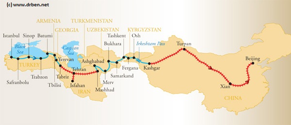
Map of the Modern Silk Road, connecting Istanbul in Turkey via highways, roads and railways to Beijing in the Far East. Travel beyond that point is possible to Vladvostok, Dalian and Dandong in Liaoning Province, or Pyongyang in North Korea, DPRK.
On the Western side, Istanbul connects via former Yugoslavia  to the European Railway network.
Click Map to go to Full Version !!
Overview of the Empire founded by Alexander the Great of Macedon (336 BC - 323 BC).
Turpan, Xinjiang-Uyghur Autonomous Region, China
Xining, Qinghai Province (East Tibet), China (PRC).
View the Land & Maritime Silk Road (of the Yuan Dynasty Era)
Asia Report - Map Roads & highways in Central Asian Nations
A geographical and topographical overview Map of the Central Asian Nations of (South) Kazakhstan, Tajikistan, Kyrgyzstan, Uzbekistan, Turkmenistan, and Parts of North Iran, North Afghanistan, North Pakistan, North India (Jammu & Kashmir), and the region of Kashgar (Kashi) in West China's Xinjiang-Uyghur Autonomous Region of
China.
Map includes International Borders, national provinces and regions (where possible), main cities and roads, main lakes and waters, as well as the locations of Historic Sites, wildlife reserves, officially designated ethnic autonomous communities, main mountain peaks with heights and more coming soon !
Browse the Map, click and follow the links to additional information on each site and location. Click on selected highlighted Map sections for a more detailed map of that Region. Explore the connections in central asia as never before !
1907 AD: In the spring of 1907 AD French Newspaper "Le Matin" (The morning) grabs the worlds attention and imagination by issuing an extra-ordinary challenge : Who will travel from Peking (Beijing) to Paris by motor-car this Summer? What is still hailed as the maddest motor-car race in human history was on.  Eventually the challenge is accepted by a team of 3 Italians, Prince Scipione Borghese, his chauffeur Ettore and one Luigi Barzini, the latter an experienced international journalist responsible for telegraphing back reports on the race and its progress. The route through Inner-Mongolia, Mongolia and Russia is known as the trans-eurasian trade route, the northernmost part of the larger Silk Road pathways.
(K)Hotan or Hetien, Xinjiang-Uyghur Autonomous Region, China
Turpan (Turfan), Xinjiang-Uyghur Autonomous Region, China (P.R.C.)
Beijing, Capital of China (P.R.C.)
Xian, Capital of Shaanxi Province, China (P.R.C.
Kashgar (Kashi), Xinjiang-Uyghur Autonomous Region, China (P.R.C.)
Rewi Alley's very own Story - the things that Matter ..
Source Book
"Rewi Alley - Autobiography"
( available from our Online Store )
Hami (Kumul), Xinjiang-Uyghur Autonomous Region, China
Shihezi, administrative Capital of Bayin Gholin Mongol Autonomous Prefecture, Xinjiang-Uyghur Autonomous Region, China
Aksu, administrative Capital of Aksu Prefecture, Xinjiang-Uyghur Autonomous Region, China
In the period 1929 to 1935 a lesser known Swedish explorer by the name of Folke Bergman (1902 AD - 1946 AD) traveled through the Xinjiang Region in order to record its geographical features and in the search of archeological remnants of the rich history of the regions and the Silk Road. During these exploits, while in the regions of the Lop Nor lake, the explorer was inadvertently introduced to a local Uighur hunter, one Ördek, who subsequently revealed to him a tomb site that had been discovered by him already in the year 1910 AD while working with Sven Hedin.
The site which Bergman was led to  is now known in archeology circles as the Xiaohe (Little River) bronze age historical site. As was in the following months well document, the neolithic site at Xiaohe in Lop Nor consisted of the clear remains of small and primitive settlement which also had an adjoining cemetery on a hill marked by circularly arranged wooden posts. The site was close to a river bed, which Bergman named Xiaohe, or “Small River.”, hence the current name of the site.
Today the cemetery attached to the Xiahe has been named the “Ördek’s necropolis,” in honor of Sven Hedin's Uyhgur guide who originally discovered the site.
When the news of the Xiaohe finds first made it out to a world audience raised considerable interest, especially among archeological specialist. However, the true depth of their meaning would only be revealed overtime.
As the adjacent video vividly illustrates, it eventually turned out that a fairly large and developed ancient Civilization had existed in the Tarim River basin. A Civilization that had existed long before the existance of the magnificent cultures of the earliest Silk Road, as they were recorded by the envoys of the Han Dynasty (206 BC - 220 AD). These had so far been the earliest recorded civilizations in the regions.
What was even more shocking and is a news that still reverberates around the world was that the mummies found incapsulated and preserved within their tombs were apparently not of Asian ethnicity but of a Caucasian origin. Among things some had red or blond type hair and blue or green eyes.
As various researcher teams have since established, the settlement and the associated cemetery belonged to the Gumugou culture, also known as the Qäwrighul culture, which itself was part of a larger civilization which had lived surrounding the Lop Nor lake and along the rivers of the Tarim River Basin (and what is not Taklamakan desert). Another “beauty” found in the region, a mummy known as the “Beauty of Loulan,” also belonged to this culture. Various other stunning finds have been made recently at Loulan, Yingpan, Cherchen and
YouTube Video: 6'6" Tall Mummies , describing the pre-Silk Road Aryan mummies found at Yingpan and Loulan.
other locations proving that as early as 2000 B.C. (when early Greek Civilization developed) a European type of peoples had been arriving from the far West (Iran, Iraq, the Black Sea and Turkey) traveling through Central Asia to the large Tarim River Basin fed by glacial rivers. There, they encountered Asian peoples with whom they intermarried and eventually build a Civilization with. As if all of this was not shocking enough, these peoples knew a primitive art of bronze working which is an art that was previously thought to have been developed in China independently from other parts of the ancient world. As historians now hold it, it is quite possible, if not increasingly likely that the migrations that occured on the Eurasian continent in the millennia before the birth of Christ and the advent of the Silk Road have carried the ancient knowledge of bronze working into China at that time. One of the routes through which this knowledge must have traveled is the Tarim River Basin, which sort of establishes a silk road of knowledge in existence long before the opening of the historic Silk Road as dated by the Han Dynasty scribes to the year 138 BC.
Cherchen (Qiemo), Bayingholin Mongol Autonomous Prefecture, Xinjiang-Uyghur Autonomous Region, China
Ruoqiang (Charkliq), Bayingholin Mongol Autonomous Prefecture, Xinjiang-Uyghur Autonomous Region, China