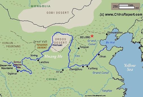
The Path o/t Yellow River through China (3) Lower Reaches
This page was last updated on: September 20, 2017
The Path o/t Yellow River through China (3) Lower Reaches
The Path o/t Yellow River (2) Middle Reaches - Gansu, Ningxia, Inner Mongolia, Shaanxi & Shanxi Provinces :
The Path o/t Yellow River through China (3) Lower Reaches - Henan and Shandong
The Path o/t Yellow River through China (1) Upper Reaches
The Yellow River is China's second longest river, measuring some 5464 kilometers (3,395 miles) in length. It is the world's 6th longest river.
The Yellow River is known in Chinese as Huang He and also as Huang Ho depending on spelling.
The drainage basin of the Yellow River, known as the Yellow River basin, is the third largest of all rivers in China, encompassing a surface area of around 750,000 square kilometers (290,000 square miles)(official: 742,443 km² (290,520 mi²).
It extends 1900 kilometers (1.180 miles) from West to East and 1100 km (684 miles) from South to North.
The China Report
YouTube Video: Introduction to the Yellow River - Note: a bit propagandaist.
Introduction to the Yellow River (Huang He - 黃河) - China's 2nd largest River
ChinaReport.comat
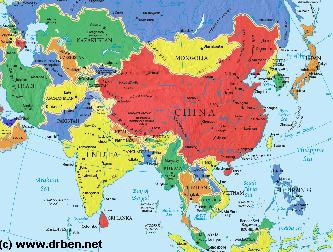
Asia Report - Map of Asia Entire . All Countries, Borders & Capitals
Full Geographical Overview Map of Asia Entire with Zoom & Scroll Functions, Relief Feautures, Oceans, Main Rivers and Capital Cities.
This Map of Asia includes all Asian Countries with Names & Borders, Disputed Border Regions in Asia, Capital Cities of all Asian Countries and Main Rivers & Mountain Ranges.
Anyang
Baotou
Hohhot
The Path of the yellow river starts in Tibet. On the modern Map it is found as a location in Eastern Tibet where a small spring originates from the foothills of Bayan Har Mountains in the extreme south of what today is known as Qinghai Province not far from the border with Sichuan Province.
To be exact, the river springs from the Northern Slopes of the Bayan Har mountains in the Yekuzonglie-basin at a height of +/- 4500 meters.
The source section flows mainly through pastures, swamps, and knolls between the Bayan Har Mountains (巴顏喀啦山脈) and the Anemaqen (Amnye Machin) Mountains, and can only be reached by riding Animal or with use of tracked vehicles. In this very early section the river water is crystal clear and flows steadily and is known as "river of the peacock" (Tibetan: རྨ་ཆུ་; Wylie: r Ma chu, p maqu 玛曲).
The two main lakes along this section are Ngoring Hu (also Lake Bob (扎陵湖) and Gyaring Hu (also:
Schematic Map of the Flow Path of the Yellow River through China.
Click Map to go to FULL Version !
Read More in: The Path of the Yellow River through China 1 through 3 - Upper reaches, Middle reaches and Lower reaches of the River.
Next the Yellow River flows into Henan Province, where it starts its last 1/3, the lower reaches at Kaifeng City and continues onward into Shandong towards the estuary of the River into the Yellow Sea.
The unusually large amount of mud and sand discharged into the river makes earning the Yellow River its name, make it the most sediment-laden river in the world. The highest recorded annual level of silts discharged into the Yellow River is 3.91 billion tons in 1933 and the highest silt concentration level was recorded in 1977 at 920 kg/m³. Most of the Loess silt deposits, around 95%, are derived from the middle reaches of the River.
Another problem on the yellow river occurs in winter and spring when the river freezes and defreezes, which in the past often led to 'ice-jamming' and subsequent floodings or diversions of the river. Because the river flows from South to North in its trajectory between the city of Lanzhou in Gansu Province and the city of Baotou in Inner-Mongolia Autonomous Region, cities with remarkably dissimilar climates and about 4.5 degrees different in latitude, these parts of the river do not freeze and thaw at the same time. In practise, the spring and thaw start earlier in the south in Gansu and Ningxia, where the thawing of the ice creates a higher flow of the water. At the same time, it is still freezing in the Gobi Desert and on the plains of Inner-Mongolia, so the river stays frozen in these regions. The breaking of Ice, pressed backward by the surging yellow river can lead to a natural build up of ice dams in the river, which then
divert the river into whatever is the lowest point near. If villages lie in the way, they are doomed to be engulfed by the waters.
Before the yellow river was first dammed in the early 1960's, this was a regularly occuring problem, which led to many wintertime disasters especially in the regions near the famous Gorges of the Yellow River in Gansu and Ningxia Hui Autonomous Region such as the Liujia Gorge, the Longyang Gorge and the Qingtong Gorge. The Yellow River does not only flood during the rainy season in July and August, but also floods in spring as a result of ice-jamming. At the present large infra-structure investments, shielding and damming have reduced the ice-jamming problem by about 80%. Some 688 kilometers of embankment in this section of the yellow river have been raised, and/or saw barriers erected or other types of flood control measures installed. Springtime flood disasters in this section are now predicted to happen once in every ten years.
Read More in: The Path of the Yellow River through China 1 through 3 - Upper reaches, Middle reaches and Lower reaches of the River.
Next the Yellow River returns to Gansu Province, where it starts its middle 1/3 section, i.e. the middle reaches at the border of Sichuan and Gansu Provinces. Next is a wild stretch with plenty of narrow gorges and some interesting modern and historical landmarks !
- Click Map to Enlarge to Full Detail Version - Follow the links to each Destination & Location !!
The Yellow River is usually divided into three distinct sections; its upper reaches, roughly one third that is also known as the Mountainous Section of the River. The Second
MAJOR TRIBUTARY RIVERS:
In the past, in the 2000 years that there were no bridges on the river, the large and often violent stream of the yellow river provided a huge obstacle to travelers, especially to those trading on the Silk Road. The crossing had to be done by boat -a luxury- , by floating across on a pork skin bag or on a raft made of these, or by finding a shallow and passable point. There but few, and in spring time when the winter thawed, all traffic was halted due to the torrent of ice sheets caried upon the surface of the river, turning it into a deadly trap.
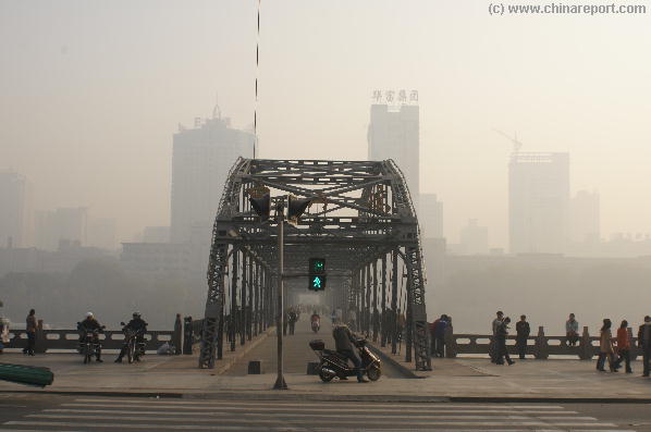
Not surprisingly, the First Bridge on the Yellow River in history was built exactly on the ancient crossing point of this trading thoroughfare and the yellow river. This steel bridge is the Zhongshan Bridge, built in Lanzhou in 1907 AD. Today there are many bridges to cross the river.
The Zhongshan Number 1 Yellow River Bridge in the center of Lanzhou in November of 2007.
The Famous Names attached to the Yellow River are as follows:
- George Hogg (1914 AD - 1945 AD) and the Children of Huangshipu
FAMOUS NAMES ATTACHED TO THE YELLOW RIVER:
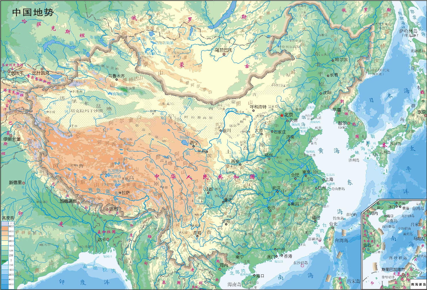
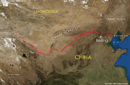
A Satellite image of China and East-Asia, with a super-imposed schematic Map of the location and Path of the Great Wall as constructed during the Reign of the Ming Dynasty (1368 AD - 1644 AD). Included for reference are City names, geographical features
of landscape, Names and locations of Passes on the Great Wall on the Great Wall of China.
Xi'An
Lanzhou
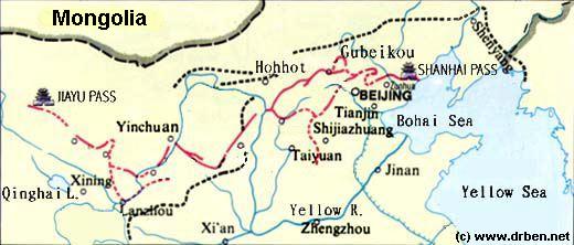
Schematic Map depicting the multiple layers of the Great Wall of circling Beijing and North and North-East China.
North-East and downstream of Lanzhou, along various gorges in the Loess Plateaux of the Region.
Zhongwei Great Wall Sections:
The Third site of interest is the location of Zhongwei in South-West Ningxia, where, after leaving the gorges of loess plateaux behind, the river quiets down and passes along the Great Wall of China, which in these parts was built between the river and the wilderness of the Gobi desert in Inner Mongolia (AR). At Zhongwei the river, the sand, the greenery and the wall combine into a unique scenery. At Shapotou at
Shizuishan Pref. - Dawukou Great Wall of China:
Sixth, the Yellow River passes through the Great Wall of China to leave China just North of the industrial city of Shizuishan in North Ningxia Autonomous Region. Today only a short ruined stretch of 50 meters reminds of the Great Wall that one stood inside the pass wheras as other remains stand in the shapr ravines of the Helan Mountains. Today's remnants are known as the Dawukou District Great Wall of China, but the correct name of the remains of the still recognizable wall between Helan Shan and the Yellow River is Jiucaigou. None of it can be seen from the river.
Liaonu Wan - Old Ox Bend:
The 7th and last place where river and wall meet is at the famous Old Ox (Liao Niu) bend of the Yellow River, where the 30 meter Wenbiling Xiao (Protecting the Water Tower) on Dongshan Hill stands overlooking the River. This tower is part of the Pianguan Pass Section of the Great Wall of China in Shanxi Province. It is a famous historical scenery, with many more remains of beacon towers and fortified towns in its wider vicinity.
Xining is located some ways North of the actual river. It is possible to travel from Xining down to the LiuJiaXia Gorge and hydro-electric Dam, which lie just across the border inside Gansu Province upstream from Lanzhou.
Lanzhou is the ONLY city in China through which the yellow river passes, dividing the city in two. In fact, the city of Lanzhou sprawls for several miles along the north and south banks of the yellow river inside a deep gorge of the loess plateaux. Zhongshan Bridge, the first bridge built on the yellow river still stands in Lanzhou today. Several larger ones have since been added.
Yinchuan is located on the West Bank, at some 15 miles from the River itself. Hengcheng is the traditional yellow river port outside of Yinchuan on the East Bank.
Hohhot lies many miles away from the River and is connected to it through the lesser city of Baotou. It is only mentioned for its relation to the river and for completeness.
Since the year 1852 AD when a devastating flood rerouted the yellow river in its entirety, Jinan lies on the south bank of the yellow river, but at some distance away from it. A giant modern highway bridge spans across the river above Jinan City, offering spectacular views of the river below.
FORMER IMPERIAL CAPITALS O/T YELLOW RIVER:
- Datong
Located in North-West Shanxi Province, not too far from the River Datong was the Capital of Northern China during the (foreign based) Wei Dynasty (386 AD - 534 AD) also know as the Tuoba Wei.
- Anyang
Located in North-East Henan Province, the city of Anyang used to be located along the yellow river until it flooded and was diverted to a more southernly path. Anyang was the Capital of China's 1st historically proven Dynasty, the Shang Dynasty (+/- 1600 BC - 1046 BC)(or 1766 BC - 1121 BC).
- Kaifeng
Kaifeng in Henan Province was several times over the Imperial Capital, or rather was the Capital of the later Liang Dynasty, the later Jin Dynasty, later Han Dynasty and the later Zhou Dynasty - all during the Five Dynasties and 10 Kingdoms period (907 AD - 960 AD), which occured after the demise of the succesful Tang Dynasty (638 AD - 907 AD). Kaifeng again became the Imperial Capital during the Northern Song Dynasty (960 AD - 1279 AD), when it was called Dongjing.
- Luoyang
The city of Luoyang in West Henan Province, was the Imperial Capital no less than 6 times in history, although little of it shows today. Luoyang was the Capital of the Zhou Dynasty (1036 BC - 256 BC), of the later Han Dynasty between 25 AD and their end in 220 AD, Capital of the Kingdom of Wei during the Three Kingdoms Period (about 220 AD - 280 AD).
Later Luoyang was the Capital of the Western Jin Dynasty (265 AD - 420 AD), of the Wei Dynasty (386 AD - 354 AD) after it moved Capital away from Datong and nearer to the vital Yellow River in the year 493 AD, and last it was Capital of the later Tang Dynasty during the Five Dynasties and 10 Kingdoms period (907 AD - 960 AD).
GRAND CANAL AND THE YELLOW RIVER:
The Grand Canal, histories longest man-made river, intersects with the Yellow River due south-west of Jinan, the Capital of Shandong Province.
WATERFALLS ON THE YELLOW RIVER:
There is only one waterfall in the entire length of the yellow river. These are the Hukou Falls
(Chinese: 壶口瀑布), located about halfway on the North to South stretch that runs between the border of (North) Shaanxi Province and Shanxi Province, shaping their respective borders. The Hukou Falls are the second largest waterfalls in China entire and as such are regarded as a major scenic spot.
Due to its awkward location in the Loess Plateau hinterlands, Hukou was once very difficult to access. After the local government constructed a major highway system to cut across the nation and built a highway bridge across the river, the number of tourists to visit the waterfalls rapidly increased. Numbers rose from 20,000 in 1994 to 100,000 tourists in 1996. Since, visitor numbers have only increased. Especially during National Holidays the Hukou falls are crowded out.
Their exact location is at: 165 km (103 miles) to the west of Fenxi City in Shanxi Province, and 50 km (31 miles) to the east of Yichuan (Shaanxi) inside Jinxia Grand Canyon. The width of the waterfall changes with the season, usually 30 metres (98 ft) wide but increasing to 50 m (164 ft) during flood season, according to the Yellow River Water Authorities. It has a fall of over 20 m (66 ft). Inside the Jinxia Grand Canyon the width is suddenly squeezed through a narrow gorge of only some 20 to 30 meters in width (66 ft - 98 ft) creating a forceful and magificent brown foaming torrent. The Hukou Falls itself is only about 15 meters (49 ft) high and some 20 meters (66 ft) wide, and its looks have been compared to the pouring down of brown water from a huge teapot. From this comparison the falls derive their name as Hukou (Chinese: 壶口瀑布 ; Flask Mouth) Waterfall.
GREAT WALL OF CHINA AND YELLOW RIVER:
HYDRO-ELECTRIC DAMS & PROJECTS ON THE YELLOW RIVER:
the Shanda Bend, the first watchtowers of the Great Wall once stood overlooking the river. The Zhongwei Great Wall of China itself stands out of sight of the river, right between the northern outskirts of town and the sandy Tengger desert which encroaches from the north- and north-west.
The Fourth Great Wall of China site to be found alongside the Yellow River lies within driving distance from Zhongwei in the western tip of Ningxia Hui Autonomous Region. It is a famous and well visited spot.
After flowing calmly through the winding curves found at Zhongwei and Shapotou (the latter being a noteworthy crossing point of the yellow river, where in the century before the fall of the Qing Dynasty (1644 A.D. - 1911 A.D.) there was a raft-pond, which could set small caravans and their loads across the river) the yellow river continues its path
Hengcheng Great Wall of China:
The next station of the Great Wall, number Five on our list, can be find immediatly due East of Yinchuan, on the Eastern Bank of the Yellow River. At the point known as Hengcheng, now a nearly lost name but in previous centuries the crucial and important location of the yellow river harbor that served Yinchuan, stands the western leg of the what is known as the Shuidonggou Great Wall of China. At the north end of the now barely recognizable village of Hengcheng stands a lonely eroded watchtower overlooking the Yellow River. This tower is the first one of only two watchtowers to stand overlooking the yellow river along its entire length.
Both the Shuidonggou Great Wall and the now fully modern remnants of Hengcheng Village are worth visiting when in the area. No one does, eventhough this is the beginning of the longest walkable section of the Great Wall of China (leading one all the way East to Yanchi) today, it is also situated along the gap previously used by the legendary Genghis Khan in his final revenge on the Tangut (Xixia) Peoples who once had their Capital at Yinchuan.
The village of Hengcheng today is partially an industrial zone and partially reserved for modern recreation. Accept for the Great Wall ruins nothing reminds of its grandiose and glorious history as the yellow river harbor serving this otherwise remote region. Throughout the centuries, many ships and rafts passed through the port of Hengcheng, carrying freight both downriver from Lanzhou, and up the river from as far away as Baotou in Inner-Mongolia. Today however, the river contains to little water in the summer seasons and it has also silted up. Only localized shipping, small fishing vessels and some patrol boats remain.
There are a total of three major hydro-electric dams on the Yellow River. All were built in the Mao Zedong Era (1949 A.D. - 1976 A.D.)
The first dam to be built across the river was the Qingtongxia Dam in Ningxia. Its ambition and purpose was trifold; to tame the river preventing flood disasters and gain better control for the use of water in the irrigation of the Ningxia Plain and agricultural development, while at same time generating the electricity needed to develop to regions industries.
Unfortunatly, almost since its completion problems have been reported for this dam.
The main problem associated with all hydro-electric dams on the Yellow River is the problem of silting, which is naturally caused by excessive silt load to which the river owes its name.
Lake Eling (鄂陵湖)), both containing crystal clear waters. These two high altitude and ultra-remote lakes are the first collection point of the many little streams flowing from nearby mountains. Beyond the lakes the waters travel as a first recognizable River although its waters are yet to take on the yellow colors the river is historically named after.
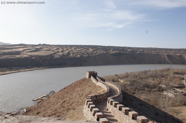
First watchtower of the Great Wall of China, a reconstruction on the original site - at the Shanda Bend of the Yellow River opposite the village of Shapotou in Zhongwei Prefecture of Ningxia Hui Autonomous Region. On the other side of the river one can clearly make out the first sand dunes that are part of extensive Tengger Desert, centuries ago the fringes of Mongolian territories. (Photos: December 2013).
northward to bend along the inside of the Yellow River.
Somewhere miles before the river enters what used to be the Xintongxia Gorge of the Yellow River and has been the the location of the hydro-electric dam by the same name, the Great Wall comes into view of the river on the left and western banks. This is the southern leg of what is known as the San Guan kou Great Wall of China, which continues northward alongside the river following the rising curves of the Helan Mountains (Helan Shan).
READ MORE ABOUT THE VARIOUS SECTIONS OF THE GREAT WALL OF CHINA PRESENT IN ZHONGWEI PREFECTURE TODAY IN: "ZHONGWEI GREAT WALL OF CHINA".
section starts upon the rivers' second entry into Gansu Province. From there onwards the river flows through its middle reaches, its longest section which trajects four provinces and two autonomous regions.
The Third and last part are the lower reaches which again cover roughly 1/3 third of the total length of the river. At Kaifeng the Yellow River meets the North China plain and flows slowly among levies to its termination point on the coast of the Shandong Peninsula.
The Great Wall of China encounters the Yellow River at several points along its length. Starting from the source of the river in Qinghai Province the first location where wall and river meet is along the Longyang Gorge in Eastern Qinghai Province (and South-West Gansu) between Xining and Lanzhou. This under-highlighted section represents the Great Wall of China deliminating the historical border with Tibet and the Tibetan Peoples.
More, even less visited and talked about sections of the Great Wall of China can be found East and
Major tributary rivers of the Yellow River are in order of appearance and by Province:
In Gansu Province; the Huangshui River - a major river which flows out of the Koko Nor (Qinghai Lake) Region of East Tibet to pass along the city of Xining before emptying into the Yellow River just upstream from Lanzhou.
In the city of Lanzhou the minor tributary of the Lei Tan He (Leitan River) joins. In addition the Black River or Hei He joins the Yellow River within Gansu Province.
In Ningxia Hui Autonomous Region; the Shuidonggou River joins with the Yellow River from the East and the Ordos Desert.
In Shaanxi & Shanxi Provinces; More than halfway down the length of the Yellow River where it forms the western border of Shanxi Province the Fen River joins the great Yellow River from the East . The Fen River is the
largest river in Shanxi Province bringing in heavily polluted waters from the cities and industries of Taiyuan, Linfen, Houma and Fenyang.
On the opposite (west) side of the river, lies Shaanxi Province from where the major tributaries of the Wei River and Luo River join the Yellow River. The Wei River is the main river flowing through southern Shaanxi Province Xi'An, the Capital of Shaanxi Province.
The Jing River - Jing He is considered another tributary, however it flows from North Shaanxi into the Wei River before both join the great flow at a slightly more easterly point.
Introduction to the History of the Yellow River (Huang He - 黃河)
An overview of the major and momentous events to take along the Yellow River and in the Yellow River Basin in North China throughout the history of Chinese Civilization.
CLiCK THROUGH TO:
More: (Offline) Sources on the Yellow River (Huang He - 黃河)
A listing of all (relevant) sources used in the creation of these pages. Suggested additional reading.