The Path o/t Yellow River through China (2b) Middle Reaches - Ningxia Hui Autonomous Region
The Yellow River is China's second longest river, measuring some 5464 kilometers (3,395 miles) in length. It is the world's 6th longest river.
The Yellow River is known in Chinese as Huang He and also as Huang Ho depending on spelling.
The drainage basin of the Yellow River, known as the Yellow River basin, is the third largest of all rivers in China (P.R.C.), encompassing a surface area of around 750,000 square kilometers (290,000 square miles)(official: 742,443 km² (290,520 mi²).
It extends 1900 kilometers (1.180 miles) from West to East and 1100 km (684 miles) from South to North.
The China Report
Introduction to the Yellow River (Huang He - 黃河) - China's 2nd largest River
ChinaReport.comat
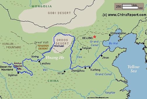
Schematic Map of the Flow Path of the Yellow River through China.
Beyond it the river flows through the Ningxia Plain, on the west side flanked by the Sanguankou Great Wall of China and on the other by the towering loess hills and peaks which rise up not too far from its banks. Originally connected to the Zhongwei Great Wall, the ruins of today's Sanguankou Great Wall of China follow the river upstream for over 80 kilometers before finding their terminus just beyond the 3 Gates Pass in the Helan Mountains. Before the river reaches the Helan Mountains however, it must flow through yet another crucial geographic feature. This is the historic Bronze Gorge
(Qing Tong Xia) of the Yellow River. Dammed in 1968 AD,
Yellow River in Inner-Mongolia Autonomous Region:
After passing through the 'Northern Great Wall' in Ningxia Hui Autonomous Region the Yellow River continues its course northward into Inner-Mongolia Autonomous Region. Within Mongolia the Yellow River is known as 'Hatan Gol', the Queen river.
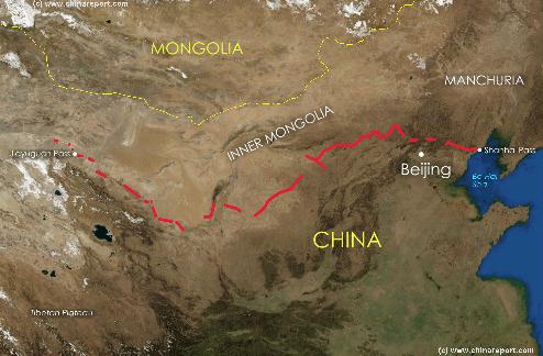
Overview of the Length and Path of the Great Wall of China of the Ming Dynasty. Includes links to Cities and Great Wall of China Passes. - Click Map for Full Version !
The total length of the Yellow River inside the Ningxia Plain is around 900 kilometers (560 miles), entering at Beichangtan in Zhongwei Prefecture and exiting via Huinong and Lasengmiao Towns of Shizuishan City Prefecture .
QINGSHUI RIVER:
The Qingshui River (清水河) joins the Yellow River from the South as a tributary between Zhongwei and Zhongning.
QINGTONGXIA - BRONZE GORGE:
Next the Yellow River meets the Bronze Gorge at Xintongxia. In history this is a famed location where the rivers waters were congested and thus speeded up before plunging and roaring through the narrow Bronze Gorge. The waters were known to be innavigable.
In modern times it is the site of the Bronze Gorge (Xintongxia;) hydro-electric dam (coordinates: 37° 53′ 11″ North by 105° 59′-XX″).
The Bronze Gorge Dam was built in the year 1968 AD and was hailed as a model of providing electric energy to such a remote region. Soon after its construction however the first problem with silting and sinking of the rich yellow loes deposits contained by the river in front of the dam. Much alike the recent situation with the renowned artist Ai Weiwei and the Olympic ″Bird′s Nest″ Stadium in Beijing , after the completion of the Dam, one of its original architects criticized the whole project
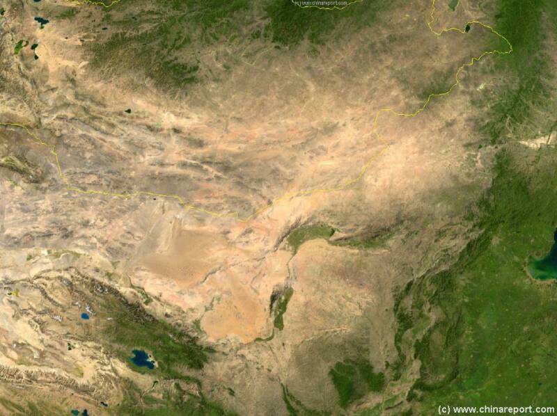
Satellite Image Map of the Entire Gobi Desert Region. Map overviews North-Eastern Qinghai Province, Gansu Province, Mongolia, Inner Mongolia Autonomous Region and North and North-Eastern China giving a Full Overview of the Gobi Deserts and a large part of the flow and path of the yellow river.
Yinchuan from where it is only some 50 kilometers to the Helan Pass into Inner-Mongolia and its historic Great Wall of China at Sanguankou (Helan Pass). Even more noteworthy are the so-called Helan Shan rock paintings evidence of early civilizations making use of the abundance offered by the Yellow River and its fertile plain.
Yinchuan, Ningxia's remote Capital is served by the yellow river port of Hengcheng. From this point the Yellow River used to be navigable upstream to the Bronze Gorge (Qingtong Xia) on the Gansu Border and downstream as far as Baotou in Inner-Mongolia AR. Today, this is no longer the case. However, river barges still ferry raw materials up and down the river over shorter distances.
As it so happens, the port of Hengcheng is also a location of the Great Wall of China. To be exact, the westernmost watchtower of what is called the Shuidonggou Great Wall - named after a small river that runs along its length later to add to the greater Yellow River - stands along the East Bank of the yellow river overviewing it.
After passing Yinchuan and the Great Wall of China at Dawukou (Shizuishan) the river once again meets the Gobi Desert Sands. This is the border with Inner-Mongolia, in the centuries past a dangerous zone where travelers found themselves exposed nomadic raiding parties, and worse: full scale invasions.
Soundbonus - Theme from The Great Yellow River (Film Documentary), by Kitaro.
Yellow River - Huang He : Menu
You Tube Video: China on the Move - the Yellow River in Ningxia - CCTV
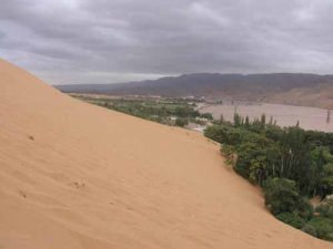
After leaving the Loess Plateaux of Gansu Province behind the Yellow River meets the sands of the Gobi Desert at Shapotou.
the Bronze Gorge (Qing Tong Xia) is now the Xintongxia Reservoir of the Yellow River and of vital importance to both agriculture and the electric energy supply in the wider region.
Where the Gobi Desert meets the Green of the Yellow River valley at Shapotou (沙坡頭) and Zhongwei the river slows down to a leisurely pace. Nearby is the Zhongwei Site of the Great Wall of China and beyond and around lies what is known as the Ningxia Plain (or Yinchuan Plain and Hetao Plain) of the Yellow River. Although surrounded by Sandy deserts and arid wastelands, this is one of the most important agricultural regions in China.
From Shapotou and Zhongwei the river gently curves northward flowing through the Yellow River plain which sits wedged between two desert regions. The Tengger, a sandy extension of the Gobi Desert in the West and the so-called Ordos Desert in the East.
The Great Wall of China, behind which it lay protected for the remaining centuries. Today, Ningxia is among the main destinations to go and see The Great Wall of China. Several sections dating from various eras can be found, Illustrating the gradual build up of Chinese Strength in the Region. The Great Wall of China has since shaped the official administrative borders of the Ningxia Region, and can be found swerving around the province from Shapotou in the South-West to Shizuishan, where the Yellow River enters Inner-Mongolia in the North. Apart from this main outer line of defense, there are several more layers scattered through Ningxia. In the South near Guyuan, and important Inner-Layer of the Great Wall of China blocks access to the important Wei River Valley, whereas in the East near Yanchi there is the Great Wall of the Qin Dynasty (221 BC - 206 BC), one of the oldest surviving sections of The Great Wall of China (Read more in 'Landmarks & Monuments of Ningxia Autonomous Region')
It is known that at the time of the Travels of Marco Polo, the entire region consisted of perpetually drying and flooding lands, many strips of which were fertile and usable for agriculture, interspersed with large swamps and many lakes. The entire plain was a giant green valley in between of otherwise forbidding climate zones and challenging geographies. Not only were there abundant fish, deer and game, the region was frequented by the most beautiful birds in all of China. This is a situation that remained until fairly recently, and only was threatened by the wild growth of population, immigration and ambitious agricultural plans launched not long after the establishment of The Peoples Republic of China in 1949 AD. The ecological costs of China's development as a Nation have since been fantastic, among things, in the Ningxia Plain of the Yellow River many of the Lakes and swamps have been filled in, mainly to be used for agriculture (Read more in 'History of Ningxia Autonomous Region (1 through 5)').
The result for the many migratory birds that frequented the region is that they can no longer find food, rest and nestling grounds. Another
Numerous historical sites dot this region. As is currently known, the first human beings lived in this region some 30.000 years ago, when they roughly picked this particular spot for its abundant water, wildlife and reasonable climate. The earliest remains of human civilization found in the region have been uncovered in the vicinity of todays regional Capital, the City of Yinchuan, in the North of the Territory. Today the Ningxia Region is especially famed for its primitive rock carvings, many of whom can be found within rock passages and passes leading west through the Helan Mountains into Inner-Mongolia Autonomous Region. Some, but certainly not all of the rock paintings date to this very early era, ranking among the earliest and oldest relics of Chinese Civilization. They are indeed national treasures.
Many 1000's of years later, after the Ch'In (Qin) Dynasty (221 B.C. to 207 B.C.) and Han Dynasty (206 BC - 220 AD) had wrested the fertile flood plain of what is now Ningxia from various marauding tribes and peoples in the West and North, the plain was finally ready to be cultivated, developed and included into the Han Chinese Empire. Not that it was not lost once or twice.
With its strategic location at the confluence of several natural barriers, and with abundant water and land for agriculture, the Ningxia Region soon became a highly disputed strategic border region. During the Han Dynasty Era already, Yinchuan became heavily militarized and the Imperial Armies were raising Horses in the grasslands of neighboring territories During the Tang Dynasty the current Capital became a city officially and was a fortress with a garrisson stationed in protection of these vital lands. Several times Ningxia fell under the influence and even autonomous rule of 'foreign tribes', perhaps the most glorious of whom where the Tanguts. Several relics of their once lost Civilization can be found in the Ningxia Region. Whenever the Han regained control, they set about solidifying their positions and strengthening the border. In this way, gradually Ningxia saw the rise of
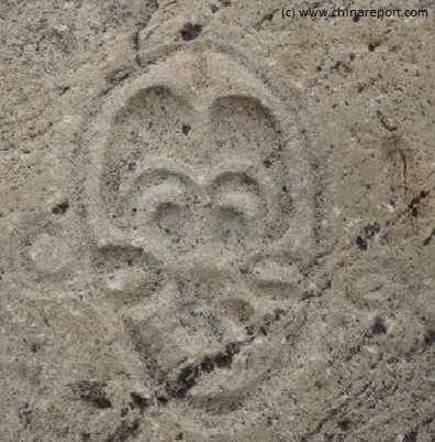
An ancient Face or symbol carved into a rock somewhere inside a Minor Pass in the Helan Mountains west of Yinchuan.
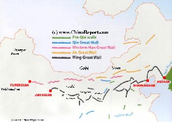
Map Great Wall China - Layers of Dynasties and Era's
A Schematic Map of China and East-Asia, with a super-imposed schematic of the various layers of the Great Wall of China.
Features Pre-Qin Dynasty Wall, Qin Dynasty Wall, Western Han Great Wall of China, the (Northern) Jin Dynasty Great Wall and finally the Ming Dynasty Great Wall as mainly remains today.
Main Features are Names and locations location of Passes on the Great Wall of China, outer layer and inner layer. Includes Shanhai Pass, Huangya Guan (Yellow Cliff) Pass, JiYunGuan Pass, Ningwu Guan Pass, Pingxin Guan, YaMen Guan Pass, Pian Guan Pass, JiaYuGuan pass, YuMen Guan Pass (Jade Gate) and Yang Guan Pass.
Further included for reference are City names, geographical features of landscape and main mountain ranges. Updates occur several times a year adding new pass locations and photo-virtual tours of Passes throughout China.
problem has been the over-consumption of ground water, again largely for use as irrigation and later also for industrial use.
Although today's regional government is going all out in attempts to restore some of the beauty and abundance of yesteryear, too much has already been lost. Besides, a new influx of migrants as a result of the Develop the West Strategy of the Central Government and introduction of new industries and people are sure to put more strain on Ningxia's resources and the Yellow River.
Although, several refitting's have made the dam better able to flush out the residue building in the reservoir in front of it, problems have always remained and today the dam does not run at full capacity.
Since 1968 additional minor and major dams have been built on the yellow river, its tributary the Hei River and other contributing waters contributing to the silting problem. In addition it often falls dry at the end of summers, for which reason the dam only produces around 1/3 of the electrical output it was intended to have.
Nevertheless, the dam has historically been a basic infrastructural need in order to provide electricity to each and every village within the Ningxia Region and even beyond.
One of the other main benefits from the dam has been that it has so far been very successful in preventing the phenomenon of Ice-jamming, which was a large problem in this section of the yellow river in earlier times.
ICE JAMMING:
When in winter, ice sheets pile high on top of each other driven by winds and the flow of the river, they can create large natural dams which in turn can create devastating floods. More frequently, come spring time when the river stars to swell,
all guide books but is one of the great sites of the Yellow River as well as the Great Wall of China.
It is not clear where the small Shuidong River connects with the Yellow River but one can travel north on the western bank of the river beyond Yinchuan City to visit the some of the last remaining wetlands of the Yellow River at the ominous sounding Sand Lake (Sha Hu). The Sand Lake is large green and lush area between Yinchuan and Shizuishan, and is recognized as the only remaining primordial lake in the middle reaches of the Yellow River.
Today a famous scenic area between Yinchuan and Dawukou, it provides a rare last refuge for wildlife and migratory birds in the Region. Although protected as a national level A1 wildlife park, pollutions of various sorts are rampant in this region. Especially the metal smelteries in the region and the coal fired electric plant at Dawukou are culprits which have been reprimanded by the (National) Government. In spite of the adversities the wildlife hangs on - drawing tens of thousands of nature lovers each year.
In extreme North of Ningxia (Taole County) a fourth tributary joins the Yellow River flowing in from the East. This is the Dustin Gol, a small river that flows out of the Ordos Basin.
This page was last updated on: May 24, 2017
My Great Web page
Just on the other side of the border within Ningxia Hui Autonomous Region the first name marked on the Google Map is Xiaweizikeng, however by all means, if there was a village there once it is now gone.
Thus, the first live village found along the Yellow River is Beichangtan.
Views of the crucial meeting point of the Yellow River, the Loess Plateaux and the sands of the Tengger Desert (Tengeli). Seen from the Shangda curve one can see the hills rising to the south west. Across the river, the first sandy dunes of the Tengeli appear just meters away from the river. Moving around the curve, the river meets the Shapotou Dune cut by the river into the desert after which it is deflected around (Photos (c) DrBen.com December 2013).
century ago the situation was somewhat different, on the north and west side of the river (almost!) northing but the endless sand dunes of the Tengger Desert greet any traveler. From the Yellow River it extends 100's of miles inward, until it merges with the larger Gobi Desert of Inner- and Outer Mongolia. On the other side of the river, the beyond the bend and on the northern bank lay a small agricultural village known as Shapotou, to which the place still owes its name today. It would have been as remote a community as was the village of Beichangtan upstream would it not have been for the little pont and the easy crossing of the river (during the summer and fall seasons). A few miles beyond, spawned by the Yellow River lay more villages which have sinced been merched into the Town of Zhongwei (still very much a collection of villages today).
The place where the Yellow River meets the first sands of the Yellow River is today known as the Shapotou Yellow River Scenic Zone. It ranks among the most popular tourist attractions of the entire Ningxia Hui Autonomous Region, and - during Chinese holiday seasons - is a well visited venue.
The Shapotou scenic zone is a fairly large and
extensive zone, which takes up large swaths of territory both north and south of the river. The parts of the scenic zone north of the River are separated by a railroad. To the north of the tracks lie the sand dunes of the desert, an area gratefully used by tourist for dune buggy and motorcycle rides. Although this area is supposedly world famous for its anti-desertification measures (the Shapotou Desert Research Station) not much is immediately noticeable of this.
BEICHANGTAN:
WHERE THE YELLOW RIVER MEETS THE GREAT WALL OF CHINA:
Inside the scenic zone, the north and south bank are connected by means of a long pedestrain hanging bridge which sways gently underneath ones steps.
On the South bank of the river, inside the Shangda wan (Wan = Bend), lies another large zone to explore. Among things it has a small watchtower offering a sensational view of the Yellow River coming from the loess plateaux. In addition, it has a small section of rebuilt Great Wall of China (not a replica) commemorating a section and a few watchtowers of the Great Wall of China which once stood at this remote and internationally very little known location. The imitation Great Wall overlooks the Yellow River looking down into its sandy gorge from the Shangda Bend.
Several layers and sections of the Great all of China can be found upstream near the Yellow River as it flows between Xining on the Qinghai Plateaux and the city of Lanzhou below in the loess regions. The next section historically to be found beyond Lanzhou is short and historically lost section built at the Shandawan. The function of this wall, if ever existed, must have been to serve as a flanking station for the larger and better known section(s) of the Great Wall of China arching north around what today is Zhongwei, a few miles inland from the Yellow River banks. Although the Zhongwei Great Wall does not overlook the Yellow River in any way but instead guards the desert on the opposite side of town, any amateur strategist may imagine how an enemy army might drive around, first to quench the thirst of their horses on the Yellow River, then refreshed - moving inland to threaten the rear of the Great Wall defenses.
Little or no information appears to be available on the history of the Great Wall in this location, but it may be noted that it once, in the 11th and 12th century, marked the border between Mongolian / Tangut Territory to the North, Tangut/ Tibetan Territory in the west, and Han Chinese held Territory (Song) to the south and east. Even today the border with Inner Mongolia Autonomous Region is not too far away, crossing from west to east just north of Zhongwei Town.
Beichangtan is situated at an altitude of 1535 meters, around 168 kilometers (104 Miles) north east of Lanzhou, and no less than 1045 kilometers (649 Miles) from the National Capital of Beijing. Considered ultra-remote, not very large and not connected to any road, the village of Beichangtan fairly much respresents the historic way of life as it used to be found along the river in the wrinkels of the loess plateaux. Beichangtan is built on a loess plain that has evolved from a bend in the Yellow River, thus creating a small niche where agriculture through irrigation is fairly easy, and the life of a peasant can thus be fairly comfortable. As ancient as anyone can tell, the old village resembles a green oasis in the desert lying between the brown of the river and the nearly barren hills of the loess plateaux towering above. In between stand 1000 year old fruit trees producing locally famous peaches and other fruits. Increasingly connected to the outside world, the villagers are considered fairly well off and it remains a popular place of residence where no one intends to move away from. Around the beginning of the year 2014 a new road is planned to be completed, finally connecting the ancient riverside village with the nearby villages and market towns ending a 1000 year long seclusion.
Traveling further north-eastward from the Bend at Beichangtan, the river continues in a slow but steady pace to meet its last barrier before reaching the Ningxia Plain. This is the Chahekou (-- River Gorge), an ancient name to which it can still live up to. The Chahekou is found amidst a wasteland at some distance south-west from Shapotou and the Shapotou Scenic Zone. Otherwise non-descript it forms the last narrow Gorge of the Loess plateaux before allowing the Yellow River to flow into the Ningxia Plain.
Next, immediately after breaking free from the sandy hills of the loess plateaux the Yellow River meets the sandy Tengger Desert which blocks it progress further northward. Forced into another large bend, the Yellow River curves eastward and then curves back around until it heads due northward.
The location of the Bend, once an ultimate corner of the Ningxia Region (Province), represented a connecting node (intersection) of camel and cart pathways and, until well after the advent of the Peoples Republic of China in 1949, was famous crossing point of the Yellow River. Although as much as a
(now the district of Wuzhong City) built not too far upstream from where the dam stands today on a fertile plain known as a troublespot and bottleneck on the river. It had not been the first time the village had been wrecked.
The Government claims that since the completion of the dam in 1968 AD 80% less ice-jammings have occured, they do however still cause problems along the river each spring when the river swells.
The Qingtongxia dam itself is a long and straight dam which reaches right across the river at this fairly narrow point.
The Kushui River, another tributary joins the Yellow River between Daba and Yesheng Towns, just North and downstream of the Bronze Gorge Hydro-electric Dam and near the largest bridge across the river in the region.
At this point an extra 4 smaller dams were added to cross the river and regulate the outflow as well as to provide a pressure reservoir for irrigation purposes.
The largest Bridge on the Yellow River in Ningxia is the Taole Yellow River Expressway Bridge (陶乐黄河大桥) which is located some ways south of the regional Capital Yinchuan near Xingtongxia and Litong.
A second recently constructed bridge is the Zhongning Huanghe Highway Bridge, a part of the Jinzhang Expressway in South-West Ningxia. In total Six highway bridges have been built to arc across the 397-kilometer section of the Huanghe
River flowing through Ningxia, averaging one bridge on every 66 kilometers of the river course. Currently construction of the seventh bridge is under way.
HELAN SHAN - HELAN MOUNTAIN RANGE:
At about 2/3 through the Bronze Gorge Reservoir the great river arrives at Helan Shan (賀蘭山), a high mountain range which serves as natural barrier that protects the Yellow River from the encroaching sands of the Tengger Desert.
Underneath the steep ridges of these Mountains on the Western bank lies Ningxia Autonomous Region's Capital City of
meter thick ice still covers the river. When thaw comes and the ice breaks up, the shards pile up at certain points along the river creating partial or complete blockings of the river.
Naturally, in the event this occurs the levels of the water immediately upstream may rise rapidly and where no dykes are available to hold the waters back the river may choose a new course and flood the land. It happened many times over the past centuries, especially in the low lying and thus vulnerable Ningxia Plain.
In 1904 AD one such flooding at the Bronze Gorge wiped out half the town of Lingwu