Parts of Ningxia Hui Autonomous Region have been inhabited for many 1000's of years however the first recorded settlement in this area date from the Han Dynasty Era (206 BC - 221 AD). During the first Century BC the first irrigation networks were built along the length of the yellow river sustaining the first settled Han population in this region.
As described above, the parts of Ningxia south of the Yellow River (Huang He) were incorporated into Chinese Territory and its cultural sphere by the Qin empire in the 3rd century BC, at which time a first version of The Great Wall of China was built in the Ningxia Region. They failed however to hold their ground in the remote and exposed river plains. Hence, a Great Wall was built to protect the more central regions of the Empire from Nomadic Raiders.
This first 'wall' was by no means continuous but it provided several military strong-points from which to patrol, deal with raiders and give early warning of invading armies. One Garrison was stationed at Yinchuan which was later turned into a fortified walled City. Still others were stationed at Yanchi and Dingbian, with another Fortress 100s of kilometers to the East at Yulin in Shaanxi Province.
The Irrigation canals on the Northern plains of the Huang He are held to have been first established during the short-lived unification of China under the Qin Dynasty (221 AD–207 BC), after which during the Han Dynasty (206 BC–220 AD) a full canal system to irrigate the plains around Yinchuan was developed. In fact, it was under the harsh but visionary rule of Emperor Wudi of the Han
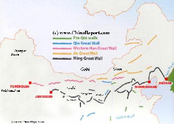
Map Great Wall China - Layers of Dynasties and Era's
A Schematic Map of China and East-Asia, with a super-imposed schematic of the various layers of the Great Wall of China.
Features Pre-Qin Dynasty Wall, Qin Dynasty Wall, Western Han Great Wall of China, the (Northern) Jin Dynasty Great Wall and finally the Ming Dynasty Great Wall as mainly remains today.
Main Features are Names and locations location of Passes on the Great Wall of China, outer layer and inner layer. Includes Shanhai Pass, Huangya Guan (Yellow Cliff) Pass, JiYunGuan Pass, Ningwu Guan Pass, Pingxin Guan, YaMen Guan Pass, Pian Guan Pass, JiaYuGuan pass, YuMen Guan Pass (Jade Gate) and Yang Guan Pass.
Further included for reference are City names, geographical features of landscape and main mountain ranges. Updates occur several times a year adding new pass locations and photo-virtual tours of Passes throughout China.
In 221 BC the 'Warring States' of China were united under the Banner of the Last Man Standing, Emperor Ch'In Shi Huangdi, the Man after who China was named. During his Terrible Reign construction was started on what has long been regarded as the first-ever-version of The Great Wall of China.
As is famously hailed in documents and writings of the Time the Great Wall of Qin resembled a gigantic dragon, extending from Lintao in the west to Liaodong in the east. Thus it was named 'Wanli Changcheng' (Ten Thousand Li Great Wall).
To be exact the Qin wall wound it way across the continent from present day Min County in Gansu Province, winding through Inner Mongolia eastwards to end as far away as in Tonghua County in Jilin Province on the current North-Korean (DPRK) Border. Thus it included the extreme southern parts of today's Ningxia within the Empire and sections of Qin Wall remain there.
During the shortlived Qin Dynasty (221 BC - 206 BC) Chinese armies held territory in the Yellow River valley in current day Inner-Mongolia building both fortresses and sections of a Great Wall there. Qin territory reached as far West as the western bend of the Yellow River (today:Resounding Sands Gorge). Ningxia however was not consolidated as part of the Qin Territory.
Although there were several attempts to expand the Empire towards the north and north-west, the Qin Armies were unable to permanently defeat the mobile Nomadic Tribes which roamed in every hungry winter, destroying crop and killing the livelyhood of the farmers. Thus the Qing rarely could hold on to the land for long. At first, the Yellow River plain around today's Yinchuan was conquered and setlled during the Qin Dynasty (221 B.C. - 207 B.C.), however once a settlement was established, it became a target for the hostile Nomadic Tribes of the Region. The tribes of these regions, collectively called the Hu by the Qin, were independant 'Kingdoms' who were prohibited from trading with Qin Dynasty peasants, by Imperial Decree. They were barbarians, held to be unworthy to share in the greatness of Han Chinese Civilization. As a result: the 'barbarians', often in need of grain in winter, looked in envy at the Han farmers stockpiles, and according to their custom resorted to plundering the Qin Settlements for booty. The Xiongnu tribe, living in the Ordos region in northwest China and north of the Yellow River in Inner-Mongolia were especially notorious raiders often prompting the Qin to retaliate in a tit-for-tat fashion. When after several lenghty military campaigns and much bloodshed and effort, the northern Ningxia Region was finally conquered and agriculture established, the peasant-settlers who were basicly left to their own devices in these remote region with sparse communications grew discontent, and later they revolted undoing all works.
The (middle section) Great Wall of China of the Qin Dynasty therefor lay outside of the Yellow River Bend along the Lang Shan and Yin Shan Mountains in Inner Mongolia AR. The (Western section of the) Qin Dynasty Great Wall included a small part of southern Ningxia and remains of the Qin Wall can be found near Guyuan.
In the past many people, including the Chinese, held the believe that it was Emperor Qin who first ordered construction of Defensive Walls along important borders. But since research of historical records and actual wall section showed that before Qin's Great Wall, the six ducal states of the so called "Warring States Period (475 B.C. - 221 B.C.)" had already built their own walls to prevent attacks from each other and the Huns. Thus the Great Wall of the Qin Dynasty was built by connecting sections of defensive walls built earlier by states conquered by the Q'In. It is now known that the ducal states Qin, Zhao and Yan were included in the Qin Great Wall, and that several thousands of miles of the Great Wall of Qin were constructed by an army of convicted slaves under guard of the Qin Army.
Initially, the Xiongnu neighbors which dominated the eastern Eurasian Steppe, had defeated the Han in a huge battle in 200 BC. Following this defeat a political marriage alliance was negotiated in which the Han became the subordinaries of the Xiongnu, paying tribute for their mercy.
When however the Xiongnu continued to raid Han borders regardless of the treaty, Emperor Wu of Han (Reign: 141 B.C. - 87 B.C.) launched several military campaigns against them in Ningxia and Inner-Mongolia. The new war was succesful for the Han who then forced the Xiongnu to accept vassal status as Han tributaries.
These victories were especially important since the capture of Ningxia enabled later campaigns westward expanded Han sovereignty into Gansu, the Hexi Corridor and beyond into what is now Xinjiang-Uygur Autonomous Region. The Han Dynasty Great Wall ended at Lop Nor in Eastern Xinjiang whereas Han Military Campaigns reigned as far as the Tarim Basin and planes of Central Asia. All these military conquests, expeditions and alliances in the far West then helped establish a vast trade network that was very useful for the export of Chinese Goods and later became widely known as the Silk Road. This 'Route' reached from the Chinese Capital, at the time the
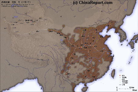
Map of the Han Dynasty Empire (206 BC - 220 AD) at its highpoint. Clearly visible on the Map are the outlines of Gansu Province and the Strategic Hexi Corridor leading West. Current day Ningxia and the entire Yellow River Basin are in Han Chinese Hands.
Yinchuan
During the ensuing Time of the Han Dynasty Chinese Military pressure, espionage and political plots managed to help inflame political strife among the Xiongnu who ended up divided into two competing 'nations' of allied Tribes, the Southern and Northern Xiongnu. Making use of the resulting military weakness the Han managed to gain much territory and drove the Northern Xiongnu across the Ili River (today in South-Eastern Kazakhstan).
Despite these Monumental Victories, the territories north of Han's borders
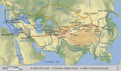
Rough Schematic Depiction of the Trans-Eurasian Trade Routes that later became known as the Silk Road. The first Routes to the West were opened during the Han Dynasty Era (206 BC -220 AD).
were quickly overrun by a new unified group of Nomads, the so-called Xianbei Confederation.
Ningxia fell out of the control of the Central Han Chinese Empire after both the Han and Tang Dynasties but, as a fertile and strategic region, was always reconquered and included within the defenses of the Great Wall of China. The Nomadic Tribes of Mongolia and Central Asia would remain China's mortal enemies for another 1000 years or more.
largest City in the World, across the continent as far as the Mediterranean Sea and the City of Rome, capital of the Roman Empire.
Dynasty (206 B.C. - 220 A.D.) that a first settlement at the location of today's Yinchuan City was established. The slave-workers army of settlers sent into the regions by Han Wudi (Reign: 141 B.C. - 87 B.C.), an estimated 2 million people (roughly the entire population of wider Mongolia at the time), built what was named Beidiannong City (in sources it is also named Lu City or Yinhan City) and this settlement became the earliest forerunner of Yinchuan City. The city and the irrigation system constructed by during the Han Dynasty Era survived for a 1000 years and the ingenious canal system still served as the basis for agriculture when during the Tang Dynasty (618 AD–907 AD) the area was further settled and developed by Han Chinese filling the plain with Chinese Farmer-settlers and their villages. Ningxia first became an administrative region of a Chinese Empire during the Qin and Han dynasties, when it was known as North Prefecture.
Ningxia is one of the cradles of Chinese civilization. It has been proven through excavations, finds and study of the ancient rock carvings on the Helan Mountain Plateaux that human activities already existed in the Ningxia Region some 30,000 years ago.
Furthermore, out in the desert due East of Yinchuan, underneath its eroding Shuidonggou Great Wall of China even more fantastic finds were done. In the period between 1919 and 1923 A.D. the first ancient findings included stone age relics dating to well over a 100 thousand years ago and fossilized bones dating to the same period. Then, upon further inspection by archeological teams a complete ancient civilization of hunter-gatherers with surprisingly early european caracteristics was identified. As archeologists and historians have since established, even in the stone age, the Ningxia Plain was already a favored place for living and settlement, the bounties of the fertile soils deposited by the Yellow River enabling easy living and development of stone age man in these parts. It was also established that at that time already the location of Yinchuan was a crossroads of cultures. That is, it seems that they later stone age (neo-lithicum) finds show caracteristics of both asian and european primitive cultures.
Other archeological finds have established important facts about the earliest Chinese Dynasties, the Shang (disputed: +/- 1600 BC - 1046 BC) and the Zhou (1045 BC - 256 BC). During the so-called Warring States Period (of the Zhou Dynasty) (476 BC - 221 AD) Ningxia was not yet part of the (Han) Chinese Cultural sphere or territory.
Regardless, people lived there, practised agriculture and trade as astounding archeological finds done in the Region have shown. Among things, it is proven that trade between Ningxia and far away parts of Central Asia already took place long before the official opening up of the Silk Trading Route during the Han Dynasty period
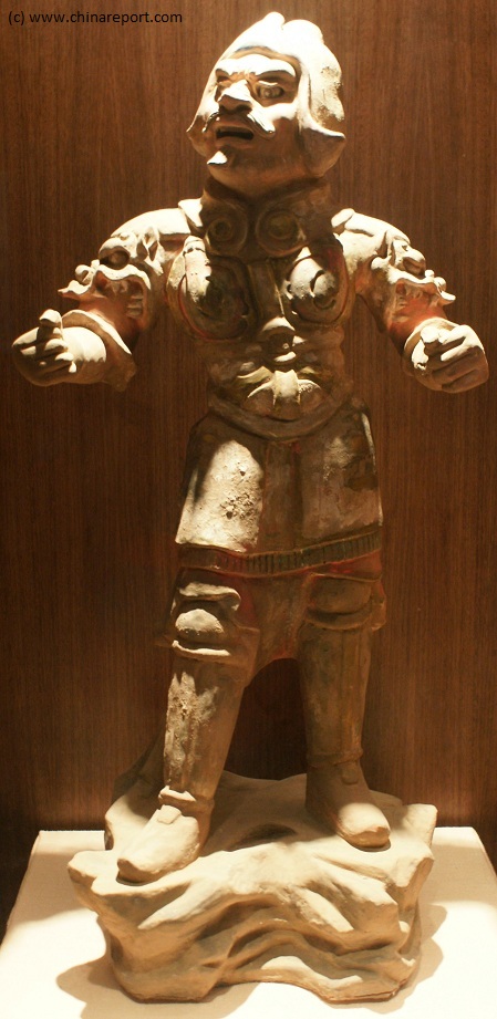
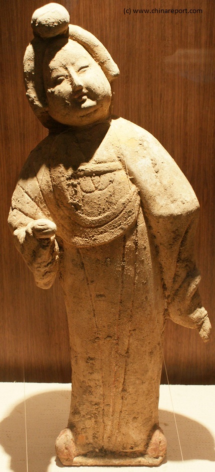
Colorglazed ceramic statues typical of the Han Dynasty Era (206 BC - 220 AD, excavated in the region of Yanchi, East Ningxia just inside the Great Wall of China and on display at the Ningxia Provincial Museum in Yinchuan.
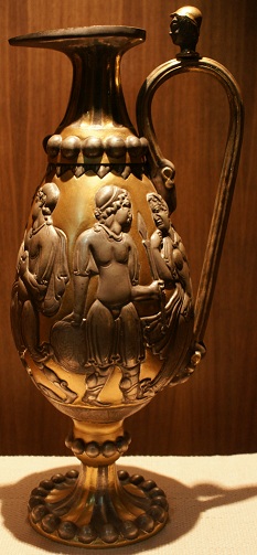
Bronze wine pouring vessel with clear Greek feautures as part of the collection of the Ningxia Provincial Museum, Yinchuan.
in Chinese History. Among the finds now on exhibit in the Ningxia Provincial Museum in Yinchuan are gold and copper coins dating to the Acheamenid Persian Empire (550 AD - 330 AD) and the Seleucid Empire (213 BC - 63 BC). An astounding intricately worked bronze wine pouring vessel created in what is clearly a Greek style was found just beyond the Ningxia border within Inner Mongolia raising questions of trading links and possible diplomatic contact between the peoples of Ningxia and those beyond the Tian Shan (Heavenly Mountains) west of Kashgar, which is where the ultimate eastern border of the Seleucid Empire was located. The Seleucid Empire appeared from the rubble of Alexander the Great's continent wide conquest, which is the only logical explanation for the appearance of Greek Art within these far flung regions. So far however, this is the only archeological evidence uncovered. The bronze wine pouring vessel is especially unique. It is part of a set of two found inside a tomb. The other one is damaged and currently in the collection of the British Museum in London.