Surface Area of City Prefecture (Municipality) of Kabul: No Data.
Urban - no information available.
Population of Kabul : No Data.
The city today known as Kabul - no information available.
AfghanistanReport.comat
Although Kabul today is not one of the Greater World Metropolises, there are plenty of Landmarks and Monuments to visit and marvel at.
Public Transport in Kabul City ( and Afghanistan)
MAIN TRAIN STATION OF KABUL:
Kabul City train station - no information available.
No information available.
VISA ARRANGEMENTS FOR THE REPUBLIC OF THE AFGHANISTAN:
No information available.
ESSENTIAL TRAVEL WARNINGS / NOTIFICATIONS:
Prohibited items in Afghanistan include - No information available. Passengers should confirm with their airline of travel for further information and refrain from risk seeking behavior.
No Information available at this Time.
No information available.
No Information available at this Time.
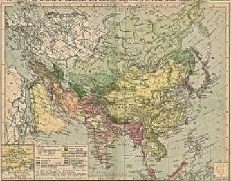
China Report - Colonialism - Growth of Colonies & Japan after 1801 AD
A Map drawing of the Eurasian continent , parts of North-East Africa and the Middle East in the 19Th Century between 1801 AD and 1900 AD. Focal points are the expansion of western colonial posessions of Portugal, Britain and France, as well as Russia moving from West to East. Labeled seperately is the later Rise of the Empire of Japan in the East.
Included in this Map are the main cities across the continent with their brief histories and events during the 19Th Century. Marked in Colors for clarity are the various colonial and imperialist Nations. As relating to China; special attention is payed to so called Treaty Ports. The First Treaty Ports were forced open by Britain in the year 1841 AD, but counted over 80 in total by the end of the 19Th Century. The most important Treaty Ports in China are marked and described with a short history where the map allows.
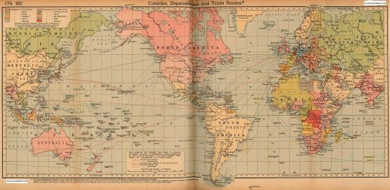
Colonialism - 1912 World Map of Colonial Possessions & Trade Routes.
A Map drawing of the World depicting the Colonial Possessions as they were distributed in 1912 AD. Superimposed and marked in colors are subsequent changes in Influences Spheres, colonies and possessions due to World War I ( 1914 AD - 1918 AD).
Included in this Map are the main cities across the continents with their brief histories and events during the late 19Th Century and early 20Th century, where relevant. Marked in Colors for clarity are the various colonial and imperialist Nations. As relating to China; special attention is payed to so called Treaty Ports. The First Treaty Ports were forced open by Britain in the year 1841 AD, but counted over 80 in total by the end of the 19Th Century.