This page was last updated on: November 27, 2011
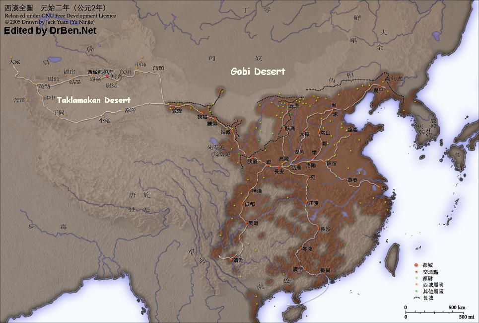
This Historic Map Image depicts China at the Time of the Second Century and the unifying Reign of the Han Dynasty (206 BC - 221 AD).

Navigate the Map to find the Main Cities of the Han Empire marked in Red (  ), with the Capital City located at Chang'An (Xi'an, Shaanxi Province).
Where possible the current name is given for each Han City or Garrison.
Tributary States of the Han Empire are marked in Green (  ). These are mainly Oasis Cities
The China Report
Historic Map China - Han Dynasty Empire & Trade Routes 2nd Century BC
Great Wall of China
Great Wall of China Art Print
Blakeway, James
Found at ChinaReport.com
Taiyuan
Hei
River
Minqin Lake
Yalong
River
Jiangtse
River
Longyang
Gorge
Depression
Zhengzhou
Kaifeng
Guyuan
Songhua River
Tsangpo River
Brahmaputra River
?? - Unidentified
?? - Unidentified
Sui
Fa-Chiang
Wusun
YuMen Guan - Jade Gate Pass
X
Yanguan ->
- Sun Gate
  Pass
Tarim River
Weixu
Yanqi
?? - Unidentified
?? Unidentified
Yutian
Huai City
Zhuo City
Poyang
Hu
Luoyang
Chang'An
(Xi'An)
Yulin
PianGuan
Pass
Yu - near current day Beijing, Hebei
Ordos
Desert
Jiayuguan
Sun Gate Pass- Fortress and Starting Point o/t Southern Route of the Silk Road
Lanzhou
Dunhuang
North
West
Chang'An - currently Xi'An (Shaanxi Province)
ChinaReport.com at
To Main Menu of All Websites at DrBen.Net
Go to www.drben.net webring
LuoYang  (Henan Province)
Datong (Shanxi Province)
Lanzhou (Capital of Gansu Province)
Suzhou
Panyu City - currently Guangzhou (Guangdong Province)
Wu City
Shazhou - Currently Dunhuang, Gansu
Har
Hu
Kokonor
TaiYuan (Currently:Capital of Shanxi Province)
Pian Guan + Wenbilingxiao Tower overlooking Yellow River (Outer Layer)
Hexi
  Corridor
Lufu - currently JiaYuGuan (Gansu Province)
Jade Gate Pass- First Pass in the West , End of Tang Dynasty Great Wall of China - Start North Route Silk o/t Road
Book Hostels Online Now
located along the emerging Silk Road which was opened up by Han Expeditions and Military Campaigns.

Current day visitable Great Wall of China Sites marked in Blue (  ) are matched with the first Great Wall of China as constructed during the Han Dynasty Reign Era, which is marked by a dotted line on the below Map.
Starting in the Far West one can visit the Han Dynasty Great Wall remnants at YuMen or Jade Gate, North-West out of Dunhuang Oasis in Gansu Province, China. Among the other Sites are Yulin Fortress Great Wall on the Ordos Desert edge in Shaanxi Province and the PianGuan Pass Great Wall, the crossing point of the Great Wall and the Yellow River on the border between Shaanxi and Shanxi Provinces. The little known Outer Most Layer of The Great Wall of China in the East, protecting Liaoning Province and Peninsula, was also first constructed during the Han Dynasty Period.
Follow the Links to more information on each individual section of the Great Wall !!

The Great Wall of China was built in support of the Han Dynasties Defensive Network of Military Garrisons, which are marked in Yellow (  ). Find the Yumen Strongpoint and Yang Guan Strongpoint and Beacon Tower west of Dunhuang in Gansu at the very eastern edge of the Lop Nor Desert. East of Dunhuang inside the Hexi Corridor lies another identified Han Dynasty Stronghold, the Qiaowan Garrison Fortress, currently located right adjacent the new Lanzhou-Xinjiang expressway between Dunhuang and JiayuGuan in Gansu Province.
Follow the Links to more Han Garrisons & Strongholds !!
Xiangping - currently Shenyang (Liaoning Province)
Tiger Mountain
<- Pass
TengGer Desert
Helan
Pass
Yulin Great Wall of China - Shaanxi Province (Outer Layer) - 1403 AD Fortress + Beacon Tower constructed 1607 AD
Complete List of all Great Wall of China Locations & GPS coordinates - Click Here !!
Find out More o/t Great Wall, Locations and History ?
Lop
Nor
Kaifeng (Henan Province)
Jiangtse River
JiaYuGuan (Gansu Province)
Han Garrison/Strongpoint
JiaYuGuan (Gansu Province)
Tributary State
Shouchun City (Today: Shouchun, Anhui Province)
Linzi City
Linzi City
Han City
Guangxin City
Wan City
Jiangling City - Today:Jingjiang (Chinese: 靖江)
Changsha - currently Changsha (Capital of Hunan Province)
Mei City (Today:Baoji-Shaanxi))
Didao City (Today: Dingxi)
Guwei - currently Wuwei (Gansu Province)
Lude - currently Zhangye (Gansu Province)
Wuyuan - currently Baotou (Inner Mongolia AR)
Fushi City
Bodao City - Today: Yibin,
Chengdu - currently Chengdu (Capital of Sichuan Province)
Zitong City
Ye City
Changshan City
Chenliu City
Wulei City
DaYuan
Xiuxun
Juandu
Shule - currently Kashgar or Kashi (Xianjiang-Uygur AR)
Shaju
Wulei
Yutian - currently Yutian (Xinjiang-Uyghur AR)
Wumi
Jumo
Jingjue
Shanshan
Gumo
Wensu
Weitou
Dzungar
Depression
Weili
Qiuci
Jushi
?? - Unidentified
?? - Unidentified
Qiaowan Fortress & Garrison
Hu Shan - Tiger Mountain Great Wall of China, Liaoning Province (Outer Layer)
Huimo
Wozu
Wuhuan
Fuyu
XiongNu
XiongNu
XiongNu
Nan-Yue
Xianbi
TangMao
Kunming
Kunming Garrisson (Yunnan Province)
Dian-Yue
Gaogouli
Yelang
?? - Unidentified
?? - Unidentified
?? - Unidentified
?? - Unidentified
Qiaowan Fortress & Garrison
?? - Unidentified
Coming Soon !!!
Louwu
Dian City - Kingdom of Dian, near Dian Lake, Yunnan. Vasal State of Han by 109 BC.
Gouding
Huixian
Site of Special Interest
Huixian + County
Ningxia Fu (Yinchuan) Fortress & Garrison
Ganges River
Guyuan Great Wall of China - Ningxia Hui AR (Outer Layer of Qin Dynasty Wall)
Silung (Tibet) - currently Xining (Qinghai Province)
Zhengzhou  (Currently:Capital of Henan Province)
Qaidam
Yellow
River
Salween
River
Mekong
River
China Maps
China Online Sources
China Offline Sources
China Online Store
China Photo Galleries
Satellite Maps
Art & Culture
History
DrBen.Net Home
China Provinces /Home
DrBen.Net Partners
China
Asia Countries /Home
Asia
China Report Club
Blog
Chat
Forum
Provinces Maps
China Politics
China News
City + Site Maps
Historic Maps
Be a 7Search.com Advertiser!
?? City - Current Hangzhou