For all relevant information on transportation on Hotan, please read the general introduction to Hotan and then refer to the dedicated page on Transportation in Hotan Town, Hotan Prefecture and the larger Xinjiang-Uighur Autonomous Region via below button.
In 2012 a group of Uighur men unsuccesfully attempted the hijacking of a Tianjin Airlines flight taking off from Hotan with the destination of Urumqi, the regional Capital. The 6 hijackers were however overcome by the airplane crew and passengers as the airplane safely returned to Hotan Airport. Today, the unarmed and unsuccesful hijacking is regarded as a terrorist attack and heaped among the various violent incidents which had occurred earlier in that year.
On 3 July of 2015 the Pishan County of Hotan was struck by a massive earthquake. In the aftermath a drone (unmanned) aircraft of the Chinese Airforce took of from Hotan Airport to loiter above the stricken area's of Hotan prefecture for some 100 minutes allowing its controllers and those on the ground quick assesment of damages. According to the Air Force and the Ministry of defense it was the 1st time that a military drone aircraft was used for such a task.
In the year 2015 Hotan airport served 719.831 passengers.
In August of 2016 the territories of Kashgar City Prefecture, Aksu City Prefecture and Hotan Prefecture - the lands generally considered the core homelands of the Uighur Minority - were the scene of so called "counter terrorism exercises" by the Chinese Military. During the 5 day exercises some 21 new weapons were reportedly tested, among them drones stationed at Hotan Military Airbase annex Civilian Airport. The exercise involved some 3000 personnel, assault helicopters and all-terrain assault vehicles.
In may 2017 the Government of Hotan Prefecture banned the use of all kinds of small aircraft, hot air ballons and drones without prior permission from that Government. No reasons were given.
Please mind that Hotan Airport serves a dual function as Hotan Military Airbase. The Hotan Civilian Airport takes up the eastern side of the field, whereas the military airbase takes up the western side of the field.
Almost in the middle, but on the eastern side sits the Hotan Airport Passenger terminal.
No information or photography is available on the passenger terminal however what can be seen on publically available satellite imagery is that the terminal has no sleuce gates.
Altogether, Hotan Civilian Airport is but a minor airport as compared to other civilian airfields in the Peoples Republic of China. Although tourism in Xinjiang has been booming in the recent decade, violent incidents in Hotan Prefecture have put a dent if yearly passenger volume numbers. In addition, cargo traffic through Hotan airport is negligable.
Passenger facilities at the airport therefor remain very modest.
Although a multitude of airlines handle flights from Hotan Airport, actual flight connections between Hotan Airport and other destinations are relatively sparse.
Air China, China Southern Airlines, Shanghai Airlines, Tianjin Airlines, Urumqi Airlines.
Air China currently operates the B738 and Boeing 737. Tianjin Airlines operates the Airbus A-320.
This page was last updated on: June 18, 2017
My Great Web page
The China Report
The Hotan Report is part of the overall website www.ChinaReport.com & www.drben.net
Learn about what is new on this Site from below window.
Hotan Airport is the one and only airport serving the remote desert Oasis Town of Hotan, the center of Hotan City Prefecture in the south-west of Xinjiang-Uighur Autonomous Region of China (P.R.C.). Little information is publically available about this particular Chinese Airfield, however what is known is that next to its civilian aviation functions, this airfield also serves a crucial military role in the wider regions.
Designated as Hotan Military Airbase of the Peoples Liberation Army Air Force (P.L.A.A.F. for short), Hotan airport serves a main function in the air and ground defenses of western Tibet and Southern Xinjiang. No historic information is readily available, but especially in since mid-2015 military activity at Hotan Airbase has been increasing and reportedly, air defense fighters, ground attack aircraft and also military drones have been sighted and flown from this airport.
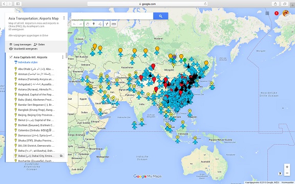
Asia China Mongolia Transportation - Airports & Railroads Satellite Map
This Satellite Image provides an overview of all International Airports in Asia, all Airports in China (PRC) and Mongolia. In addition all military airbases in China (PRC) listed.
Navigate map and click pins for additional information and video where available. Link through from any pin to location information and backgrounds.
Overview all transportation in the Peoples Republic of China and additional Asian Nations in one glance.
Direct Hotel & Resort booking + additional packages linked by location across China, Mongolia and neighboring Asian Nations.
If you have any information, photography or video to share on Hotan Airport or Hotan Military Airbase, please share with us in the China Travel Community on Facebook, see below window.
As may be gathered from publically available military intelligence on Hotan Airport, the military jet aircraft , specifically J-10 fighters (Chinese built and modified SU-27 (SK) Flankers), J-11 (B) Fighters and Q5 Fanfan air to ground attack aircraft are all stationed here in defense of the southern border, notably not primarily the Karakoram Pass to the west, but rather the still disputed Aksai Chin Region and other territories held by the Chinese Military inside Kashmir (part of Jammu and Kashmir region; heavily disputed between India and Pakistan but also eyed and partially claimed by China (P.R.C.). Since 2015 there have been increased rotations of fighter aircraft through this airfield.
Presumably, the drones are flown from Hotan in order to keep an eye on the age old mountain paths which over the past centuries and millenia provided silk road travelers with a direct albeit it extremely difficult to travel shorcut route passing from Hotan (Chinese Territory) southward via an area known as Aksai Chin into Kashmir and from there directly into Uttarakhand Province of India.
Although the mountain passes to the south of Hotan have officially been closed at least since the 1962 Sino-Indian border war in which the Chinese Captured the Aksai Chin region and advanced as far as the Indus (Musu) River, this does not mean that locals with sufficient knowledge do not still travel in between. That is, as with mountainous border area's separating major civilizations, of old - this trade and traveling route between Kashmir and Xinjiang has also been notorious for banditry and smuggling operations.
The airport and military airfield of Hotan is situated just to the south-west of Hotan Town proper where it is listed as situated at No.925 of the lovely sounding Welcome Road (迎宾路). Distance from the absolute town center to the airport is exactly 8.8 kilometers, with a travel time of some 5 minutes due to the lack of local traffic. Travel along Yingbin Road up to the center of town, or alternatively to your Hotel.
The Hotan Airport as a civil aviation airport is a simple facility of relatively minor importance as the only current flight connections are to Kashgar, Urumqi and Beijing-Capital Airport.
Resembling a classic Chinese military fighter base, Hotan Airport has one runway with a designated of (11/29) with a concrete surface. The runway and aprons and taxiways were upgraded in 2015. The current length of the runway is 3200 meters (10.499 ft). With a width of 50 meters, two jet fighters can take off side by side from this runway and it may also serve large cargo aircraft such as military transport ferrying heavy equipment, artillery and tanks into Hotan in case of war with neighboring India. The largest available civilian aircraft are able to land and take off from Hotan Airport.
Not counting the new Yarkand Airport and Military Airbase due west of Hotan in Kashgar City Prefecture the nearest airfields are in Indian and Pakistani
Google supported Map of Hetien (Khotan) in Hotan Prefecture of Xinjiang Uighur Autonomous Region (P.R.C.), by AsiaReport.com
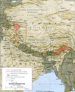
A geographic overview Map of Tibet, the Tibetan Plateaux and relevant adjoining regions and territories. Map includes a large part of Xinjiang Uyghur Autonomous Region (PRC), Kashmir, North-West Pakistan, Northern India, Nepal, Bhutan, Bangladesh and the culturally associated region of Myanmar (Burma). A small part of Yunnan Province of China is also depicted.
This Map clearly defines disputed borders and territories, Nations (except for Tibet), Provinces and Regions, as well as geographical features such as main mountain ranges, main rivers & lakes of the region, basins and plains, plus the locations and names of main cities, towns, monuments and landmarks.
Browse the Map and follow the Links where available to access more maps, information and photos on each location and landmark.
administered areas of Kashmir not Chinese Airports.
Nearest Aiport to Hotan is Leh Airport at Leh, Kashmir, India administered Kashmir, at distance of 385 kilometers. Also at a distance of some 385 kilometers lies the Fukche Advanced Landing ground, which is make-shift advanced landing ground situated just across the Indus River which currently represents the actual "line of control" (LAC) disputed border between China (P.R.C.) and India.
Second nearby listed airfield is the Pakistani controlled airfield and airbase at Skardu in the Gilgit-Baltistan region of the larger restive and disputed Jammu and Kashmir Regions at a distance of 432 kilometers. Kashgar International Airport is situated at 436 kilometers distance whereas the Aksu City Airport is situated at some 471 kilometers from Hotan Airport.
Currently, with 18 airfields operational in the Xinjiang Region (some seasonal only) the Hotan (County-Level City) Airport is the only airport in all of Hotan City Prefecture, however recently on June 17 of 2017 the Chinese Government announced that the green light had been given for the construction of an additional airport in Hotan City Prefecture, to be situated at the famous historic Silk Road Town of Keriya (Chinese: Yutian) in the far east of Hotan Prefecture. No intended date of completion has been given but according to the announcement, the new Yutian Airport is to be one of 10 new airports to be built in the restive Xinjiang-Uighur Autonomous Region by the year 2020.