The Yunnan Province Maps Index gives access to all Maps relevant to Yunnan Province and area's of Specific Interest within that Region, as used and/or produced by ChinaReport.com. Please use these Maps to find your way easily around the Region, Cities, Area's and many Monuments & Landmarks.
Geographic Maps on Kunming City and Area of Yunnan Province.
Kunming & Prefecture Maps
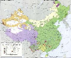
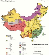
Map China Ethno-Linguistic / Language Distribution Tibet & China
A Full and complete Map of China (PRC) identifying all Language Areas big and small in all Provinces and Autonomous Regions of China.
Map includes Turkic Languages (Uygur, Kazakh, Kirghiz, Salar & Uzbek), Mongolian Language and Sub-Divisions (Mongol, Tu, Daur and Dongxian), Tungusic Peoples (Oroqen, Evenki and Xibe) and Languages, Korean, Tajik (Tadzhik), Mon-Khmer (Kawa + Puman (or Pulang)), Hui, Uygur (Uighur), Tibeto-Bhurman Languages, Tai and Miao, Yao and She' Language Area's and Borders. Main Area's and sub-divisions of Han Languages (Northern Mandarin, Eastern Mandarin, South-Western Mandarin and Cantonese) further included. This color-coded ethno-linguistic Map (of 1967 AD) identifies at a glance most ethnic minority regions in China.
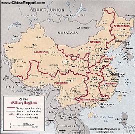
Originally thirteen military regions were established in the 1950's, but the number was reduced to eleven in the late 1960's. The resulting eleven military regions - Shenyang, Beijing, Lanzhou, Xinjiang, Jinan, Nanjing, Fuzhou, Guangzhou (including Hainan Island), Wuhan, Chengdu, and Kunming - were reduced to seven intheperiod 1985-88 AD. Currently,the active military districts include Lanzhou- including the former Urumqi MR, part of the Himalayan Mountains in North-West Tibet andAksaiChin, Chengdu Military Region including the former Kunming MR, Nanjing, which includes the former Fuzhou MR, Beijing, and Shenyang. Finally Guangzhou and Jinan Military Regions both appear to include parts of the former Wuhan MR.
The military regions arefurther divided into military districts, usually contiguous with provinces, and military sub-districts.
Yunnan - Kunming City & Prefecture Maps - All :
Geographic Maps on Lijiang City and Area of Yunnan Province.
Lijiang & Prefecture Maps
Yunnan Province - Lijiang City & Prefecture Maps - All :
Qinghai Province Map 1 - Geographic Map
A Geographic overview of Western China's Qinghai Province entire, delineating Provincial Borders and parts of neighboring Xinjiang-Uygur Autonomous Region, Gansu Province, Sichuan Province and Tibet (Xizhang) Autonomous Region. Includes Cities and Towns (shown by size), Main Monuments & landmarks, the flow of the yellow river in Qinghai Province, surrounding Bayan Har Mountain area's (TengGer),locations of Ethnic Minority Enclaves in Qinghai Province, Main Mountains (with Height), major highways, provincial railroads and main railroad-stations and main waterways & rivers. This Map further provides links to on site photos and information on Cities, Monuments and main transportation hubs of the wider Region.
Qinghai Province Map 2 - Schematic Map
A schematic overview of Western China's Qinghai Province entire, delineating Provincial Borders and parts of neighboring Xinjiang-Uygur Autonomous Region, Gansu Province, Sichuan Province and Tibet (Xizhang) Autonomous Region. Includes Cities and Towns (shown by size), Main Monuments & landmarks, the flow of the yellow river in Qinghai Province, surrounding Bayan Har Mountain area's (TengGer),locations of Ethnic Minority Enclaves in Qinghai Province, Main Mountains (with Height), major highways, provincial railroads and main railroad-stations and main waterways & rivers. This Map further provides links to on site photos and information on Cities, Monuments and main transportation hubs of the wider Region.
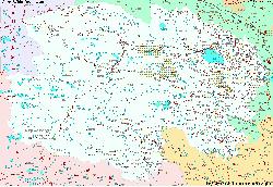
MapTibetHistoricalBorders
A Schematic Map of Historical Tibet, today Tibet Autonomous Region, Qinghai Province and a part of Sichuan province.
Included for reference are current Internationa Borders, provincial borders, locations and names of main cities and towns, main rivers and lakes, mountains,importantTibetan-BuddhistMonasteries and other places of significance.
Further Reports link to More Photos and History & Backgrounds of each City, Town or Ethnic Community of Yugur, Dongxiang Tibetan, Lhoba, Kazakh, Mongol or others where available.
Today Tibet only exists as Tibet Autonomous Region of China. Tourist visits require an additional visa !
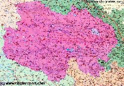
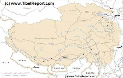
Tibet Autonomous Region Geographic Map 1A
This geographical Map gives a clear overview of Tibet Autonomous Region of China and immediate surroundings. including neighboring area's of Xinjiang-Uyghur Autonomous Region in the North-West, Qinghai Province in the East. Due to the South and South-West lies Sichuan Province and in the extreme South-West Yunnan Province. Surrounding Nations are many, small and large. These are Myanmar, Bhutan, Sikkim, Nepal, Bangladesh, India and Pakistan.
Map Includes Cities and Towns (shown by size), Main Monuments & landmarks of TibetAR, main mountains (with Height), major highways, provincial railroads and main railroad-stations and main waterways & rivers.
A SatelliteImage overview Map of the entireTibetanPlateauxincluding parts of bordering regions of Xinjiang-UyghurAR, Gansu Province, NingxiaHuiAR, Inner-MongoliaAR,Sichuan Province,andYunnan Province. Surrounding nations and Territories are: Myanmar (Burma), Bhutan, Sikkim, Nepal, Bangladesh, India, Kashmir and Pakistan.
This Map clearly defines Provinces and Regions, main mountain ranges, main rivers & lakes of the region, locations of main cities and landmarks.
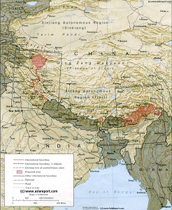
A geographic overview Map of Tibet, the Tibetan Plateaux and relevant adjoining regions and territories. Map includes a large part of Xinjiang Uyghur Autonomous Region (PRC), Kashmir, North-West Pakistan, Northern India, Nepal, Bhutan, Bangladeshand the culturally associated region of Myanmar (Burma). A small part of Yunnan Province of China is also depicted.
This Map clearly defines disputed borders and territories, Nations (except for Tibet), Provinces and Regions, as well as geographical features such as main mountain ranges, main rivers & lakes of the region, basins and plains, plus the locations and names of main cities, towns, monuments and landmarks.
Browse the Map and follow the Links where available to access more maps, information and photos on each location and landmark.
Demographic Maps relevant to Yunnan Prov.
Maps of Adjoining Regions & Territories
Yunnan Province Geographic Map 1A
A Schematic overview Map of YunnanProvince entire and large parts of neighboring Regions of TibetAutonomousRegion, SichuanProvince,ChongqingCityProvince, GuizhouProvince, aswellasthenationsofLaos and Myanmar(Burma).
This Map Includes Cities and Towns (shown by size), the location of ethnic minority communities of various size, Main Monuments & landmarks of YunnanProvince, major highways and roads, provincial railroads, a variety of border passes intoBurmaandLaos, main mountains with height plus main waterways, rivers and lakes of this large region. Please browse the map and follow the links to more information.
Sichuan Province Map Index Page. All overview Maps of Sichuan Province, Chengdu and other Cities in Sichuan, major landmarks and monuments, roads and highways, railroads and rivers, plus more.
Hebei Province Map Index Page. All overview Maps of Guizhou Province, Cities in Guizhou Province and their surrounding Area's, major landmarks and Monuments , Ethnic Communities and More.
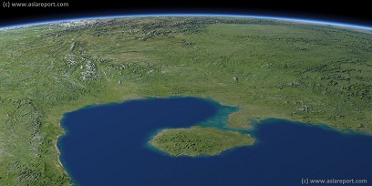
Asia Report - Map Image of South China, Gulf Tonkin, Hainan Island
This Satellite Image provides a clear overview of Hainan Island Province of China, The Gulf of Tonkin, large parts of Guangdong Province, Yunnan Province, Guanxi Zhuang Autonomous Region, Guizhou Province, Sichuan Province and Hunan Province of China; as well as parts of Northern Vietnam, Laos and Myanmar.
Marked on the map for orientatation are the names of major National and Provincial Capitals, cities, several towns and villages, oceans, sea's, lakes and rivers, as well as mountains, national borders, and locations of interest.
Browse the map and follow the links to more information, maps and photos of each location.
Asia Report - Maps - Distribution Islamic Faith Asia, Africa , Europe
A Demographic Map depicting the Distribution of the Islamic Faith in China and Asia, as well as Europe and the majority of the continent of Africa.
Sunni Islamic Areas are depicted in Green, whereas the Shia (Minority) Areas are depicted Darker Green.
The predominantly Muslim Xinjiang-Uygur Autonomous
China Report - Map China Ethno-Linguistic / Language Distribution China (P.R.C. & Taiwan R.O.C.) 02
A smaller rough schematic Map of China (PRC) identifying the Zones of in which the Main Groups of languages spoken throughout the Nation can be easily identified. The 4 main language groups; sino-tibetan languages, indo-european, austro-asiatic and altaic are further subdivided to region, province and Autonomous Regions as based on the 1964 Ethno-Linguistic Map.
Map further includes Turkic Languages (Uygur, Kazakh, Kirghiz, Salar & Uzbek), Mongolian Language and Sub-Divisions (Mongol, Tu, Daur and Dongxian), Tungusic Peoples (Oroqen, Evenki and Xibe) and Languages, Korean, Tajik (Tadzhik), Mon-Khmer (Kawa + Puman (or Pulang)), Hui, Uygur (Uighur), Tibeto-Bhurman Languages, Tai and Miao, Yao and She'
Region of China, Parts of Gansu Province and Small Ningxia Hui clearly stand out as the main muslim areas in China.
Language Area's and Borders. Main Area's and sub-divisions of Han Languages (Northern Mandarin, Eastern Mandarin, South-Western Mandarin and Cantonese) further included. This color-coded ethno-linguistic Map (of 1967 AD) identifies at a glance most ethnic minority regions in China.
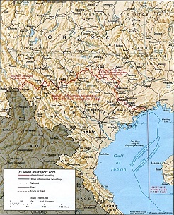
Vietnam border territories with China (P.R.C.) - Geographic Overview Map 1A
A geographic overview Map of the northern half of the Republic of Vietnam and southern provinces of the Peoples' Republic of China, with an emphasis on the delineated borders between the two.
Map includes a large part of Yunnan Province (PRC), Guangxi Zhuang Autonomous Region and Guizhou Province of China (P.R.C.). as well as parts of Laos and the Kingdom of Thailand.
This Map clearly defines disputed borders and territories, Nations, Provinces and Regions, as well as geographical features such as main cities, rivers & lakes of the region, basins and plains.
Browse the Map and follow the Links where available to access more maps, information and photos on each location and landmark.
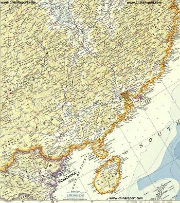
China Report - Historic Map - North Vietnam & South China in 1953
A large Geographic Map of parts of South China and North Vietnam in the year 1953 AD when the Peoples Republic of China was only 4 years old, the Korean war had recently ended in a stale-mate (which continues to this day) and at the same time the partition of Vietnam into Ho Chi Minh's Socialist Republic of North Vietnam and the American supported South Vietnam was just about to be formalized (1954 Geneva Convention) and taking shape.
Map includes parts of Guizhou Province , Yunnan Province, Sichuan Province, Hunan Province, Fujian Province, Guangxi Zhuang Autonomous Region, Guangdong Province and finally Hainan (Dao) Province of China (P.R.C.). In addition most of the northern "bulge", a total of 26 of the 50 Provinces of the Socialist Republic of Vietnam are depicted. The Provinces shown are Dien Bien, Lai Chou, Lao Cai, Ha Giang, Cao Bang, Son La, Yen Bai, Tuyen Quang, Bac Can, Thai Nguyen, Lang Son, Phu To, Boc Giong, Vinh Puc, the National Capital of Hanoi, Bac Ninh, Huai Duong, Hung Yen, Han Nam, Quang Ninh, Binh Hoa, Ha Tay, Ninh Binh, and the small coastal provinces of Nam Dinh, Thai Binh and Haiphong (City).
The Map makes use of old westernized spelling (Wayde Giles) and where possible current names of cities and towns.
Link through where available to find more information and additional details on each location and region as marked on the Map.
Military and related maps relating of Yunnan Province.
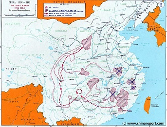
China Historic Map - Route Long March 1934/35 - 1A
A Schematic overview Map of the current Peoples Republic of China depicting the main route(s) of the epic Long March of 1934 and 1935.
Map clearly delineates PRC China current National borders and includes Provinces and Autonomous Regions, Main Cities and relevant Towns, initial Communist Soviets (Self-administered rebel areas), the routes followed by various elements among the Communist Groups and Armies, locations of important meetings points, main natural obstacles such as mountain ranges, the flow of large rivers such as the Yangtze River and Yellow River, position of the Great Wall of China in Gansu Province, Ningxia Hui Autonomous Region, North Shaanxi Province etc, rough estimated routes of main railroads of the time and other details of interest.
Mouse over locations and link through for additional information on each location.
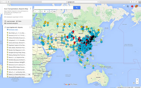
Asia China Mongolia Transportation - Airports & Railroads Satellite Map
This Satellite Image provides an overview of all International Airports in Asia, all Airports in China (PRC) and Mongolia. In addition all military airbases in China (PRC) listed.
Navigate map and click pins for additional information and video where available. Link through from any pin to location information and backgrounds.
Overview all transportation in the Peoples Republic of China and additional Asian Nations in one glance.
Direct Hotel & Resort booking + additional packages linked by location across China, Mongolia and neighboring Asian Nations.