This page was last updated on: June 16, 2008
54511
This geographical Map gives a clear overview of Hebei Province and immediate surroundings. including neighboring area's of adjacent provinces of Shanxi Province, Inner Mongolia Autonomous Region, Liaoning Province, Shandong and Henan Province. Provincial borders are delineated by various colors.
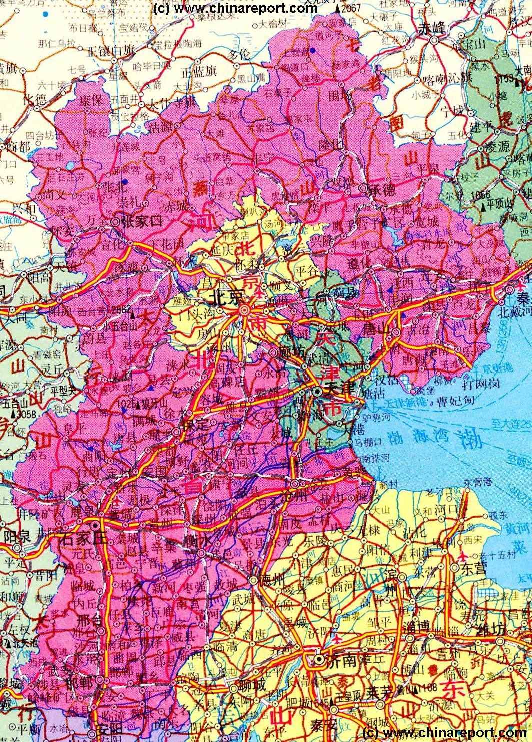
Focussing on Beijing and Tianjin Municipalities (City Province), the Map further provides locations of villages along main roads and railway lines, locations of Monumental and Cultural Historic Sites in the area (includes Great Wall of China locations) and locations of scenic or holy mountains in the region.
This Map is regularly updated with new reports on sites and links to
                                 more information, photos and backgrounds.
Introduction to Hebei Province of China Overview Map 2
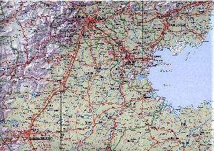
More Mpas of this Area
Dule Temple
Mutianyu Great Wall Site
Shanhai Pass Great Wall of China - "First Pass under Heaven"
Go to www.drben.net webring
ChinaReport.com at
To Main Menu of All Websites at DrBen.Net
The China Report
YanTong Shan (1109 meters)
Jieshi Shan (546 meters)
YanDu (Ruins of Ancient Capital)
Monastery-in-Mid-Air - Hunyuan Monastery (Xuan Gong)
Tianjin-JunliangCheng Airport
Imperial Fleeing the Heat Mountain Villa + 8 Outer Temples
Marco Polo Bridge
Ming Tombs Valley
Tiger Cave
Beijing City
Tianjin City
MiYun
Tanggu
Jin'an, Shandong Province
BaoDing
ShiJiaZhuang
TangShan
QinHuangDao
ChangPing Village
Datong, Shanxi
WeiFang, Shandong
ZiBo, Shandong
Handan
ChangLi
Luan Xian
FengRun
YuTian
Ji Xian
Dachang
Yangcun
LinliHe
East Terminus Great Wall of China - Old Dragons Head
Guanting Zhan
XuanHa
ZhangJiaKou (Kalgan)
HuaiRou
Simatai Great Wall Site
GubeiKou
Badaling Great Wall Site
Yanching
BeidaHe
Nankou
WanPing Village (Marco Polo Bridge)
TongXian
Pinggu
Shunji-Beijing "Capital" - International Airport
ZhangJiaKou Great Wall Pass
XiaDian
Chengzi
Chengde
XiaBanCheng
LuanHe
Pinquan
ZhunHua
Dao De Jing Column
LianggeZhuang
ZhuoZhuo
HunYuan
LangFang
Gu'An
Ba Xian
Dagu (Fortress)
BaoChang
Mu Ta Pagoda
YingXian
XiCheng
XuBu
YuXian
HanGu
Vairocana Monastery
LongQing Gorge
Xiao WuTaiShan (2870 Meters) + Monasteries
Marks location of Monument or Cultural Historic Site
Marks National or International Airport
Beijing "Capital" - International Airport
Beijing City
Marks City, Town or Village (Size)
WuLing Shan (1270 meters)
Xiao WuTaiShan (2870 Meters) + Monasteries
Marks Mountain and Height in Meters
Yunwu Shan (2520 meters)
Sjijiazhuang Airport
More Maps of this Area
Gu'An
ZhouZhou
Hebei Province - Map 1 Schematic.
Additional 10% OFF coupon
The Mysteries of the Imperial Palace in History DVD - Buy it Here !
Hidden Secrets and China's love & hate affair with the Forbidden City !
Buy it at Movie Universe - Click Here
Inner Mongolia AR
LIAONING
SHANDONG
Lonely Planet Shop
XiaBanCheng
ShanBanCheng
LongHua
ZhangSanying
PingQuan
DaQingHe
Leting
huangHua
CangZhou
Dezhou
HengShui
LingQing, Shandong Province
Anyang, Henan Province
YangQuan, Shanxi Province
LongGuanGuan
Wu Tai
Xia Wutai Shan Monasteries
Xiao Wutai Shan (3058 meters)
XiCheng
Sanggan River
Eastern Qing Dynasty Tombs
Zhunhua
ShaCheng
XinBao'An
WuLing Shan (1270 meters)
Yang River
Xiao Wutai Shan (2882 meters)
Jurna
River
GaoBeiDan
JiXian
Western Qing Dynasty Tombs
Peking Man Site
DaXing (Huangcun)
Pan Shan (xxx meters)
Chao
  River
XinZhou
  River
Luan River
Liu
  River
SHANXI
SHANXI
HENAN
Beijing Landmarks
Beijing Introduction
Beijing Online Sources
Beijing
Beijing Home
Beijing Hotels
Beijing Maps
Beijing Photo Galleries
Beijing Public Transport
Beijing by District(s)
Beijing Offline Sources
Beijing Air Fares
Beijing Car Rental
Beijing Cruises
Hebei Province
Hebei Province Home
Chengde Landmarks
Chengde Introduction
Chengde Online Sources
Chengde
Chengde Home
Chengde Hotels
Chengde Maps
Chengde Photo Galleries
Chengde Offline Sources
China Offline Sources
DrBen.Net Home
China Report Home
China Online Sources
China Online Store
China Maps
China
China Photo Galleries
China Report Club