Ethnic Minorities in Madoi & County
Learn More about the Ethnic Nationalities in Madoi
Madoi & County Today :
History of Madoi :
Madoi Climate & Weather :
Madoi Basic Knowledge :
To Qinghai Province Main Menu
This page was last updated on: July 12, 2017
The Madoi Report
Introduction to Madoi & County (རྨ་སྟོད་རྫོང ; 玛多县)
Madoi Landmarks & Monuments
Madoi & County Maps
Location : (....)
Elevation / Altitude:
Aveerage altitude of county: 3,970 metres (13,020 ft); Madoi: --- meters.
Surface Area:
Urban - No Information available.
County of Madoi - 25.000 Square Kilometers (?? sq miles)
Population of Madoi County: 10 thousand in the last census of 2010.
Go to www.drben.net webring
The China Report
The Madoi Report is part of the overall website www.ChinaReport.com & www.drben.net
Learn about what is new on this Site from below window.
To Main Menu of All Websites at DrBen.Net
ChinaReport.com at
Hi! from Doc Ben and Proud Staff
Alphabetically ordered list of Monuments, Landmarks and other sites of interest in and Around Madoi
A Full listing of Madoi and County Landmarks, Monuments, Hotspots and other sites of importance in alphabetical order. Search through the list to find your Full Report and Photo-Virtual Tour of each monument or landmark within the City, or Region of Madoi in Golog Tibetan Autonomous Prefecture, Qinghai Province of China (PRC).
Public Transport in Madoi
Main Railroad Station of Madoi - Photos and Introduction
No information is available on the Main and only Railway Station of Madoi.
Complete Listing of available Hotels in Madoi, Madoi County, Golog Tibetan Autonomous Prefecture, Qinghai Province, China (PRC).
Click to Go to Large Scale Map 1A
Madoi has a Railroad Station.
Throughout most of recorded history Madoi was a Town in the Golog Region of Amdo Province of Tibet. Although the Province of Qinghai was created on paper in 1928 AD, in practical terms it was only established during the 1950's under The Government of the Peoples Republic of China.

There is no specific history available for Madoi County.
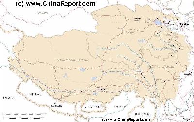
Read More in: 'History of Qinghai Province' (multiple pages).
Madoi is currently the administrative seat of Madoi County in the Golog Tibetan Autonomous Prefecture.
Find out the Details in the History of Madoi (Maduo).
Tweets by @ChinaReportcom1
Tibet - Tibetan Plateaux - Satellite Image Overview 1A
A Satellite Image overview Map of the entire Tibetan Plateaux including parts of bordering regions of Xinjiang-Uyghur AR, Gansu Province, Ningxia Hui AR, Inner-Mongolia AR, Sichuan Province, and Yunnan Province. Surrounding nations and Territories are: Myanmar (Burma), Bhutan, Sikkim, Nepal, Bangladesh, India, Kashmir and Pakistan.
This Map clearly defines Provinces and Regions, main mountain ranges, main rivers & lakes of the region, locations of main cities and landmarks.
Tibetan Plateaux Satellite Overview
Madoi County is a county of Golog Tibetan Autonomous Prefecture in Qinghai Province, China. It is known as the highest altitude county in the entire Peoples Republic of China.

The county is subdivided into the townships of; Huashixia Town (花石峡镇), Machali Town (玛查里镇) which also serves as the seat of the local Government, Zhalinghu Township (扎陵湖乡) and Huanghe Township (黄河乡).

The Huanghe Township consists of three minute villages which lie downstream from the Town of Madoi along the Yellow River near the point where the Re Qu and the Hei River join as tributaries.

Local Landmarks are:
In town - Madoi Cultural Center
26号 West Street, Madoi, Golog, Qinghai.

Gyaring Lake (Zaling), Ngoring Lake (Eling), the Oxen Head Stele (Niu Tou Monument)
at 92 kilometers from Madoi,
Bayankela Mountain, Maduo Ancient City, Golog or Goluo, Stele of the source of the
Yellow River, Stele of the source of the YueGunzongli River and the Yellow River Film
Expedition.

No public transport to Niu Tou monument or to Darlag Town or any other of the
townships of the County.
Darlag County has an alpine climate. No specifics available.
Please check: Qinghai Province - Climate & Weather in Qinghai Province.
Click to go to Full Version !!
Map Tibet Historical Borders
A Schematic Map of Historical Tibet, today Tibet Autonomous Region, Qinghai Province and a part of Sichuan province.
Included for reference are current International Borders, provincial borders, locations and names of main cities and towns, main rivers and lakes, mountains, important Tibetan-Buddhist Monasteries and other places of significance.
Further Reports link to More Photos and History & Backgrounds of each City, Town or Ethnic Community of Yugur, Dongxiang Tibetan, Lhoba, Kazakh, Mongol or others where available.
Today Tibet only exists as Tibet Autonomous Region of China. Tourist visits require an aditional visa !
Madoi is a County Town in Golog Tibetan Autonomous Prefecture (果洛藏族自治州). Thus, it has a large Population of Tibetan inhabitants.
To Qinghai Province - Index/Main Menu
All Maps relevant to Madoi, Golog Tibetan Autonomous Prefecture, Qinghai Province, China (PRC).
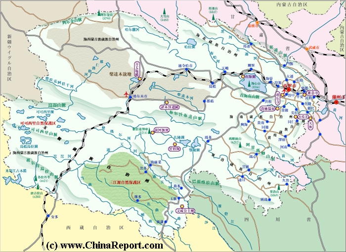
For all available Maps relevant to Madoi and Golog Tibetan Autonomous Prefecture (果洛藏族自治州) please refer to Qinghai Province Maps Index.
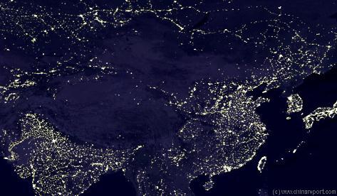
A Satellite Image of East-Asia at nightshowing clearly the very few lights in Qinghai Province and on the Tibetan Plateaux. Since the year 2000 AD, development has rapidly advanced but for various reasons Qinghai remains the poorest province in the Nation.
Source DVD
"Kekexili Mountain Patrol"
( no longer available )
The One and Only Documentary Film on this Region - Best Full Detail !!
Blabla ..
Click Map to go to Full Size Version !!
Golog
Jingyu
Lake
Kezi
Haltang
He
Toson
Hu
Burhan Budhan Shan
Maoen
Shan
Bayan Har
Mountains
Yellow River
Source
Altun Shan (Height 5798 Meters)
Minqin
Hei
River
Dang
River
Shule
River
Buh
River
Sur
Huaerdi
Qimantag
Narin
He
Boluntai
Behleg
Urt Moron
Shisuzhan
Xianride
Dagur
Qingba
Wudaoliang
Erdaogou
Tangulashan
Sewugou
Zhahe
Yaqu
Mongda
Serxu
Dabsan
Lake
Qarhan
Dong
Taijnar
Hu
Ho Xu
Lake
Xijir
Ulan Ul
Qumar
River
Heping
Xitieshan
Iqe
Dingzikou
Chalenkou
Yiliping
Huanggualiang
Laomangnai
Huatogou
Mangnai
Xorkol
Zhangye
Wuwei
Gaha
Nanqen
Yushu
Chindu
Zadoi
Zhidoi
Qumarleb
Jianca
Xunhua
Hualong
Tongren
Guanyuan
Haiyan
Guide
Linxia
Guinan
Gonghe
Zekog
Luqu
Jiuzhi
Baima
Darlaq
Gade
Tongde
Xinghai
Madoi
Tianjun
Delinghua
Ulan
Ganca
Menyuan
Qilian
Ngoring
Lake
Gyaring
Lake
Ulsan
Lakes
Golmud
Lake
Har
Qinghai
Lake
Xining
- Click Map to Enlarge to Full Detail Version -
Sichuan
Gansu
Golmud (Town)
Qilian Shan (Height 6654 Meters)
Soorj (IRussian federation)
Laomangnai
Ping'An
Ping'An, Ping'An County, Haidong Prefecture, Qinhai Province, China (P.R.C.).
Xinjiang AR
Tibet AR
Xining - Capital of Qinghai Province
Xitieshan
Iqe
Huanggualiang
Huatugo
Yiliping
Chalenkou
Dingzikou
Heping (Gansu Province)
16 Daoban
Xorkol (Xinjiang-Uygur AR)
Mangnai (Xinjiang-Uygur AR)
Ulan
Qilian
Tianjun
Xinghai
Guinan
Tongde
Zekog
Luqu
Jiuzhi
Baima
Gyümai (Jimai), also: Darlag, Darlag County, Golog Tibetan Autonomous Prefecture, Qinghai Province, China (P.R.C.).
Maqen
Madoi (Maduo), Madoi County, Golog Tibetan Autonomous Prefecture, Qinghai Province, China (P.R.C.).
Dulan
Dulan
Delinghua (or Delhi), Haixi Mongol Autonomous Prefecture, Qinghai Province, China (P.R.C.).
Maqen
Gade
Haiyan, Haiyan County, Haibe Tibetan Autonomous Prefecture, Qinghai Province, China (P.R.C.).
Guanyuan
Xunhua
Hualong
Minhe, Minhe County, Haidong Prefecture, Qinhai Province, China (P.R.C.).
Guide
Tongren (Rebkong), Tongren County, Huangnan Tibetan Autonomous Prefecture, Qinghai Province, China (P.R.C.).
Jainca
Lanzhou - Capital of Gansu Province
Chindu
Yushu or Gyegu, Yushu County, Yushu Tibetan Autonomous Prefecture, Qinghai Province, China P.R.C.).
Zadoi
Zhidoi
Qumarleb
Nanqen
Gaha (Gansu Province)
Wuwei (Gansu Province)
Zhangye, Zhangye Prefecture, Gansu Province, China (P.R.C.).
Shandan, Zhangye Prefecture, Gansu Province, China (P.R.C.).
Shandan
Togton
Lake
Tangulashan
Wudaoliang
Qingba
Ulan Ul
Lake
Yinma
Lake
Huiten
Nor
Shisuzhan
Erdaogou
Zhahe
Yaqu
Suojia
Sewugou
Xiwa
Serxu (Sichuan Province)
Mongda
Huaerdi
Sur
Tuolemuchang
Suojia
Qarhan
Dagur
Xiangride
Behleg
Boluntai
Urt Moron
Qimantag (Xinjiang-Uyghur AR)
Bianmagou
Bianmagou
Minqin, Wuwei Prefecture, Gansu Province, China (P.R.C.).
Jintie Shan (Height 5206 Meters)
Tangula Shan (Height 6205 Meters)
Jiangtse River
Source
Nyaindo Yuze (Height 5369 Meters)
Maqen Gangri Shan (Height 6282 Meters)
Bayan Har Shan (Height 5266 Meters)
Kezi
Peizhongzhan (Gansu Province)
Togton Gangri (Height 5689 Meters)
Buka Daban (Height 6860 Meters)
(Height 6316 Meters)
Yanzhi Shan (Height 3978 Meters)
Bayan Shan (Height 5030 Meters)
Ebo Shan (Height 4473 Meters)
Maonui Shan (Height 4472 Meters)
Dalongsai (Height 5496 Meters)
Gonghe
Menyuan
Linxia (Hui) Prefecture, Gansu Province, China (P.R.C.).
Ganca
No -
Find DrBen and ChinaReport on Facebook with the latest from www.drben.net.
DrBen Nijhoff | Maak je eigen badge
This page was last updated on: July 12, 2017
My Great Web page
Google supported Map of Madoi and County in Golog Tibetan Autonomous Prefecture of Qinghai Province (P.R.C.), by AsiaReport.com

AsiaReport.com - Mastermap of Asia (entire). weergeven op een grotere kaart
Tweets about "#Qinghai"
Qinghai Sources
Qinghai Province
Xining
Xining Home
Qinghai Home
Haixi Prefecture
Delingha + Haixi Home
AsiaReport.com Home
China Offline Sources
China Report Home
China Online Sources
China Online Store
China Maps
China
China Photo Galleries
China Report Club
Qinghai Economy
Qinghai History
Qinghai Maps
Qinghai Minorities
Qinghai Transport
Qinghai Monuments
Haibei Prefecture
Haibei + Haiyan Home
Haidong Prefecture
Haidong + Ping'An Home
Hainan Prefecture
Hainan & Gonghe Home
Huangnan Pref.
Huangnan + Tongren
Yushu Prefecture
Yushu + Yushu Home
Golog Prefecture
Golog + Maqen Home
Golmud
Golmud Home
Qinghai Geography
Yellow River in Qinghai