The Lhasa (ལྷ་ས་ or 拉萨) Maps Index gives acces to all Maps relevant to Lhasa, Capital City of Tibet, Tibet Autonomous Region of the Peoples Republic of China & Area's of Specific Interest within that Region as published at China Report. Please use these Maps to find your way easily around the City and many Monuments & Landmarks.
This page was last updated on: May 31, 2017
Lhasa Report
Lhasa (Tibetan: ལྷ་ས) Maps - Index
ChinaReport.comat
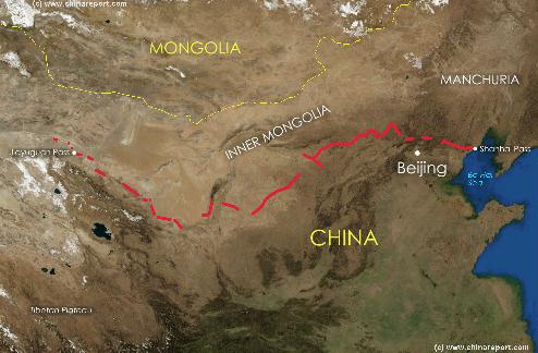
Great Wall of China Path & Locations Map
A Satellite image Based Map of China and East-Asia, with a super-imposed schematic Map of the Location and Path of the Great Wall as constructed during the Reign of the Ming Dynasty.
Included for reference are Locations and Names of Passes on the Great Wall of China and their significance. Further Reports link to More Photos and History & Backgrounds of each Great Wall of China Site. Further depicted are City names, geographical features of landscape, rivers and more.
Geographic Maps of the Silk Road Pathways, The Great Wall of China including in and near Tibet, the Military Commands of China, and the various historic maps relating to Tibet and Tibet AR.
Other Maps relevant to Tibet & History
Gansu Province Map 3 - Satellite Map
A Satellite Image based Map of Gansu Province entire and neighboring provinces clearly depicting the natural terrain features that shaped the Province of Gansu in History. Browse around the Image to the outlines of the Gobi & Tengger Deserts, view the Qinghai Plateaux extending from the West providing borders with Gansu Province and Sichuan Province. Central Gansu Province around the Capital of Lanzhou is formed by the Loess Plateaux and the flow valley of the Yellow River (Huang He). Otherwise distinct areas are the Throat of China, Hexi Corridor extending to the North-West and the Ningxia Yellow River Valley, a separate autonomous region and green patch in the North-East.
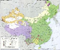
Map China Ethno-Linguistic / Language Distribution China
A Full and complete Map of China (PRC) identifying all Language Areas big and small in all Provinces and Autonomous Regions of China.
Map includes Turkic Languages (Uygur, Kazakh, Kirghiz, Salar & Uzbek), Mongolian Language and Sub-Divisions (Mongol, Tu, Daur and Dongxian), Tungusic Peoples (Oroqen, Evenki and Xibe) and Languages, Korean, Tajik (Tadzhik), Mon-Khmer (Kawa + Puman (or Pulang)), Hui, Uygur (Uighur), Tibeto-Bhurman Languages, Tai and Miao, Yao and She' Language Area's and Borders. Main Area's and sub-divisions of Han Languages (Northern Mandarin, Eastern Mandarin, South-Western Mandarin and Cantonese) further included. This color-coded ethno-linguistic Map (of 1967 AD) identifies at a glance most ethnic minority regions in China.
A Full Google Earth Supported Map of Tibet Autonomous Region by Google.com.
The China Report introduced on Levels of its Online Publishing's in April of 2009, including Tibet ARinApril2010.
Find Google Maps on nearly all Report & Photo Pages where appropriate and useful.
Adjacent Map gives direct access to Map Of Gansu Province by Google.
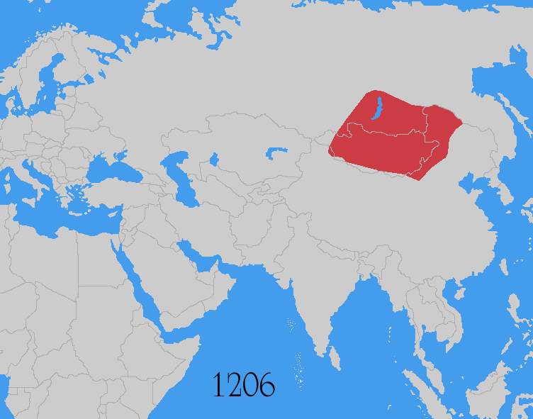
Map Yuan Dynasty Mongol Empire in Time 1206 AD - 1294 AD
A Schematic Map of the Mongol Empire of Genghis Khan (TeMuJin) and descendants through its several stages of conquest in its short but Impressive Existance in History. Timeline depicts the Mongol Conquest starting in the Year 1206 AD, when Genghis Khan first united the Mongol-Turkic Tribes of Mongolia and Lake BayKal becoming Great Khan. The Timeline continous through the year 1219 AD, the year 1223 AD taking Transoxiania, 1227 AD, 1237 AD when the Northern Jin Dynasty of China was annihilated, 1259 AD conquering ancient China above the Jiangste River and 1279 AD when all of China was taken and the Yuan Dynasty Eastablished under the Kublai Khan. Last is the Year 1294 AD when the Mongol Empire reached its largest geographical size and Zenith, 22% of world land area, but through lack of central leadership and over-expansion fragmented into 4 large parts, then imploded upon itself.
Asia Report - Map Trade Routes in Asia in the 13Th Century
A Schematic Map of the Eurasian Trade Routes existing in the 13Th Century. Clearly marked in Red Accent on the Map are the cities of the network of land-bound trading routes through Central Asia known as the Silk Road (the path of Marco Polo and others). Marked in Blue Accent are the Main Ports and Harbors of the Maritime Trade Routes that operated between the Arabian Peninsula and the Red Sea, the Indian Ocean and Coastal Cities, the Straights of Malacca, the South-China Sea's and beyond. As shown Maritime Trade to China mainly entered through Southern Harbors, then was distributed internally by use of the Grand Canal, the Yangste River and the Yellow River.
Map includes the Route travelled by Marco Polo, William of Rubruck and John of Pian de Carpine, the three famed European Travelers of the Time.
Locations of Main Trading Ports and Cities on Trade Routes of the Time are marked.
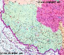
MapTibetHistoricalBorders
A Schematic Map of Historical Tibet, today Tibet Autonomous Region, Qinghai Province and a part of Sichuan province.
Included for reference are current Internationa Borders, provincial borders, locations and names of main cities and towns, main rivers and lakes, mountains,importantTibetan-BuddhistMonasteries and other places of significance.
Further Reports link to More Photos and History & Backgrounds of each City, Town or Ethnic Community of Yugur, Dongxiang Tibetan, Lhoba, Kazakh, Mongol or others where available.
Today Tibet only exists as Tibet Autonomous Region of China. Tourist visits require an aditional visa !
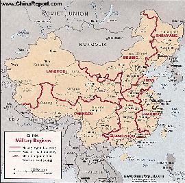
Map China 7 Military Districts (Regional Defense Commands)
Originally thirteen military regions were established in the 1950's, but the number was reduced to eleven in the late 1960's. The resulting eleven military regions - Shenyang, Beijing, Lanzhou, Xinjiang, Jinan, Nanjing, Fuzhou, Guangzhou (including Hainan Island), Wuhan, Chengdu, and Kunming - were reduced to seven intheperiod 1985-88 AD. Currently,the active military districts include Lanzhou- including the former Urumqi MR, part of the Himalayan Mountains in North-West Tibet andAksaiChin, Chengdu Military Region including the former Kunming MR, Nanjing, which includes the former Fuzhou MR, Beijing, and Shenyang. Finally Guangzhou and Jinan Military Regions both appear to include parts of the former Wuhan MR.
The military regions arefurther divided into military districts, usually contiguous with provinces, and military sub-districts.
Qinghai Province Map 1 - Geographic Map
A Geographic overview of Western China's Qinghai Province entire, delineating Provincial Borders and parts of neighboring Xinjiang-Uygur Autonomous Region, Gansu Province, Sichuan Province and Tibet (Xizhang) Autonomous Region. Includes Cities and Towns (shown by size), Main Monuments & landmarks, the flow of the yellow river in Qinghai Province, surrounding Bayan Har Mountain area's (TengGer),locations of Ethnic Minority Enclaves in Qinghai Province, Main Mountains (with Height), major highways, provincial railroads and main railroad-stations and main waterways & rivers. This Map further provides links to on site photos and information on Cities, Monuments and main transportation hubs of the wider Region.
Qinghai Province Map 2 - Schematic Map
A schematic overview of Western China's Qinghai Province entire, delineating Provincial Borders and parts of neighboring Xinjiang-Uygur Autonomous Region, Gansu Province, Sichuan Province and Tibet (Xizhang) Autonomous Region. Includes Cities and Towns (shown by size), Main Monuments & landmarks, the flow of the yellow river in Qinghai Province, surrounding Bayan Har Mountain area's (TengGer), locations of Ethnic Minority Enclaves in Qinghai Province, Main Mountains (with Height), major highways, provincial railroads and main railroad-stations and main waterways & rivers. This Map further provides links to on site photos and information on Cities, Monuments and main transportation hubs of the wider Region.
MapTibetHistoricalBorders
A Schematic Map of Historical Tibet, today Tibet Autonomous Region, Qinghai Province and a part of Sichuan province.
Included for reference are current International Borders, provincial borders, locations and names of main cities and towns, main rivers and lakes, mountains,importantTibetan-BuddhistMonasteries and other places of significance.
Further Reports link to More Photos and History & Backgrounds of each City, Town or Ethnic Community of Yugur, Dongxiang Tibetan, Lhoba, Kazakh, Mongol or others where available.
Today Tibet only exists as Tibet Autonomous Region of China. Tourist visits require an aditional visa !
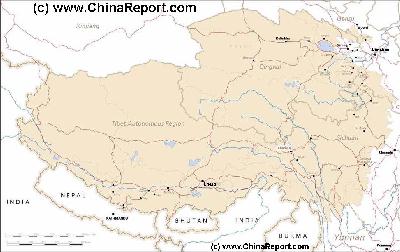
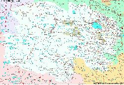
Tibet Autonomous Region Geographic Map 1A
This geographical Map gives a clear overview of Tibet Autonomous Region of China and immediate surroundings. including neighboring area's of Xinjiang-Uyghur Autonomous Region in the North-West, Qinghai Province in the East. Due to the South and South-West lies Sichuan Province and in the extreme South-West Yunnan Province. Surrounding Nations are many, small and large. These are Myanmar, Bhutan, Sikkim, Nepal, Bangladesh, India and Pakistan.
Map Includes Cities and Towns (shown by size), Main Monuments & landmarks of TibetAR, main mountains (with Height), major highways, provincial railroads and main railroad-stations and main waterways & rivers.
A SatelliteImage overview Map of the entireTibetanPlateauxincluding parts of bordering regions of Xinjiang-UyghurAR, Gansu Province, NingxiaHuiAR, Inner-MongoliaAR,Sichuan Province,andYunnan Province. Surrounding nations and Territories are: Myanmar (Burma), Bhutan, Sikkim, Nepal, Bangladesh, India, Kashmir and Pakistan.
This Map clearly defines Provinces and Regions, main mountain ranges, main rivers & lakes of the region, locations of main cities and landmarks.
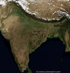
India, Pakistan, Nepal, Bhutan, Tibet AR- SatelliteImage
Overview Map 1A
A SatelliteImage based overview Map of India entire, including a large part of North-West Pakistan, Nepal, Bhutan, Bangladesh and Tibet Autonomous Region of China. Parts of Yunnan Province of China and Myanmar (Burma) are also visible.
This Map clearly defines Nations, Provinces and Regions, as well as geographical features such as main mountain ranges, famous mountain peaks with heights, main rivers & lakes of the region, basins and plains, plus the locations and names of main cities, towns, monuments and landmarks.
Browse the Map and follow the Links where available to access more maps, information and photos on each location and landmark.
Eurasia Map - Colonialism - Growth Colonies & Japan after 1801 AD
A Map drawing of the Eurasian continent , parts of North-East Africa and the Middle East in the 19Th Century between 1801 AD and 1900 AD. Focal points are the expansion of western colonial posessions of Portugal, Britain and France, as well as Russia moving from West to East. Labeled seperately is the later Rise of the Empire of Japan in the East.
Included in this Map are the main cities across the continent with their brief histories and events during the 19Th Century. Marked in Colors for clarity are the various colonial and imperialist Nations. As relating to China; special attention is payed to so called Treaty Ports. The First Treaty Ports were forced open by Britain in the year 1841 AD, but counted over 80 in total by the end of the 19Th Century. The most important Treaty Ports in China are marked and described with a short history where the map allows. Follow the links for more information on each location and subject.
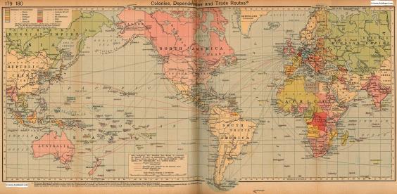
Colonialism - 1912 World Map Colonial Possessions & Trade Routes
A Map drawing of the World depicting the Colonial Possessions as they were distributed in 1912 AD. Superimposed and marked in colors are subsequent changes in Influences Spheres, colonies and possessions due to World War I ( 1914 AD - 1918 AD). Further included in this Map are the main cities across the continents with brief histories and events during the late 19Th Century and early 20Th century, where relevant. Marked in Colors for clarity are the various colonial and imperialist Nations. As relating to China; special attention is payed to so called Treaty Ports., the situation in Xinjiang, Tibet, Mongolia and Manchuria.
Soundbonus - 'Spring in Lhasa', By Oliver Shanti and Project.
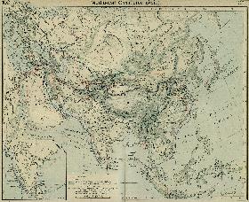
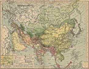
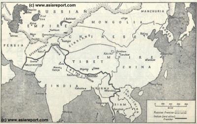
MapHistory - Schematic Asia - Russia China Britain Great Game 1900 AD
A Schematic Map of Historical East Asia at around the year 1900 AD and the turn into the 20Th Century.
Although the Manchu ruled Qing Dynasty Empire had previously conquered large parts of East Asia, including much of Korea, parts of current day Siberia, most of Mongolia, East Turkestan, Kyrgyz, Kazakhs and other tribal lands while subjecting Tibet to a subjugary role nominally ruled for its taxes but yet remote and inaccessible behind its mountainous walls, at the turn of the 20th Century the outer regions of the Qing Empire have been eroded away, much of the north and west increasingly under Russian control while in the south and along the coast Britons and others had fought their way into the Chinese Realm. Notably, Korea has been annexed by Japan and Tibet is shown as a de facto independent territory. Tibet will be invaded by Britain in 1901 AD and will declare Independence not long there after at the fall of
the Manchu Dynasty and the end of Manchu rule over China but also Mongolia and Manchuria in 1911 AD. Other groups such as Mongolians, Kazakhe and Kyrgyz will likewise attempt to reestablish their National independence after the fall of the Manchu Empire.
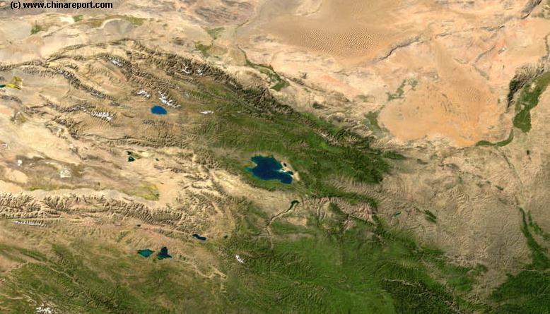
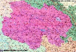
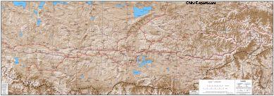
Tibet Report - Tibet - Relief Map of Central Tibetan Plateau
A detailed Relief Map of Tibet - The Central Tibetan Plateau.