Sites and Locations of special interest on the Satellite Image Map of Xinjiang-Uighur AR :
This page was last updated on: May 28, 2017
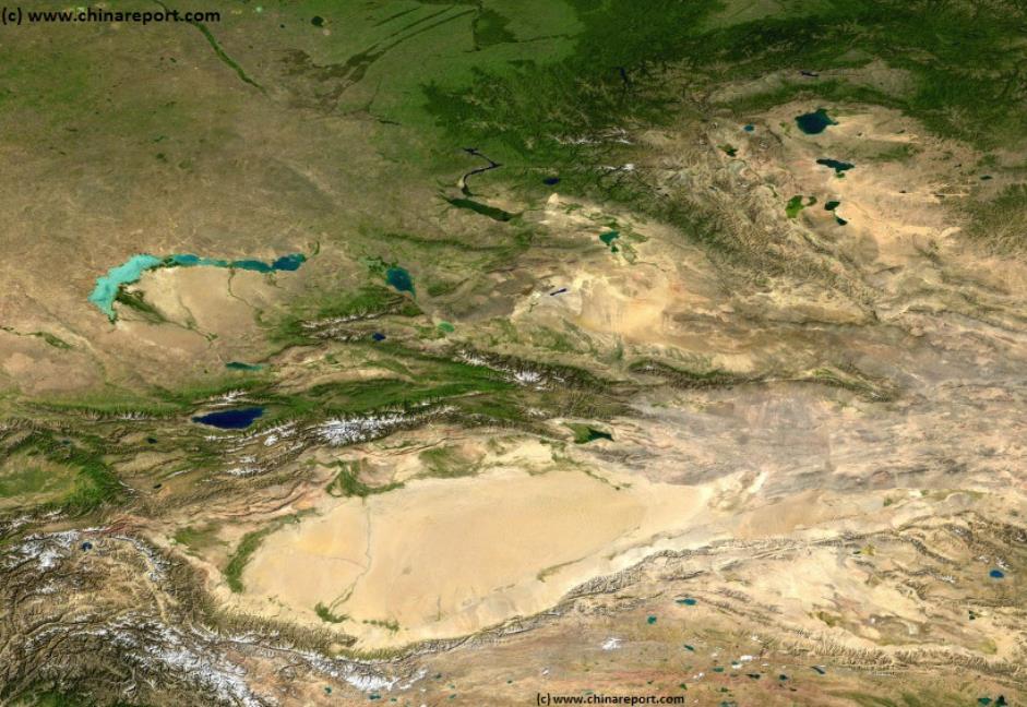
This Satellite Image Map gives a full overview of the Xinjiang-Uighur Autonomous Region of the Peoples Republic of China, as well as neighboring regions of the Republic of Kazakhstan, The Russian Federation, the Republic of Mongolia, the Chinese Provinces of Gansu and Qinghai Province, the Tibet Autonomous Region, the disputed territory of Aksay Chin (Indian, but Chinese controlled and made part of Xinjiang AR), the disputed territories of Jammu and Kashmir (disputed by India and Pakistan), a small part of the Wakhan Corridor in Eastern Afghanistan, the nation of Tajikistan and the Republic of Kyrgyzstan.
Study the map to properly understand the geographic connections between the Xinjiang-Uighur Autonomous Region and bordering nations. Surrounded by high mountain ranges to the North, the South and the West, communications with Central Asia traditionally revolve around a limited number of famous passes. To view the mountain passes in full, please refer to accompanying map.
Visible clearly, the geographic shape of the Xinjiang Region is determined by high mountain ranges and several deserts and basins. In the North the Altai Mountain Range forms the border with both Altai Krai and the Tuva Republic of the Russian Federation, as well as with the Republic of Mongolia situated to the North-East and East.
On the opposite side of this image, in the South, a natural border is provided by the northern rim of the large Tibetan Plateaux, the last edge of which is formed by the Kunlun Mountain and the Altyn Tagh Mountain Range. In the extreme west, surrounding the Taklamakan Desert, various mountain ranges flow together forming more natural mountainous borders with adjacent regions. In the North lie the heavenly mountains (Tian Shan) forming a natural border with Kyrgyzstan and parts of Kazakhstan. Due West of Kashgar, the Tian Shan meet the Pamir Mountains and Plateaux, whereas slightly more to the South the mountainous wall enclosing the Xinjiang-Uighur Region continues towards the Tibetan Plateaux in the form of the Karakoram Mountain Range, who's passes include the highest road passage through a mountain pass in the world. This road is known as the Karakoram Highway, and leads through the Karakoram Pass into neighboring Pakistan.
The other obvious geographic barriers forming the Xinjiang Region are its deserts. First of all, mostly out of image, in the East the Gobi Desert inhibits communications with the East and North-East. (to Mongolia and Inner-Mongolia AR). Furthermore, the Taklamakan Desert - clearly visible as a yellow ″disc″ in the south-west (lower left and central image) determines landscape, climate and most of life within the southern half of the Xinjiang Region. For millennia the sandy depths of the Taklamakan Desert have provided an impassable barrier for most of mankind, in history shaping the trajectory of the ″Silk Road″ and channeling it through a number of now famous and sometimes dried up Oasis.
A third notable feature is the Dzungar or Dzungarian Basin, which is clearly visible as a separate desert-like (yellow) entity due north of the centrally situated Capital of Urumqi. In the past this was a fertile valley fed by waters of the Irtysh and Ili Rivers. However, overtime the waters of this region have silted and partially dried up, leaving the Dzungarian Basin as a salty desert and steppe.
REGIONS AND LOCATIONS OF SPECIAL INTEREST WITHIN XINJIANG-UIGHUR AR ARE HIGHLIGHTED BELOW >>>
The China Report
Introduction to Satellite Map of Xinjiang-Uighur Autonomous Region of China (P.R.C.) - 1A
One of the least known special interest regions of the Peoples Republic of China lies in the north of Xinjiang Region and is known as the Eurasian Pole of Disconnection.
In geograhpic terms a pole of inaccessibility or ″disconnection″ is understood as a location (or region) that is the
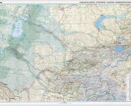
Asia Report - Map Roads & highways in Central Asian Nations
A geographical and topographical overview Map of the Central Asian Nations of (South) Kazakhstan, Tajikistan, Kyrgyzstan, Uzbekistan, Turkmenistan, and Parts of North Iran, North Afghanistan, North Pakistan, North India (Jammu & Kashmir), and the region of Kashgar (Kashi) in West China's Xinjiang-Uyghur Autonomous Region of China.
Map includes International Borders, national provinces and regions (where possible), main cities and roads, main lakes and waters, as well as the locations of Historic Sites, wildlife reserves, officially designated ethnic autonomous communities, main mountain peaks with heights and more coming soon !
Browse the Map, click and follow the links to additional information on each site and location. Click on selected highlighted Map sections for a more detailed map of that Region. Explore the connections in central asia as never before !
Full Google Map of 'unusual facility' (Part of Malan Base) in Lop Nor Bed of Xinjiang AR.
most challenging and difficult to reach owing to its remoteness from geographical features that could provide access. Although usually the term is usually used in reference to the North- and South poles of the Earth globe, geographers and explorers count several other such regions on the Planet. One of these is found in the extreme northern section of the Xinjiang Region as part of the Altai Mountains and is known as the Eurasian pole of disconnection. It is also known as the Continental Pole of Inaccessibility.
To be exact, in geographical terms this ″Continental Pole of Inaccessibility″ (46°17′N 86°40′E) is determined as the piece of land on the Eurasian continent that is situated farthest from any sea or ocean in geographical terms. This virtual point on Earth has been determined to be in north-western China, in the north of Xinjiang Region near the Kazakhstan border, and according to calculations lies some 2,645 km (1,644 mi) from the nearest coastline.
Although in principle a virtual point drawn on the map, in practice this point coincides with one of the remotest and roughest parts of the Xinjiang Region, a location that knows a very harsh climate and where road travel is most difficult during a large part of the winter season. Although the theoretical geographical point has been calculated as to lie roughly between the Cities of Karamay and Altai in North Xinjiang, in practice the EurAsian pole of disconnection is seen as the location where the bulk of the Altay Mountains blocks all access from North to South and East to West and Vice Versa, which is the region that lies immediatly north of the City of Altay. Only a few remote villages can be found in this region along the border with Altai Krai and the Tuva Republic of the Russian Federation. A large part of the local population consists of ethnic groups such as the Kazakhe, the Eluosi (Russian) and a few Mongolians. Rural locals survive through a semi-nomadic lifestyle, roads are sparse and communications with the rest of China are sparse.
LOP NOR SALT LAKE & NUCLEAR TESTING RANGE :
A second and more commonly known location or region of interest within the Xinjiang-Uighur Autonomous Region is the Lop Nor, formerly a large lake, currently a dried up and salty desert depression situated directly between the Taklamakan Desert and the even larger Gobi Desert to the East.
Historically the Lop Nor was known as a crucial stop over point on the so called ″Silk Road″, a network of trading routes that connected China with Central Asia, and Africa, Arabia and Europe beyond. Fed by China's 5th largest River, the Tarim, it was a refreshing and life giving lake rich in fish, bird and game that, together with the river formed the basis of what is known as the Northern Route of the Silk Road (within China).
Much later during the Mao Zedong Era, the Lop Nor was used for altogether very different purposes. At this time the former Lake Bed became the ideal testing ground for China's self-developed nuclear weapons (and their ballistic missile delivery systems). As a result, in 1964 AD Lop Nor became the nuclear testing site where China detonated its first nuclear weapon which was an atmospheric blast. Many more Chinese nuclear test followed until the unilateral compliance of China (P.R.C.) with the nuclear test ban treaty ratified in 1996 AD).
Although the Cold War, Mao Zedong's tyranny and the days of absolute secrecy are long over and some of the secret sites of National Security have even been opened as tourist attractions, much of the Lop Nor desert remains off limits and a number of unidentified military facilities remain. Together the most prominent of these are known internationally as the Malan Secret Nuclear
The Malan nuclear testing range is no longer a secret facility. However, at the time of its official opening in 1959 AD it was location of the highest possible secrecy. Among things base workers were not allowed to inform their relatives of their whereabouts, nor of their specific task. Communications were virtually non-existant, highly controlled by the scret service and police and all the scientific workers and support teams operated in absolute seclusion and under primitive circumstances to succeed in their given goals. The goal of the time was to achieve a Chinese nuclear bomb capability, as we know in hindsight, at virtually any price that needed to be payed.
In other words, the nation knew nothing of the Malan Base and it would not for a long time.
According to modern historic sources, the location of Malan was chosen for military purposes on the 21st November of 1958, upon the recommedation of Soviet advisers who had done joint surveys of several areas (their criteria for the choice remain undiscussed). Today it is known that between 1964 and 1996, China conducted 45 nuclear tests at the Malan facility and nearby at Lop Nor.
The headquarters of the huge nuclear test base is in Malan, about 125 km northwest of Qinggir, hence the name given to the facility. However the base is much larger and not tied to this one location at all.
Today, the Malan test-site, taken at its largest circumference including Lop Nor (test site), is the world's largest such Facility, occupying an area of over 100,000 sq km. According to various sources the Malan testing grounds include over 2,000 km of highways. Commercial satellite imagery (available online) shows that around 20,000 sq km have been used for various forms of nuclear testing. The current Malan Test Facility contains four testing zones situated within the Lop Nor Lake Bed depression. Three of these testing zones have been used for underground testing and one facility (the earliest one) was used for several atmospheric nuclear tests. The last atmospheric blast occured at Lop Nor on October the 16th of 1980.
Only two of the nuclear testing zones, together occupying an area of about 200 sq km, are currently seeing activity.
Apart from being the site of various historicly important events relating to China's nuclear history, today Malan is still operational as the main location for China's nuclear weapons training.
As rumoured but not confirmed, the Malan site (Red: grounds - territory) is also held to be a location of a nuclear weapons stockpile. Already in 1993 to 96 renowned research agencies such as "Jane's Intelligence Review" determined that Lop Nur is a likely site for interim high-level waste (HLW) storage and an eventual repository.
Rumor also has it that sections of this large base have been used as a nuclear dumping ground.
Full Google Map of 'unusual test facility' (Malan) in Lop Nor Region of Xinjiang AR.
Take to the Google Map and search for the various nuclear and military facilities ″hidden″ in the vastness of the Taklamakan and Lop Nor Desert. A good place to begin your map browse is to start at the so far unidentified facility situated near Ruoqiang Town (see adjacent Google Map). Other related military facilities lie in the wider regions surrounding Lop Nor and the giant Malan Nuclear Facility, most notably vital parts of China's ballistic missile and nuclear deterrence. The Bulk of China's nuclear deterrent force, including missile silo's and mobile launchers (Missile Artillery) have been positioned immediately to the South upon the Tibetan Plateaux (near Delingha and in Haixi Mongol Autonomous Prefecture), wheras the ballistic missile program and space flight program find their center at Jiuquan Space Launch Facility (formerly Dongfeng 1 military base) which is situated more to the East north of Jiuquan (Suzhou) within what is known as the Hexi Corridor (of Gansu Province).
For decades there have been reports livestock and people suffering from radiation sickness in the vicinity of Lop Nor and in Northern Tibet. Many trees in the lop nor region have lost their leaves and bark. Residents complain of losing their hair and suffering from skin diseases. There have been increases in rates leukemia, throat cancer, miscarriage, premature births and deformed babies. Inside the very large area of Malan, one of the nuclear testing grounds where nuclear devices were tested is situated less than 10 kilometers from a variety of rural type villages inhabited by ethnic Hui, Uighurs and Mongols. It is also rumored that nuclear waste has been dumped in the desert of Lop Nor, as well as in other locations in Xinjiang and neighboring Qinghai Province.
Read more about the Malan Base in: Landmarks & Monuments of Xinjiang-Uighur AR, Bayin Gholin Mongol Autonomous Prefecture ; ″Malan Nuclear Test Facilty″.
Read More about recently discovered and newly built facilities in Xinjiang inside and outside of the vast expanses of the Malan Base:
China Report - View o/t Tarim River Delta - Lop Nor dried lake area in Xinjiang AR