Need we Say More? Great DVD on the even Greater Wall of China.
Buy it at Movie Universe - Click Here
BaiMaGuan Great Wall
BaiMa Guan Great Wall location coordinates: 40°16′60″ North 117°20′60″ East
The BaiMaGuan Great Wall
In ...
Following their reports on crumbling watchtowers along the Baimaguan section
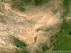
China Report - Map of the Gobi Desert & Yellow River Flow
A Satellite Image Map of the Entire Gobi Desert Region. Map overviews North-West Xinjiang Autonomous Region, Mongolia, Inner Mongolia and North and North-Eastern China giving a Full Overview of the Gobi Deserts. Clearly visible details of geographical features such as mountain ranges, rivers, valleys and lakes.
Map includes country borders, name and location details of Cities and Villages (clearly visible).
Mouse over Image to Reveal more information and follow the flow and path of the yellow river from Xining in Qinghai Province to the Bohai Sea. Details of old / former Yellow River flow (south of new) and new trajectory to the Bohai Sea.
Adjacent Map gives direct access to BaiMaGuan Wall Map by Google.
Learn more about the The Great Wall of China, Emperor Qin, his Terrecotta Armies and the horryfying fate of those who opposed him through this fascinating Film-Documentary.
Badaling
Juyong
Guan
Shixia
Guan
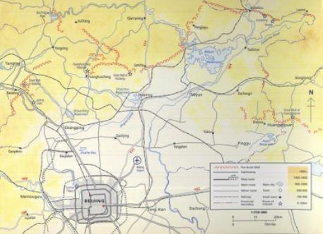
Map - Schematic - Beijing City Province Great Wall Locations
A Schematic Map overview of Great Wall locations and sections in Beijing City Province and Tianjin City Province. This Schematic Map depcits all seperate visitable Great Wall of China locations and sections within the 4 rural districts of Beijing; Pinngu, Miyun, Huairou and Yanqing County. Map further includes as the location of hiking paths, hotels, recreational facilties and historic monuments found in the vicinity of the path of the Great Wall. Find the locations of the Great Wall of China in Yi County in North Tianjin Province from where it continues past its many stations to end in the west at Shixiaguan in Yanqing County. Beyond the Great Wall continues into Zhangjiakou Prefecture of Hebei Province.
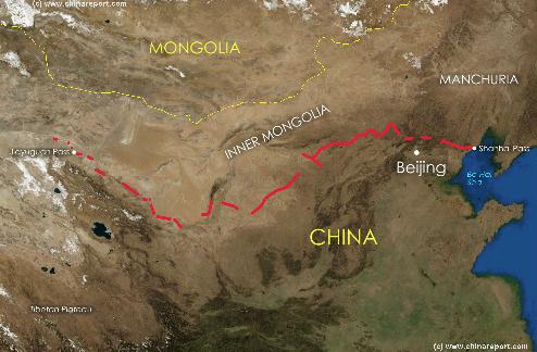
China Report - Map of the Great Wall during the Ming Dynasty
Satellite image of China and North-East Asia, with a super-imposed schematic Map of the location and Path of the Great Wall as constructed during the Reign of the Ming Dynasty. Included for reference are City names, geographical features of landscape, Names and locations of Passes on the Great Wall of China.