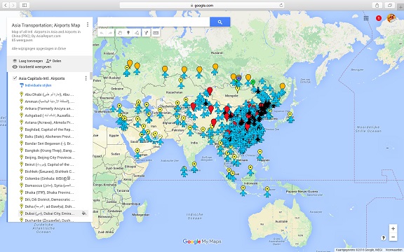
Asia China Mongolia Transportation - Airports & Railroads Satellite Map
This Satellite Image provides an overview of all International Airports in Asia, all Airports in China (PRC) and Mongolia. In addition all military airbases in China (PRC) listed.
Navigate map and click pins for additional information and video where available. Link through from any pin to location information and backgrounds.
Overview all transportation in the Peoples Republic of China and additional Asian Nations in one glance.
Direct Hotel & Resort booking + additional packages linked by location across China, Mongolia and neighboring Asian Nations.
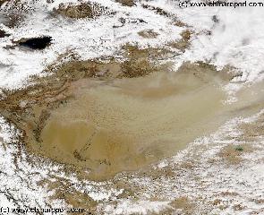
China Report - Map o/t Taklamakan Desert & Tarim River Basin 2a
A Second Satellite Image Map of the entire Taklamakan Desert and the Tarim River Basin in Xinjiang-Autonomous Region of Western China.
During the Time this Image was taken it was early spring; Mountains were snowcapped and a dust storm is blowing in the Central and Most Arid Regions of the Tarim River Basin.
Map gives explanation and backgrounds to Local Geography, the Flow of the Tarim River from the Pamir Mountains in the West to Lop Nur (Dry) in the East, ancient Oasis Cities of the Tarim Basin and Taklamakan Desert, the North and South Routes of the Silk Road in this Area, Past and Current Climate and Historic Backgrounds.
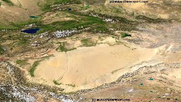
China Report - Map o/t Taklamakan Desert & Tarim River Basin 1A
A Satellite Image Map of the entire Taklamakan Desert and the Tarim River Basin in Xinjiang-Autonomous Region of Western China.
Map gives explanation and backgrounds to Local Geography, the Flow of the Tarim River from the Pamir Mountains in the West to Lop Nur (Dry) in the East, ancient Oasis Cities of the Tarim Basin and Taklamakan Desert, the North and South Routes of the Silk Road in this Area, Past and Current Climate and Historic Backgrounds.
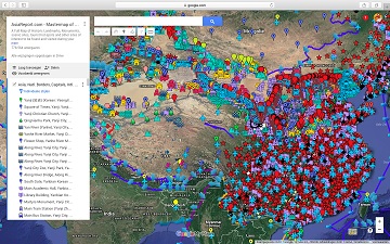
China Report - Satellite Master Map of China (P.R.C.)
A Satellite Google supported satellite image based Map of China (P.R.C.) and main cities in neighboring Nations. Map includes geographical details of all Chinese Borders and disputed borders with neighboring Nations, further main rivers, lakes, mountains and forests. In addition, National Capital, Provincial Capitals and all other Chinese Cities, location and information on all counties in China, as well as information and location of major public transportation hubs such as National and International Airports, Train Stations and railway lines, military airfields, landmarks, monuments, historic relic sites, tourist scenic locations and hot-spots and more.
Use Map to find location and navigation to information on all locations by clicking and linking through.
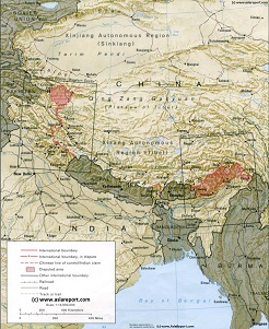
Asia Report - Map Image West Xinjiang AR & Central Asian neighbors
This Satellite Image provides a clear overview of West Xinjiang, Taklamakan Desert, North Pakistan, Afghanistan, Tajikistan, Kyrgyzstan, Kazakhstan and a large section of the (southern parts) Russian Federation.
Marked on the map for orientatation are the names of major National and Provincial Capitals, cities, several towns and villages, oceans, sea's, lakes and rivers, as well as mountains, national borders, and locations of interest.
Browse the map and follow the links to more information, maps and photos of each location.
Hotan Sat Image Maps
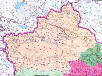
Xinjiang Autonomous Region Geographic Map 1A
A Geographic overview Map of the entire Xinjiang-Uygur Autonomous Region and large parts of neighboring Nations of India, Pakistan, Afghanistan, Tajikistan, Kyrgyzstan and Kazakhstan, The Republic of Mongolia, as well as bordering Chinese Provinces and Territories of Inner-Mongolia AR, Gansu Province, Qinghai Province and Tibet Autonomous Region. This Map Includes Cities and Towns (shown by size), Main Monuments & landmarks of Xinjiang AR, the Taklamakan Desert in South-Central Xinjiang AR, major highways, provincial railroads, a variety of border passes in the Karakoram Mountain Range and the Tian Shan Mt. Range, plus main mountains, waterways, rivers and lakes of this large region.
Xinjiang-Uygur Autonomous Region Shematic Map 2A
A Schematic overview Map of Xinjiang-Uygur Autonomous Region entire and large parts of neighboring Nations of India, Pakistan, Afghanistan, Tajikistan, Kyrgyzstan and Kazakhstan, Russia, The Republic of Mongolia, as well as Chinese Provinces and Territories of Inner-Mongolia AR, Gansu Province, Qinghai Province and Tibet Autonomous Region.
This Map Includes Cities and Towns (shown by size), Main Monuments & landmarks of Xinjiang AR, the Taklamakan Desert in South-Central Xinjiang AR, major highways, provincial railroads, a variety of border passes in the Karakoram Mountain Range and the Tian Shan Mt. Range, plus main waterways, rivers and lakes of this large region.
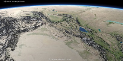
A geographic overview Map of Tibet, the Tibetan Plateaux and relevant adjoining regions and territories. Map includes a large part of Xinjiang Uyghur Autonomous Region (PRC), Kashmir, North-West Pakistan, Northern India, Nepal, Bhutan, Bangladeshand the culturally associated region of Myanmar (Burma). A small part of Yunnan Province of China is also depicted.
This Map clearly defines disputed borders and territories, Nations (except for Tibet), Provinces and Regions, as well as geographical features such as main mountain ranges, main rivers & lakes of the region, basins and plains, plus the locations and names of main cities, towns, monuments and landmarks.
Browse the Map and follow the Links where available to access more maps, information and photos on each location and landmark.
A SatelliteImage overview Map of the entireTibetanPlateauxincluding parts of bordering regions of Xinjiang-UyghurAR, Gansu Province, NingxiaHuiAR, Inner-MongoliaAR,Sichuan Province,andYunnan Province. Surrounding nations and Territories are: Myanmar (Burma), Bhutan, Sikkim, Nepal, Bangladesh, India, Kashmir and Pakistan.
This Map clearly defines Provinces and Regions, main mountain ranges, main rivers & lakes of the region, locations of main cities and landmarks.
Demographic & other Maps
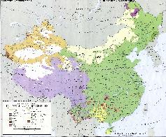
Map China Ethno-Linguistic / Language Distribution China
A Full and complete Map of China (PRC) identifying all Language Areas big and small in all Provinces and Autonomous Regions of China.
Map includes Turkic Languages (Uygur, Kazakh, Kirghiz, Salar & Uzbek), Mongolian Language and Sub-Divisions (Mongol, Tu, Daur and Dongxian), Tungusic Peoples (Oroqen, Evenki and Xibe) and Languages, Korean, Tajik (Tadzhik), Mon-Khmer (Kawa + Puman (or Pulang)), Hui, Uygur (Uighur), Tibeto-Bhurman Languages, Tai and Miao, Yao and She' Language Area's and Borders. Main Area's and sub-divisions of Han Languages (Northern Mandarin, Eastern Mandarin, South-Western Mandarin and Cantonese) further included. This color-coded ethno-linguistic Map (of 1967 AD) identifies at a glance most ethnic minority regions in China.
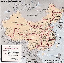
Map China 7 Military Districts (Regional Defense Commands)
Originally thirteen military regions were established in the 1950's, but the number was reduced to eleven in the late 1960's. The resulting eleven military regions - Shenyang, Beijing, Lanzhou, Xinjiang, Jinan, Nanjing, Fuzhou, Guangzhou (including Hainan Island), Wuhan, Chengdu, and Kunming - were reduced to seven intheperiod 1985-88 AD. Currently,the active military districts include Lanzhou- including the former Urumqi MR, part of the Himalayan Mountains in North-West Tibet andAksaiChin, Chengdu Military Region including the former Kunming MR, Nanjing, which includes the former Fuzhou MR, Beijing, and Shenyang. Finally Guangzhou and Jinan Military Regions both appear to include parts of the former Wuhan MR.
The military regions arefurther divided into military districts, usually contiguous with provinces, and military sub-districts.
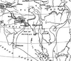
This Schematic Map shows the entire route of the first ever recorded Journey between China and India as made by the Chinese Monk Faxian in the years 399 AD to 412 AD.
The Path of the Journey is less clear than with the later Monk Xuanzang but led though Lanzhou, Dunhuang and Turpan, as well as Khotan and further led through various Central Asian territories today part of Kyrgyzstan, Afghanistan, Pakistan and India. The Return Journey was made by ship and led from the Bengal Coast via Ceylon (Sri Lanka) and parts of current day Indonesia back to the Chinese Coast. Faxian is known to have arrived back in the year 412 AD. His recordings and adventures becoming famous in all of China where they remain legendary to this day.
Map - Travel Route of Faxian (399 AD - 412 AD)
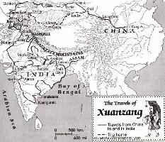
This Schematic Map shows the entire "Journey to the West" as made by the Chinese Monk Xuanzang in the years 629 AD to 645 AD.
The Path of the Journey to India led though China, Kyrgyzstan, Tajikistan, Afghanistan, Pakistan and India. The Return Journey led through Pakistan and Afghanistan to reach Kashgar in current day Xinjiang-Uyghur Autonomous Region of China. Because the (Han) Chinese Cultural Zone during the Tang Dynasty Era only reached as far as Dunhuang, where the Great Wall began, Xuanzang had to travel south-east from Kashgar via Yarkant and Hotien (Khotan) along the South Route around the Taklamakan Desert to finally return to his native China in 645 AD.
Map - Travel Route of Xuanzang - Journey to the West