Introduction to Xinjiang (شىنجاڭ) Uyghur Autonomous Region of China
ChinaReport.comat
Xinjiang Uyghur Autonomous Region
1980 AD, construction
of the two top-secret US lectronic signal (SIGINT) monitoring sites in Xinjiang, one at Qitai and the other Korla
These listening posts were manned by Chinese Nationals trained by the US Government to monitoring Soviet missile tests and other communications, electronic signals that the americans were unable to aquire after the Iranian revolutionaries closed down
Tracksman 1 and 2 in Iran.
The Top-Secret listening Stations in Qitai and Korla apparently continued their electronic spying operations until the end of the Soviet occupation of Afghanistan in 1989 AD.
Construction and opening of the Karakoram Road or Highway, leading directly from Kasghar in Xinjiang to the Capital of Pakistan at Islamabad, traversing some of the highest mountain passes in the world.
In the 1950's, Xinjiang Uygur became the scene of large scale and secretive military works. Apart from the task of guarding the border and strenghtening infra-structure for the Peoples Liberation Army, the main purpose of the military activities in these far western region was the building and developing of a (almost) home-grown Chinese Nuclear program.
During the later stages of this development, the remote strecthes of the Taklamakan Desert on the border between Gansu, Inner-Mongolia Autonomous Region and Xinjiang Autonomous Region were chosen as the best location for nuclear testing and related secretive military activity.
The first Chinese nuclear-weapons test site was located at Lop Nor, where in the 1960's China's first crude nuclear device was exploded.
Lop Nor is situated near the entrance to the historic Hexi corridor running down from the High North near Lop Nur and Dunhuang, wedging between two mountain ridges and bending around the Heights of the Qinghai Plateaux to descend down and end at Lanzhou.
This section is dry and arid and often windy, and consist of barren graveled lands and salt lakes. Rivers, formed by melting waters from nearby mountains cut across the plain, but waters rapidly flow downstream to end up in the Yellow River (Huang He) near Lanzhou.
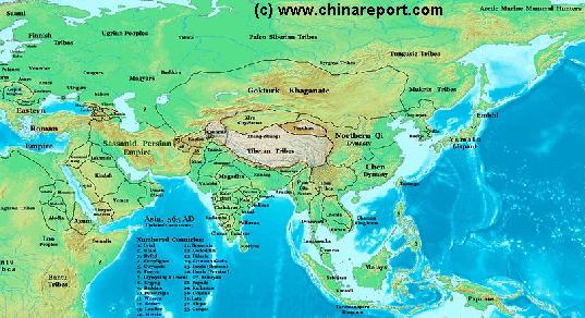
China Report - Map of Ancient Asian Empires and Tribes in Asia 565 AD
An overview Map of Asia Entire clearly demarkating the Territories, Nations and Tribal Area's of the Continent in the year 565 AD. Japan is split between the Yamato Kingdom and Emishi. In Korea three Kingdoms Rule among which the largest Goguryeo. China is split in a Northern Dynasty of the Qi, and a Southern Dynasty of the Chen. While in the Far west the Qi Empire stretches as far West as Dunhuang, the Silk Road is temporarily blocked by the unification of Mongol Tribes in the Gokturk Khanate and the appearance of the small XiYe City State in the Tarim River Basin.
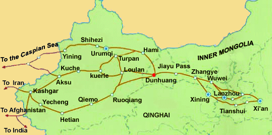
Schematic Map of the many sub-pathways of the Silk Road in China clearly showing the one-unavoidable pathway of the Hexi Corridor.
Qilian Mt Range
Mazhong
Mt Range
Taklamakan Desert
Qinghai Plateux
Gobi Desert
Gobi Desert
Tibetan Plateux
Tian Shan
Mt Range
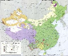
A Full and complete Map of China (PRC) identifying all Language Areas big and small in all Provinces and Autonomous Regions of China.
Map includes Turkic Languages (Uygur, Kazakh, Kirghiz, Salar & Uzbek), Mongolian Language and Sub-Divisions (Mongol, Tu, Daur and Dongxian), Tungusic Peoples (Oroqen, Evenki and Xibe) and Languages, Korean, Tajik (Tadzhik), Mon-Khmer (Kawa + Puman (or Pulang)), Hui, Uygur (Uighur), Tibeto-Bhurman Languages, Tai and Miao, Yao and She' Language Area's and Borders. Main Area's and sub-divisions of Han Languages (Northern Mandarin, Eastern Mandarin, South-Western Mandarin and Cantonese) further included. This color-coded ethno-linguistic Map (of 1967 AD) identifies at a glance most ethnic minority regions in China
Map China Ethno-Linguistic / Language Distribution China
Find DrBen and ChinaReport on Facebook with the latest from www.drben.net.
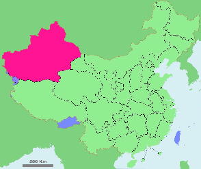
Schematic Map showing the location of Xinjiang Uyghur Autonomous Region within the Peoples Republic of China.
History of Xin Jiang, the Western Territory :
The Chinese history of the Regions that today make up Xinjiang begins as early as the Han Dynasty (206 BC - 220 AD), however as described on our Chapter on the Silk Road, the history of the trading paths from the west and Central Asia into China goes back considerably further, to the invention of the wheel and the animal-drawn cart which for the first time enabled or at least greatly facilitated long distance travels.
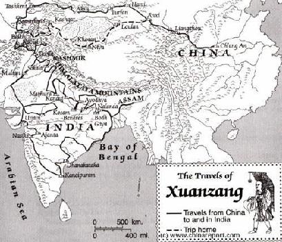
Later, during the Tang Dynasty era, a Chinese Monk named Xuanzang traveled along the silk road pathways to find his way into India. Bringing back invaluable knowledge and a huge library of scriptures, he became famous in history as a teacher and Professor of Buddhism in the then Capital of China, Chang' An.
In the 13Th Century the renowned European traveler and explorer Marco Polo traveled through the City of Kashgar and the Xinjiang Region on his way into the Han Chinese Nation and the Mongol Khanate of Cathay.
In the 17Th Century a lesser known European traveler named Bentos De Goes made roughly the same harrowing journey.
At the end of the 19Th Century and in the beginning of the 20Th Century, the region of Xinjiang would become part of what today is often refered to as the 'Great Game' for Central Asia. During this period a variety of international explorers tried to reach the remote far western region, mapping, digging and recording as they went. Apart from several Russian explorers, the West was best reconnoitered by Sven Hedin and (Sir). Marcus Aurel Stein who left large volumes of historicly valuable information.
In the beginning of the 6Th Century AD, during the rise of a new centrally organized Dynasty in China, the Tang Dynasty, much of the territory of what is today the Illi kazakh Region of (North) Xinjiang fell under control of wild barbarian tribes, which previously has organized into the so called Gokturk Khanate, an alliance of Central Asian and Mongolian Tribes.
The Silk Road pathways leading from China into Central Asia were further explored and invaed by the Han Chinese during the turbulent rise of the Tang Dynasty (608 AD - 907 AD), its armies eventually reaching Buchara and Samarkand, and setting up camp along the Southern Shores of the Caspian Sea.
On the renewed econmic succes of the Silk Road and unprecedented International Trade of Chinese goods, the Tang Dynasty saw a highpoint of Chinese military, economic and cultural power, extending Chinese influence far into Central Asia and onto the Tibetan Plateaux. In this period, the Western Region of Xinjiang for the first time was solidified into
the Chinese Empire. Although still inhabited by 'foreign and exotic tribes' and the territory of bandits, robbers and murderous rebel uprisings, Tang Dynasty armies set up military bases in the region on a large scale, setting up fortress farms where immigrants sent from afar could farm their lands and develop the economy, while doing wartime duty in times of tension. During the highpoint of this Era, the Great Wall of China extended beyond today's Great Wall of the Ming Dynasty (1368 AD - 1644 AD) Era, reaching well beyond Jiayuguan in neighboring Gansu Province and the current end of the Great Wall of China to reach Dunhuang (Gansu), and from there extend into the Xinjiang Region all the way to the then large expanse of the Lop Nor, not only a lake but a region of extensive marshes deadly to any army. As it is commonly understood today, a long string of Fire-Beacon Towers extended the protection offered by the Great Wall even further along the economic artery of the Silk Road.