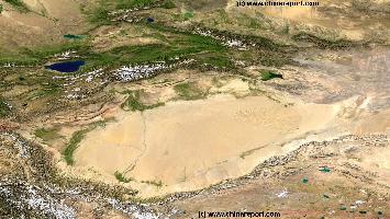
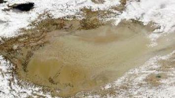
Lop Nor or Lop Nur (Uyghur: لوپنۇر; Chinese: 罗布泊), used to be one of the large fresh water lakes along the silk road, situated at particularly important and strategic location, wedged between the sand dunes of the deadly Taklamakan Desert and the equally deadly and sandy extends of the Western Gobi Desert. Today it is officially counted as a group of small, now seasonal salt lake sand marshes between the Taklamakan and Kuruktag deserts in the Bayingolin Mongol Autonomous Prefecture, southeastern portion of Xinjiang Uygur Autonomous Region in the People's Republic of China.
Due to climatic changes arising over the last 1000/800 years, as well as human influences as use of water for agricultural purposes, the Lop Nor lake and its feeding artery the Tarim River have dried up. The earliest recording of this event occuring was in the late 19Th Century, whereas after the year 1910 AD the lake is considered as a Salt Lake, seasonally and progressivily dried up. Famous from document detailing travels along the Silk Road, including Marco Polo's, the lush Lop Nor sadly is no more. Today its regions are sparsely, if ever visited, only a few rods traversing north and south around the empty basin. Along the rim of the former lake various historic now ruinous sites can be found. Among them, the ruins of the Lost City and Kingdom of Loulan. The other is the site of the lost City of Miran on the south-west edge of the basin.
The Lop Nor lake is truly legendary in world history as the site of archeological finds and explorations done by famous explorers such as German Ferdinand von Richthofen, Russian Nikolai Przhevalsky, Swedish Sven Hedin and the Austrian turned Englishmen, (later Sir) Marcus Aurel Stein, who all made extensive travels to reach the area, map it and explore the archeological remains left in the barren regions of the Taklamakan and Gobi deserts. Famously, the lake was re-discovered by Sven Hedin, who - at the end of his strength and water- passed out to die, only to be signalled of nearby water of the alarm calls of a bird. Subsequently, that day in 1900 AD, the then refilled lake saved the explorer and not much later became infamous as a life-giving Oasis in otherwise terribly inhospitable regions.
As Marco Polo had reported of his journeys West of the Lake, heading towards Dunhuang in Gansu Province, in ancient times the roadway through the desert - about 9 or 10 days walking for a Camel- was littered with corpses of dead animals, as well as their owners, left there for eternity for no one would venture out to come and find them. If it was bad in the old times, the climate at Lop Nor has not improved. As late as on June 13, 1996, the Chinese explorer Yu Chunshun died while attempting the first ever walk across Lop Nur.
In the 1950's and 1960's the Lop Nor Area was a far away and remote expanse, which was found perfect for secret military activities and the founding of the Chinese home-grown nuclear program. Eversince, bases for the Chinese Nuclear Defense Forces and Missile Development have been located along the Hexi Corridor in adjacent Gansu Province, the Lop Nor and other area's of Xinjiang, and the north rim of the Tibetan Plateaux (Qinghai Province).
After lenghty preparations and hard work at many universities, bais, technical instutes and army branches, China was finally ready to effect its very first nuclear bomb test in 1964 AD. Codenamed "596" and under the watchful eye of Russian Bases as well as American built U-2 spy planes (flown from India), the first device was tested in a surface explosion with its ground zero at Lop Nur. The succesful test, which had beforehand been a complete secret to the Chinese Public, was henceforth revealed to the public leading to aplause and a boost in moral throughout the nation.
Eversince 1964, the lake has been used as a nuclear test site until in 1996 China fully ratified the nuclear test ban treaty ending all testing in the area. In total 45 nuclear tests were conducted at Lop Nor.
According to various sources, the headquarters of the test base is at Malan, about 125 km (78 mi) northwest of Qinggir. It is known as the Malan Nuclear Testing Facility.
Lop Nor Lake
The Bosten Lake
The Manas or Manaus Lake
Main Rivers and Waterways of Xinjiang-Uyghur Autonomous Region :
Although the central region of Xinjiang is made up by the Taklamakan Desert and among the dryest and most dangerous desert regions in the world, the Xinjiang Autonomous Region counts many rivers and springs which throughout the last two millenia have sustained life in these remote and rugged regions.
Springing from the mountain gletsjers atop the surrounding high mountains.
The main river in Xinjiang is the Tarim River, which runs through the tarim basin and along the Taklamakan Desert in the south of Xinjiang Region. The Tarim is China's westernmost river and ranks as the fifth longest river in China. Fed by melting water from a variety of rivers along its route, the Tarim river flows roughly from Kashgar in the West, along the north rim of the Taklamakan Desert, eastward to end up near the Lop Nor wandering salt lake and the silk road town of Dunhuang, near the Western border of Gansu Province.
Historically speaking, the Tarim river was a lifeline of water providing a viable road to the East in these outright barren regions, providing a backbone for the Silk Road along its most dangerous and lethal section. Around the year 1900 AD, when it was rediscovered by the Norwegian explorer Sven Hedin, the lake still held water. However, as recorded, the lake later dried out and today much of the Tarim river suffers a similar fate throughout much of the year. Local Governments and authorities are trying to deal with this problem, with little success.
Among the famous historic cities and sites along the Tarim River are the city of Kashgar (upstream section), the towns of Tarim, Hadadun and the ruins of the ancient lost town of Miran are located in the outflow section of the Tarim River, the once large and bountyful Lop Nor, now a salt lake. Along the length of the river many Silk Road relics are found and there are various sites with fairly unknown and unvisited Buddhist Caves.
Other rivers in the South of Xinjiang AR are the Yarkent River, the Kashi (Kashgar) River and the Aksu River in the far West, the Hotan, Keriya and Niya and Cherchen Rivers flowing from the Kunlun Mountains and the Tibetan Plateux into the south rim of the Taklamakan Desert in the
Introduction to Xinjiang (شىنجاڭ) Uyghur Autonomous Region of China
ChinaReport.comat
Xinjiang Uyghur Autonomous Region
China Report - Map o/t Taklamakan Desert & Tarim River Basin
A Satellite Image Map of the entire Taklamakan Desert and the Tarim River Basin in Xinjiang-Autonomous Region of Western China.
Map gives explanation and backgrounds to Local Geography, the Flow of the Tarim River from the Pamir Mountains in the West to Lop Nur (Dry) in the East, ancient Oasis Cities of the Tarim Basin and Taklamakan Desert, the North and South Routes of the Silk Road in this Area, Past and Current Climate and Historic Backgrounds.
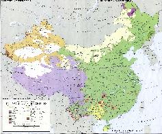
A Full and complete Map of China (PRC) identifying all Language Areas big and small in all Provinces and Autonomous Regions of China.
Map includes Turkic Languages (Uygur, Kazakh, Kirghiz, Salar & Uzbek), Mongolian Language and Sub-Divisions (Mongol, Tu, Daur and Dongxian), Tungusic Peoples (Oroqen, Evenki and Xibe) and Languages, Korean, Tajik (Tadzhik), Mon-Khmer (Kawa + Puman (or Pulang)), Hui, Uygur (Uighur), Tibeto-Bhurman Languages, Tai and Miao, Yao and She' Language Area's and Borders. Main Area's and sub-divisions of Han Languages (Northern Mandarin, Eastern Mandarin, South-Western Mandarin and Cantonese) further included. This color-coded ethno-linguistic Map (of 1967 AD) identifies at a glance most ethnic minority regions in China
Map China Ethno-Linguistic / Language Distribution China
Find DrBen and ChinaReport on Facebook with the latest from www.drben.net.
The Xinjiang Region is home to several of China's famous and scenic lakes, as popular legend would have it surrounded by the likes of the happy and exotic tribes of the Kyrgyz, Uzbek, Tajiks, Kazakhe, and Eluosi, the latter descendants of Russian migrants into the Region. These famous lakes are Bosten Lake, Manas Lake and less famously because of its extreme remoteness, the Ulungur Lake.
South. All of these, except for the Niya and Cherchen rivers ultimately end up as tributaries to the Tarim River, all historically flow out into the now usually dried up Lop Nor (Salt Lake), in history a mythical wandering lake only refound and known to the outside world since the last decade of the 19th Century.
Rivers in North Xinjiang Region are slightly less easily described and understood.
The Ulungur River is the most important river in the Altai Regions in the extreme North of today's Xinjiang Uyghur Autonomous Region. Also known in Mongolian as the Urungu River, this flow of water originates in the Republic of Mongolia where it is known as Bulgan River. The upper flow of the Bulgan River is a rugged mountainous area which is home to the rare Mongolian Beaver. From this source area the flows from the Mongolian Altai Mountains into Xinjiang where it flows through the and the Bulgan Beaver Nature Rserve, which is situated on the Chinese side in Qinggil County, the northernmost county in all of Xinjiang Yughur Autonomous Region and an area known for its frosty winter climate and abundant snowfalls. Eventually, coming down from the Altai Mountains into the wider Dzungar plain of Xinjiang, the Ulungur river flows in the Ulungur Lake, which is situated in the Fuhai County of Altay Prefecture. Ulungur Lake, the largest and thus most important body of water in the north. The River itself is about 700 kilometers long whereas the Lake, now dwindling after mis-management of its waters, has split into two seperate parts. Today, in practice two Lakes exist. The largest of the two remaining Lakes are known as Buluntuo Lake (or the Ulungur Lake proper) and Jili Lake (吉力湖), which is much smaller in size . Today both lakes are but connected by a narrow channel. Given ongoing climatic changes and industrial and agricultural uses of the water, they are not expected to exist in the next century.
One of the modern sights to see along the Ulungur River in northern Xinjiang is the aquaduct of the Irtysh-Karamay Canal which crosses over the Ulungur river.
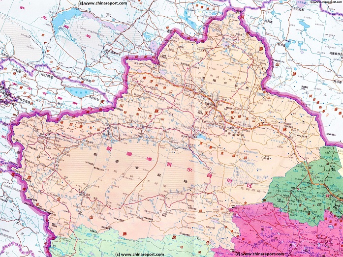
A (dated) Goegraphic Map of Xinjiang-Uyghur Autonomous Region with its main population centers, roads and railroad, connections, airports, and main geographical features.
- CLICK MAP TO GO TO FULL VERSION !!! -
Manas Lake
The lake is however very shallow and measures only 10 meters (11 yards) in average depth. Overall, its features are distinctly flat and it is shaped round as a dish.
Bosten Lake receives water inflow from a catchment area of 56,000 km2 (22,000 sq mi) , 83% of the water in the Lake coming through the Kaidu River, the most important tributary to Lake Bosten. All of which the water carefully managed by central regional authorities.
As the largest fresh water lake in all of China (P.R.C.) even in the more arid conditions of today, during the highpoint of the silk road (some 1500 to 1000 years ago) the Bosten Lake was the largest in a long string of Lakes and Oasis, all of which together supplied the life giving water that sustained the many lives that travesred along the pathways that made up the Silk Road. In fact, in such a barren and dangerous region, wedged between mountains and various deserts, the location of lakes and Oasis helped shape the very paths of that ancient Silk Road. Even today, the main population centers in the Xinjiang Region are situated among the ancient trading tracks that lead into central Asia or China, depending on direction, and those tracks were carefully layed along rivers which had to be available to sustain the many pack-animals of the passing caravans. Not to mention their owners and riders.
From Bosten Lake, an Oasis abundant in fish, crab, shell fish, flocks of birds and miles of green, one could travel eastward through Hami (Kumul) to end up at the equally lush Lop Nor (dried out in +/- 1910). In the opposite direction one could follow the the Tarim River upstream to end up, eventually at Kashgar.
To the North and North-West lie other trading routes which lead into Kyrgyzstan, Uzbekistan and Kazakhstan. Thus, in ancient times, Bosten Lake was a pivotal point along the route, a place to rest, recouperate and prepare for what was next for all. For this very reason it has become famous through time as the 'bright pearl of (all) the Oasis'.
A fishery exists on the lake and fish such as Bullhead and Blunt-snout bream are native to the lake. Westerners sometimes refer to it as the 'Oriental Hawaii of Xinjiang' because of its unique lush scenery surrounded by the harsh Gobi Desert. For this very reason it is popular local, if not regional, destination for leisure seekers.
According to sources, Bosten Lake was developed as a tourist destination in the late 1980s, when a warf and pier was constructed with wharf (at A Hong Kou) where you can look over the beauty of Bosten Lake. Later additions, stimulated by the local government, eager for more tourist dollars and yuan were the sand sculptures of Bailu Zhou (Egret State), and the volleyball facility at Jin Sha Tan - the Golden Sand Beach. Today there are various other attractions and scenic spots.
According Wikipedia, Bosten Lake is sometimes rendered as Bosten, Bosten Hu, Bagrax-hu, Bagrasch-köl, Baghrasch köl, Bagratsch-kul, Bositeng Lake or Bositeng Hu.
The Lake Ulungur is the northernmost lake in the region of Xinjiang, situated between the predominantly Kazakh city of Karamay and the former borders with the Soviet Union, now the border with the Republic of Kazakhstan. With a large surface area of 1,035 square kilometers, the lake is one of China's ten largest freshwater lakes. Lake Ulungur is divided into two sections: Buluntuo Lake and the smaller Jili Lake, both fed by the Ulungur River and other smaller streams flowing from nearby mountains.
In 1969, a canal was built through the watershed between the Ulungur and the Irtysh River in order to divert water into the lake. The winters in the Ulungur Lake region are notoriously harsh. Thick snowfalls block mountain passes and roadways, isolating remote villages.
Once a useful and hospitable pasture land, historically the region was the native home of various nomadic tribes. A favorite tourist attraction of the Lake in wintertime is the traditional ice fishing.
The Ulungur Lake
The Manaus or Manas Lake is the holy lake of the nomadic Kyrgyz and Kazakh Minorities of the Region, much lauded for its live giving waters and astounding natural beauty in traditional Folk Songs handed down through the ages. An outflow of the Ili River, it is geographically and demographically an extension of the Ili River Valley, most of which lies due West across the border inside Kyrgyzstan. The majority of its inhabitants from various ethnic origins mainly Kyrgyz and Kazakhe, it is part of the Ili-Kazakh Autonomous Prefecture and Jinghe' the city on its southern shore is the 2nd largest population center of that prefecture.
The Bosten Lake (Chinese: 博斯騰湖) is the largest fresh water lake in China and the lauded Lake of the Mongolian ethnic groups in these regions. A fresh water lake and ancient life-source in otherwise arid regions, it can be found 57 km (35 miles) due North-East of the somewhat renowned oasis city of Korla (Kuerle), and is part of the Bayin'gholin Mongol Autonomous Prefecture. Covering an area of about 1,000 km2 (390 sq mi) (together with adjacent small lakes), it is the largest lake in Xinjiang-Uyghur Autonomous Region and one of the largest inland freshwater lakes in China entire. Bosten lake today however is largely controlled for agricultural and industrial purposes and divided into two main sections. The largest is 988 square kilometers (381 square miles) with a smaller attachment measuring a mere 240 square kilometers (93 square miles).