Maps of neighboring Nations and Territories such as the Russian Federation, China (P.R.C.), and parts of Manchuria and Siberia.
Relevant Maps of neighboring Nations of Korea
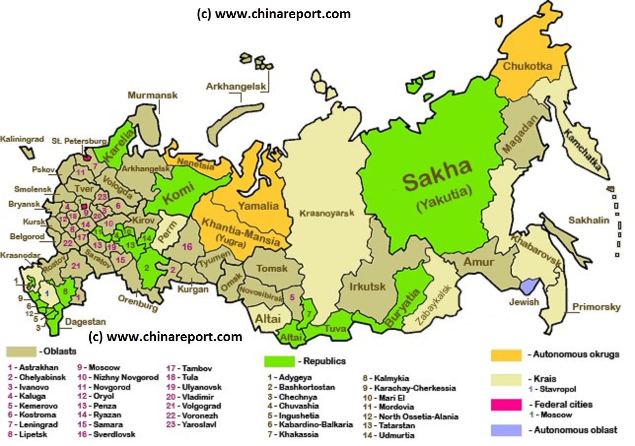
Russian Federation - Political Map - Federal Subject Territories
A schematic Map of Russia and the Russian Federation giving an overview of the location, names and relative sizes and shapes of all Russian Federal Territories. Territories are color coded in order to signify nature. Among the territories are Russia; and 46 Oblasts, 21 Republics and 8 Krai's, and additionally 2 Federal Cities (Moscow), 1 Autonomous Oblasts and 4 Autonomous Okrug.
Not included in this map are territories recently invaded by Russian Forces in northern Georgia (2008 ; Abkhazia and Tskhinvali Region (South Ossetia)) and in Ukraine (February 2014-ongoing), in the latter case primarily The Crimea, which has since been (re-) annexed by Russia Proper.
AsiaReport.com - Korea - Korea Maps on the Web
- Online Sources
Maps of Korea Online
This page was last updated on: 20/8/2017
KoreaReport.comat
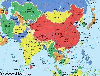
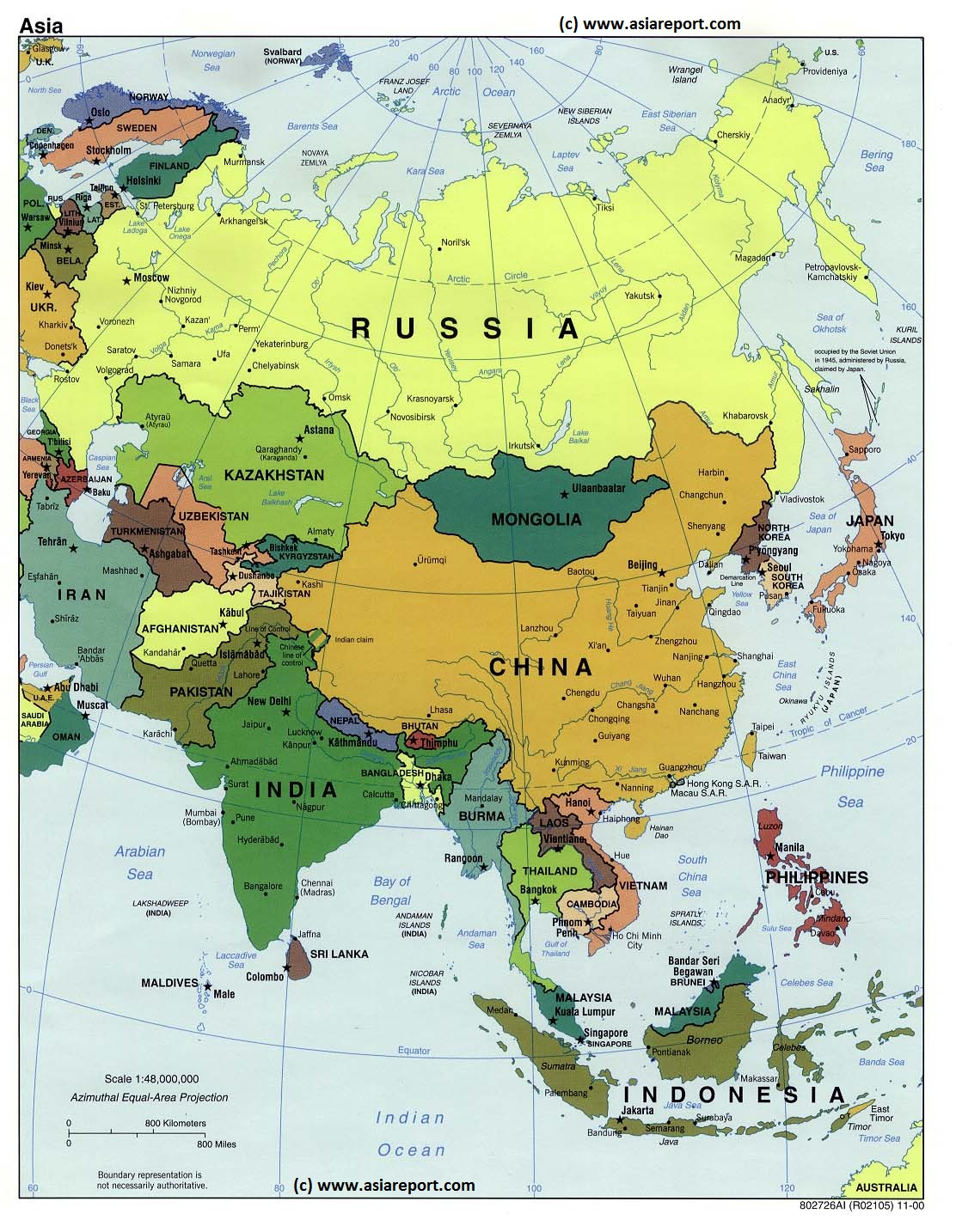
Asia Report - Map of Asia Entire . All Countries, Borders & Capitals
Full Geographical Overview Map of Asia Entire with Zoom & Scroll Functions, Relief Feautures, Oceans, Main Rivers and Capital Cities.
This Map of Asia includes all Asian Countries with Names and Borders, Disputed Border Regions in Asia, Capital Cities of all Asian Countries and Main Rivers and Mountain Ranges.
Click to Go to the Asia Report Main Menu Map, with Zoom and Scroll Functions. Mouse over the Country of your Interest and get short basic information on each Country.
Once more Click through to the Desired Country and Full Information, Photos, Maps and Photo-Virtual Walks of Cities, Towns, Villages, Monuments, Landmarks and Hotspots covered by www.DrBen.Net and www.AsiaReport.com.
SITE INFORMATION UNDER EDITING - MAP AVAILABLE NOW !!
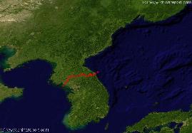
China Report - Jilin Maps - Jilin, Liaoning, North Korea, South Korea Sat. Map
A Satellite Image based Map of the the North-Eastern (Manchuria) Chinese Province of Jilin (with parts of Liaoning Province), the Chinese-North Korean Border, Part of Russian Primorsky Krai (Maritime) Province of Siberia in the Russian Federation, and the Nations of North Korea (DPRK) and South Korea (ROK) on the Korean Peninsula.
Mouse over Map includes the Capital Cities of surrounding provinces and Nations, a rough sketched idea of the location of the Chinese-North Korean Border, the location of Border Towns and rivers, main mountain peaks in Jilin Province, cities and villages, the Yanbian Korean Autonomous Prefecture of Jilin Province in China and last but not least the roughly sketched location of the DMZ, the Demilitarized Zone between North- and South Korea established along the 38Th Parallel.
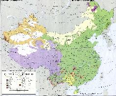
China Report - Map China/Korea Ethno-Linguistic / Language Distribution
A Full and complete Map of China (PRC) identifying all Language Areas big and small in all Provinces and Autonomous Regions of China.
Map includes Turkic Languages (Uygur, Kazakh, Kirghiz, Salar & Uzbek), Mongolian Language and Sub-Divisions (Mongol, Tu, Daur and Dongxian), Tungusic Peoples (Oroqen, Evenki and Xibe) and Languages, Korean, Tajik (Tadzhik), Mon-Khmer (Kawa + Puman (or Pulang)), Hui, Uygur (Uighur), Tibeto-Bhurman Languages, Tai & Miao, Yao & She' Language Area's and Borders. Main Area's and sub-divisions of Han Languages (Northern Mandarin, Eastern Mandarin, South-Western Mandarin and Cantonese) further included. This color-coded ethno-linguistic Map (1967 AD) identifies at a glance most ethnic minority regions in China & includes information on Ethnic Korean Area's.
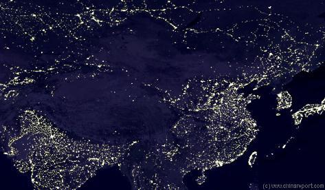
Satellite Image Overview of China and Korea at Night + Cities
This Satellite Image provides an overview of all cities and provinces within the Peoples Republic of China, on the Korea Peninsula and more.
Locations visible lie roughly between Kabul in Afghanistan in the West, Osaka in Japan in the East, Krasnoyarsk in the North and Sanya on Hainan Island of China in the South.
Find the large coastal cities and main Chinese Civilization Centres on the Chinese Plains between Beijing i/t North o/t Plains and Hong Kong, Macau and Guangzhou (Canton) in the Extreme South. Follow the Flow of the Yellow River and cities and towns strewn along it from Xining in Qinghai Province, through Lanzhou, Gansu and Yinchuan, Ningxia to flow along the Western Shanxi Province Border and find the black holes created by the Gobi & Taklamakan Deserts, the Tibet-Qinghai Plateaux and the DPRK.
A Full Google Earth Supported Map of Korea (DPRK, ROK and Yanbian Autonomous Prefecture of China) by Google.com
The Asia Report introduced GMaps on All Levels of its Online Publishing's in April of 2009. Find Google Maps on nearly all Report & Photo Pages where appropriate and useful.
Follow DrBen as ChinaReportcom1 Mobile Device on Google Earth and Tune in via Twitter
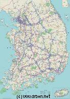
Korea Report - Map of Republic of South Korea (ROK)
An overview Map of South Korea (ROK), depicting all Main Cities, Towns, Highway Connections, Roads Rivers, Sea Bays and Lakes, Airports and Airfields within the Country. Further included are several cities, towns and important locations within North Korea (DPRK), the rough location of the Korean Demilitarized Zone (DMZ) and its maritime counterpart the Northern Limit Line (NLL), the location of various United States and Korean (ROK) Military bases with details of names and stationed units (where available), and a wide variety of small towns and villages in South Korea.
Browse the Map and follow the links to more information on each location, landmarks or monument.
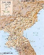
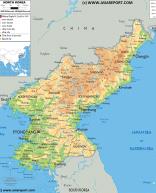
Map of Democratic Republic of North Korea (DPRK) 1A
An overview Map of North Korea (DPRK) created in 1979. This Map inludes Main Cities of North Korea and adjacent regions of South Korea (ROK) and Jilin Province and Liaoning Province of China (PRC).
Further included are Main Roads and Highway Connections, locations of main rivers and mountains, border cities on the Chinese Border and South Korean Border, the 12 main provinces of North Korea, trajectory of Korea's DMZ (De-Milititarized Zone), locations of main historic monuments & tourist sites of the Nation & Region, location of DPRK Main Army and Naval Bases and Yongbion and Yongbion Nuclear facility.
Map under Construction More information to be included soon !!
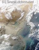
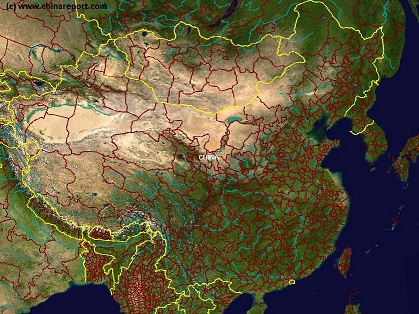
China Report - Satelite Image North-East China, Manchuria, Korean Peninsula
This Satellite Image clearly shows North-East China, Manchuria and the Korean Peninsula, all to varying degrees covered by a Haze of Gobi-Dust Cloud being caried from West to East. Clearly visible are the North-China plains, bordered in the North and East by a semi-continous mountain-range ( Damaqun Shan in the North near Beijing, more south-westernly Guancen Shan near Datong and then further South along the plains Taihan Shan (Luliang Shan ). East of these mountain-ranges are the Yellow River Bassin and the Central Chinese Highlands, the Loess Lands of which are the origins of the Yellow Dust. Covering large parts of Ningxia, Henan, Shaanxi and Shanxi Provinces, the yellow river basin is dry and mainly in spring winds gather the dust. Part of the Yellow River's 5000 kilometer flow can be distinguished and is marked on this Map (Better Map Click Here). Names and locations of main cities in China, Russian Federation, North Korea (DPRK), South Korea (ROK) and Japan are marked. Follow the links where available.
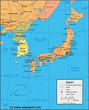
Asia Report - Map Image of Japan, Sea of Japan, Korean Peninsula
This Satellite Image based Map provides a clear overview of most of the Japanese Islands, the Sea of Japan and its Coastline and the Korean Peninsula, including sections of the countries of Japan, South Korea (ROK), North Korea (DPRK), the Peoples Republic of China, and Primorsky Krai Province of the Russian Federation. Marked on the map for orientatation are the names of major National and Provincial Capitals, cities, several towns and villages, oceans, sea's, lakes and rivers, as well as mountains, national borders, and locations of interest.
Asia Report - Map of Asia - Political: The Koreas and Bordering Nations of Asia
A Geographical overview Map of Asia entire depicting the current political borders of Asian nations, national Capitals and provincial Capital cities where possible.
This Map focusses on China (P.R.C.) and neighboring Nations of Central, North, East and South-East Asia with National Borders and National Capitals depicted and linked in.
Bordering Nations of the Peoples Republic of China are Bhutan, Nepal, India, parts of Pakistan, parts of Afghanistan, Tajikistan, parts of Uzbekistan, Kyrgyzstan, Kazakhstan, South-Central and Eastern parts of the Russian Federation including the Republic of Buryatia, the Republic of Mongolia, North Korea (D.P.R.K.), South Korea (R.O.K.), Japan, the de facto independent Island of Taiwan (Republic of China) and further the South-East Asian Nations of Vietnam, Laos, Cambodia, Thailand, MyanMar (Bhurma) and Bangladesh.
Map includes names of all Capitals of all 22 Chinese Provinces, Five Autonomous Regions (Inner Mongolia, NingxiaHui,Guangxi Zhuang, Tibet, Xinjiang), Two Special Administrative Regions and Four Muncipalities (Beijing,Chongqing, Shanghai, Tianjin).Disputed border regions, the Main Deserts of the Gobi and Taklamakan, steppes and basins, Rivers, Lakes, Sea's and Oceans are included.
- Please browse the Map and follow the links to futher information on each location and destination of your choice. -
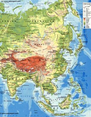
Asia Report - Map Geographic - Relief - Central, East & South-East Asia
A Geographical overview Map of Central, East and South-East Asia. This Relief Map depicts the Nations, Cities and main road and railroad connections.
This general Map focusses on the Republic of Mongolia, The Peoples Republic of China and neighboring Nations of Central, North, East and South-East Asia.
Bordering Nations of the Peoples Republic of China are Bhutan, Nepal, India, parts of Pakistan, parts of Afghanistan, Tajikistan, parts of Uzbekistan, Kyrgyzstan, Kazakhstan, South-Central and Eastern parts of the Russian Federation including the Buryatia and Khakassia Republics, the Republic of Mongolia, North Korea (D.P.R.K.), South Korea (R.O.K.), Japan, the de facto independent Island of Taiwan (Republic of China) and further the South-East Asian Nations of Vietnam, Laos, Cambodia, Thailand, MyanMar (Bhurma) and Bangladesh.
Map includes names of all Capitals of all 22 Chinese Provinces, Five Autonomous Regions (Inner Mongolia, NingxiaHui,Guangxi Zhuang, Tibet, Xinjiang), Two Special Administrative Regions and Four Municipalities (Beijing,Chongqing, Shanghai, Tianjin).Disputed border regions, the Main Deserts of the Gobi and Taklamakan, steppes and basins, Rivers, Lakes, Sea's and Oceans are included.
Please browse the Map and follow the links to futher information on each location and destination of your choice.
A Complete Listing of All Historical Maps relating to the Korean Peninsula, including North Korea (D.P.R.K.), South Korea (R.O.K.) and associated and neighboring regions.
Asia Report - Map Geographic - Japan, Korea, NE China and Russia
This simplified geographic Map provides a complete overview of Korea and Japan as well as relevant parts of China (P.R.C.) and the Russian Federation. Apart from designating the main regions, islands and cities in Japan, it provides an overview of large parts of north east China (Liaoning and Jilin Provinces as well as the southern parts of Heilongjiang Province) as well as the main population centers and a few of the main rivers within this large territory.
The map gives relatively little information on the Korean Peninsula and only a few cities in both North and South Korea are marked on the Map. Barely any information can be glanced from the section of Primorsky Krai Province of the Russian Federation seen in the top center of the image.
Click the accent graphics on the map and follow the links to additional information -
Map of Democratic Republic of North Korea (DPRK) 2A
A more recent overview Map of North Korea (DPRK) created in 2002. This Map inludes Main Cities of North Korea and adjacent regions of South Korea (ROK) as well as those of the neighboring territories of Jilin Province and Liaoning Province of China (PRC). Link through via the map to additional information, maps and photo's on each seperate location.
The Main focus of this Map is for personal travel directions. Further included are Main Roads and Highway Connections, locations of main rivers and mountains, border cities on the Chinese Border and South Korean Border, the 12 main provinces of North Korea, trajectory of Korea's DMZ (De-Milititarized Zone), locations of main historic monuments & tourist sites of the Nation & Region, location of DPRK Main Army and Naval Bases and Yongbion and Yongbion Nuclear facility
Asia Report - Map East Asia - Prefectures and Provinces.
A Satellite Image Map of the better part of East Asia focussing in the Peoples Republic of China and the Republic of Mongolia.
Map depicts all Prefectures within the Peoples Republic of China as well as the Provinces (Aimag) of the Republic of Mongolia. Further included are parts of neighboring nations of Kyrgyzstan, Kazakhstan, Tuva Republic, parts of Siberia and the Russian Federation, both Koreas (North and South), southernmost Japan, Taiwan, Northern Vietnam, Laos, the larger part of Myanmar (Burma), Eastern India (including Sikkim and Aranuchal Pradesh), Bangladesh, Nepal, the Kingdom of Bhutan, Bangladesh and occupied Tibet.
Browse the Map and navigate through to each City Prefecture, Rural Prefecture or Ethnic Minority Autonomous Prefecture within the Peoples Republic of China today. Full names are given where possible. Map further includes location of main cities where convenient for better understanding of Map and Locations.
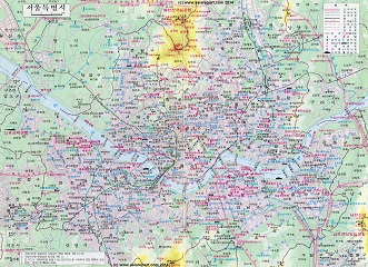
Korea Report - Map of Seoul, Capital of South Korea (ROK)
An overview Map of the downtown area of Seoul, in South Korea (ROK), depicting XX
MAP UNDER CONSTRUCTION !
Browse the Map and follow the links to more information on each location, landmarks or monument.
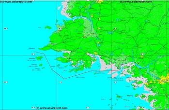
Korea Report - Map of Northern Limitation Line (N.L.L.) - West
A partial overview Map of the maritime border between North Korea (DPRK) and South Korea (ROK), better known as the Northern Limitation Line (N.L.L.). Although accepted by all sides during the Armistice Treaty Negotations, today the N.L.L. remains unrecognized by the Democratic Peoples Republic of Korea, which claims grounds to the south of the Line.
This Map highlights the western half of the maritime border as it is found in the Yellow Sea (West Korea Sea) geographically not too far from both National Capitals of Pyongyang and Seoul.
Marked on the Map are Cities and towns of importance, names of relevant coastal islands, local rivers, etc.
Browse the Map and follow the links to more information on each location, landmarks or monument.
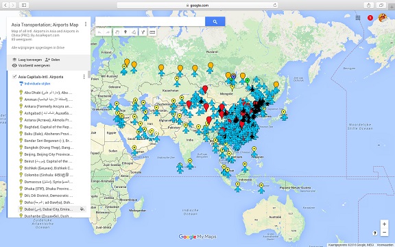
Asia China Mongolia Transportation - Airports & Railroads Satellite Map
This Satellite Image provides an overview of all International Airports in Asia, all Airports in China (PRC) and Mongolia. In addition all military airbases in China (PRC) listed.
Navigate map and click pins for additional information and video where available. Link through from any pin to location information and backgrounds.
Overview all transportation in the Peoples Republic of China and additional Asian Nations in one glance.
Direct Hotel & Resort booking + additional packages linked by location across China, Mongolia and neighboring Asian Nations.