Find all information regading the Town of Hatgal, in
the sub-Chapter: "Hatgal".
- Turt ; a small town situated on the east shore of the
northern tip of Khövsgöl Lake.
Find all information regading the Town of Turt or
Turta, in the sub-Chapter: "Turt".
NATIONAL PARKS:
Khövsgöl Lake.
Khoridol-Saridag Mountains National Park.
Ulaantaiga Bio Reserve.
LAKES / RIVERS:
Dood Tsagaan Lake.
Sangiin Dalay Lake.
MOUNTAINS - PEAKS:
There is no information available regarding mountain climbing in Khövsgöl Province.
MONASTERIES:
- Danzandarjaa Khiid Monastery of Mörön; The Monastery of Danzandarjaa Khiid is modern Mongolian Monastery reopened in the year 1990 when Democratic forces and liberal politics allowed for such. The Monastery is based on the original Monastery of Möröngiin Khuree (Mörön Monastery, the Monastery town upon which the modern Capital was built) which was constructed as late as the year 1890 AD but sadly was destroyed in the year 1937 century and its Monks lost in the various Communist Purges and political crackdowns since. Reportedly, the Monastery held some 200 monks before its destruction.
Find all information regading the city of Mörön including the Danzandarjaa Monastery, in the sub-Chapter: "Mörön".
CULTURAL:
The main Culutural Event in the Province is the traditional Nadaam Festival, which also serves as the Mongoliaan National Cultural Holiday. The Festival is usualy held between July 11 and 13, yearly.
Among the smallest, rarest and also remotest Ethnic Groups (Tribes) found in Mongolia are the Durvuds, Uuls and the Tsagaan (also known as Dukha People). Among things due to their nomadic lifestyle and also the rugged terrain of their usual territories or better, habitats these people are however difficult to find and locate. Traveling to see the various tribes, especially the Tsagaan who live along the (somewhat hostile) border with the Russian Federation, requires preparations for an expedition and special planning upfront.
There is no additional information available on the Landmarks and Monuments of Khövsgöl Province.
History of Khövsgöl Province :
Main Railways and Highways in Khövsgöl Province :
Economy of Khövsgöl Province :
Climate in Khövsgöl Province :
By most travelers standards the Climate in Khövsgöl Province is to be considered extreme. That is, in winter months the average Temperature in the Province is between -24 to -31 Celsius and although the ground and rivers are frozen solid traveling abouts is still arduous and also hazardous at times. Depending on location within the Province and prevailing weather of the time, temperatures can drop to as low as -42 to even -50 Celsius. The coldest months are December, January and February.
In the mountainous north snowfall is abundant in winter and hence access to mountainous tourist area's is closed.
Since winters are cold, rough and usually long up in the north of Mongolia, the main season for travelers to arrive and explore abouts is usually from late spring to late summer (September), after which the cold rapidly return to both the steppes and the mountains.
Average daytime temperature in summer months is somewhere between 15 Celsius and 30 Celsius, although certainly temperatures can soar on a hot and sunny day. The highest temperatures to be expected are around 38 Celsius in the North and 40 Celsius in the south in July or August, a time of year when the sun can literally be scalding to anyone who comes unprepared. At other times, one may be soaked by rain. The rainiest month is usually July with an average of 10 rainy days to be expected in that month and 8 in the succeeding month of August.
Fall is brief across Mongolia, especially in the north. By end of September or at the latest the beginning of October average daily temperatures have dropped back down to freezing point or just below.
Due to prevailing winds from the Eurasian Continent, the air in Khövsgöl is fairly dry and thus precipitation is limited. Average visibility (Horizon) is some 10 kilometers allowing for grandiose views most of the year. Most rain and snow falls in the high mountains found around Khövsgöl Lake in the northern half of the Province eventually feeding life and the Lake through an abundance of springs, streams and rivers. Average annual precipitation in the Province is 300mm to 400mm per year in the north and slightly less in the south (200~300mm) with most of it occurring in the period July to August.
Within Mongolia the Khövsgöl Province is one of the most mountainous territories. As may be expected therefor, it is rich if not abundant in mineral resources. Mineable minerals include coal, phosphate(s), graphite, gold and Iron. Also available are substantial amounts of marble, quartz and lime stone.
The Government listed the average Per Capita GDP in Khövsgöl Province as $ 788, -- in 2010.
Khövsgöl Province or Khövsgöl Aimag is situated in the North-Eastern parts of Mongolia. It has a long border with the Russian Federation in the West, North and East.
Neighboring Provinces (Aimags) and Nations are in clockwise direction - various parts of the Russian Federation in the West, North and North-East, the Mongolian Province of Bulgan in the South-East, Arkhangay Province in the South and finally Zavkhan Province in the South-West.
To be more specific about the territories that lie to the north and across the border of Khövsgöl Province. Outside of the territory of the Republic of Mongolia today, other historic Mongolian Territories are found beyond the borders in the large region known as Siberia. To the North-west of Khövsgöl Province lies the Tyva Republic of the Russian Federation, an originally Mongolian Territory later annexed and dubbed Tyvan Russ.
In addition, originally Mongolian tribal lands and Mongolian culture also extend to the north and north-east of Khövsgöl Province where today the Buryatia Republic of the Buryat Mongolians is a part of the Russian Federation. Historically, the territory of the Buryats extended from the lands around Lake Baikal to at least as far as the Amur River.
The main city of of the Russian Territories north of the International Border today is Irkurtsk, a massive industrial base and regionally important city strategically situated near the gargantuan Baikal fresh water Lake and along the Trans-Siberian Railway.
Introduction to Khövsgöl Province (Хөвсгөл аймаг) of Mongolia
Population of Khovsgol Aimag: 125 thousand 274 (2009) ; 124,600 (2010). In the 2011 census the population was counted as 114,926.
The Population of the main Town and Provincial Capital of Mörön is quite large, with a total of 36,082 counted in the year 2009.
Airports
Mörön - No information available.
(K)Hatgal - No information available.
Main Rivers and Waterways of Khövsgöl Province :
Main Cities & Population Centres of Khövsgöl Province :
By far the largest population center is the Capital of the Province, which is the city of Mörön.
With its own Airport and a population ranging between 36 and 40 thousand souls Mörön is by all means a fairly large city in Mongolia and one of the most important cities and communications nodes in the north and east of Mongolia today.
Additional towns of importance in current day Khövsgöl Province of course are the town centers of its various "Sum" (Rural Districts), the largest among which are the towns of Tarialan, Khatgal, Shine Ider and Khank also Turt(a).
Frequently however, importance in Khövsgöl is not measured merely by size of the town population but equally by location. The more traveled towns of course are found along the major roads, the scenic tourist destination of Khövsgöl Lake and along ancient routes that have historically been established based on experience and convenience of travel through these rugged lands.
Mongolian Tribes declared Independence from the Manchu Throne in Beijing just prior to the official abdication of the Qing Dynasty, which ruling from Beijing had also vanquished all of current day Mongolia subsequently incorporating it administratively and economically into its large East Asian Empire. Thus, the modern history of Mongolia and with it the various tribal territories in the current day Khövsgöl Province may be considered as to have started near the end of the year 1911 AD.
Interestingly, the Darkhad valley (Дархадын хотгор) a part of the realm of the Tsataan (or Dukha) People (See also: Ethnic Groups in Khövsgöl Province) in northwestern Khövsgöl Aimag, today the foundation of the Ulaantaiga Biospehere Reserve was transferred from the People's Republic of Tannu Tuva to the Mongolian People's Republic in 1925 as a Soviet concession to the Mongolians, who had wanted to incorporate the territory of Tannu Uriankhai into their country.
Khövsgöl Aimag was founded in the year 1932 AD along with a new Mongolian Nation.
There is no additional information available on the History of Khövsgöl Province.
There are currently NO railways and no railroads in all of Khövsgöl Province.
Although in the last decades of the 20th century options for mining the phospate found in the mountains surrounding Khovsgol Lake have been considered and accordingly roads have been built, no railways have been planned or constructed in this period.
Nearing the end of the century, all plans for mining in the Khövsgöl Province were cancelled as the Khövsgöl Lake and several nearby territories were turned into National Parks and protected Biosphere zones.
Although development of several mining area's in northern Mongolia is now leading to the rapid construction of a railway to connect the mines of the rugged North-West by rail to the National Capital and largest population center of Ulaanbaatar, no stations are known to be in the planning for Khövsgöl Province.
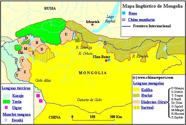
As one may tell from te adjacent schematic Map of language area's in Mongolia, is essentially split into three culturally and ethnically distinct zones which are arranged around the central Khövsgöl Lake.
To the West of Khovskol Lake the language spoken is predominantly Uigur, whereas to the East of the Lake the Buryat Dialect of the Mongolian Language dominates. This is only remote historically determined outcropping of the larger Buryat Language area which extends across the International Border and into the Buryatia Republic, Mongolian lands which today are a part of the Russian
The main body of water in Khövsgöl Province is the large fresh water lake of Khövsgöl Nuur which thus has lend its name to the entire Province. Situated not too far north of the Provincial Capital of Mörön (Мөрөн) and surrounded on the west, north and east side by high mountains, the Lake is the main tourist travel destination within the Province and traditionally also a crucial communications and stop-over point within the northern half of the Province.
The other internationally and historically famous Lake in Khövsgöl Province is the Dood Tsgaan Lake. Unfortunately, this lake has suffered significantly of climatic change and has dwindled in size. In addition to the large lakes, there are many more larger and smaller Lakes strewn throughout the territories of Khövsgöl, in fact too many even for Google to have listed and registered on its maps.
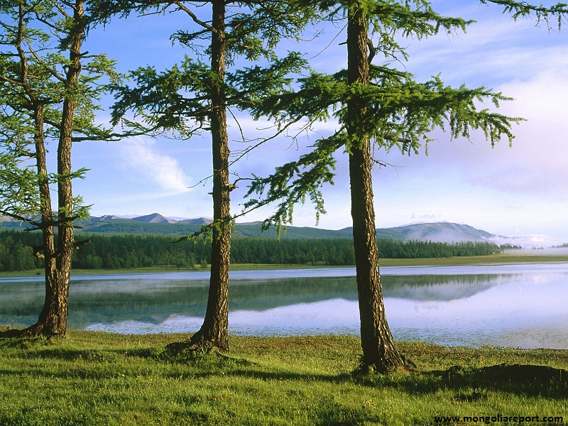
Scene from the Khovsgol National Park in Khovsgol Aimag, Mongolia.
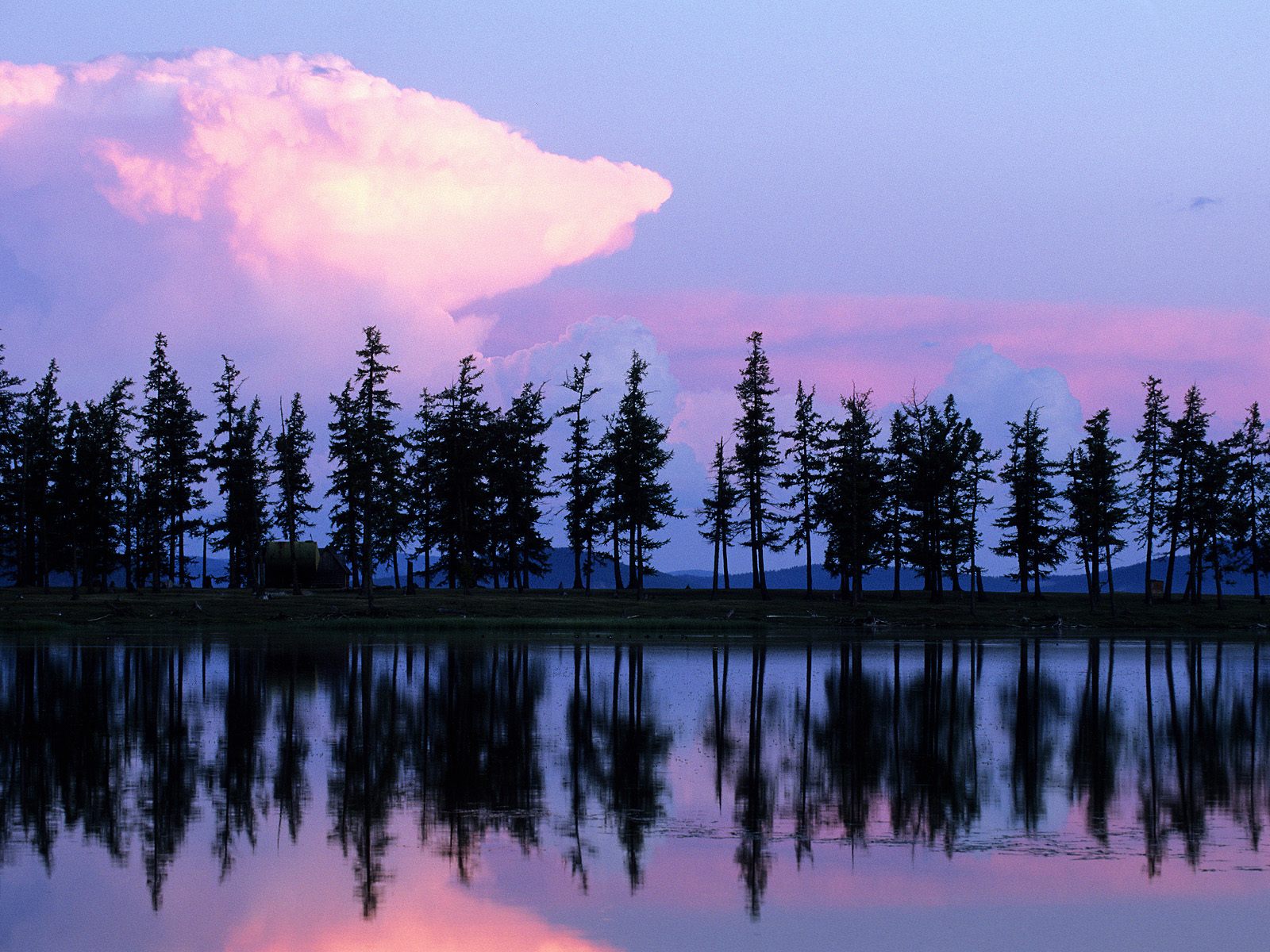
Scenic view of the Khovsgol lake in Khovsgol Aimag, North-West Mongolia. This previously remore province is most popular among International travelers its mountains and pristine wilderness.
For the people of Khövsgöl Province, the nearest town of importance in Buryatia (RFd) is the town of Mondy (also known as Mandy). This town is strategically situated in between the north shore of Khövsgöl Lake on which the town of Turta (Khankh Sum) is situated and Russian city of Irkutsk to the north. Historically the route past Khövsgöl Lake and via Mondy into Russian (controlled) Territories is the most important travel route and connection in these regions, having been established long before there were trains and long before the completion of the Trans-Siberian Railroad through Irkutsk and much further to the north and east, the settlement of Ulan-Ude, today officially regarded as the Capital of the Republic of Buryat Mongols.
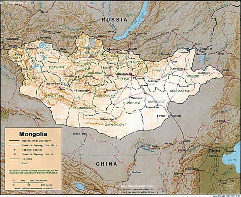
As one may tell from adjacent basic map of Mongolia and neighboring regions and territories, the Khövsgöl
Province itself is mountainous compared to some other parts of Mongolia and is therefor historically remote and traditionally considered as somewhat of a backwater and an off the beaten path destination in Mongolia. Rugged, forrested and mountainous terrain and a sparseness of roads make traveling to and about in Khovsgol Province relatively difficult even today.
Rough climatic conditions which are remarkably different from those found in the central and more desert like Provinces of Mongolia add and additional challenge to travelers and explorers.
Although traditional trading and communications routes passing from today's Mongolia via Khovsgol Lake into Russian Siberia and beyond Russia itself have long existed, in the last 2 centuries the main routes have always passed more to the east (via Ulan Bator), hence until recently very few settlements of size existed in the Khövsgöl Province. Even today in a developing and Democratic Mongolia, only a few major population centers exist in Khövsgöl Province. Except for main city and the Capital of the Province Mörön (Мөрөн) which has almost 20% of the total population of the Province, no other city exists. Most other towns, mostly the sum (rural district) centers dwindle by comparison and even the most popular and largest town of Tarialan does not hold more than 5000 citizens.
GENERAL GEOGRAPHY OF KHOVSGOL PROVINCE:
The Topography of Khövsgöl Province can general be seen as follows; the north of the Province surrounding the name and life giving Khövsgöl Lake is the most mountainous region. Generally speaking, the mountains gently decline in the southern direction until one reaches wide river valley's and even some steppe area's.
The Capital City of Mörön lies roughly in the center of the Province, but slightly off to the south side. At some distance to thee north of the Capital City lies the huge Khövsgöl Lake.
With an an average elevation between1,650 and 2,050 meters above sea level within the Province especially the north knows high mountains and an alpine climate.
Notably, the North of Khovsgol Aimag belongs to Khangai Mountain Region which has various ranges through which a continental watershed line curves its way. Generally speaking, the waters falling along the north side of the Khanghai Mountains end up flowing northward into Siberia and ultimately often to the (north) Arctic Ocean. The precipitation falling on the south side of the range generally flows southward (although often with wild curves) into mongolian Territory. An exception in case seems to be the Khövsgöl Lake itself, the waters of which drain ultimately into the Baikal ake, its larger twin which lies at considerable distance to the north of Khövsgöl Aimag.
The Middle Branch of the (K)Hangai Mountains are noted for the three high peaks of Khovsgol Mountain, Tagna Mountain, and Sayan mountain.
The Highest mountain in the Province is the Delgerhaan in the Khoridol-Saridag Range west of Lake Khovsgol which has a peak at 3,491 meters. Delgerkhaan Uul, Ikh Uul (2961 m) and Uran Dösh Uul (2702 m) are a part of the Khoridl-Sardiag Mountains and Protected Area. Other noteable peaks are Mt. Lam Taiga (2619 m) and Mt. Belchir (3351 m) in the Ulaantaiga Mountains.
Wildlife and National Parks in Khövsgöl Province :
Counted high among the main attractions of Khövsgöl Province are its pristine landscape with mountains and forrest, mountain rivers and according wildlife and flora.
Traditionally the main destination to get a taste of what the Province has to offer is the Khovsgol Lake, which since long has been established as a National Park and wildlife protection zone and ranks as one of the Top tourist destinations within the country.
Essentially, the Khovsgol Lake is a large Alpine fresh water lake.
Additional National Parks in Khövsgöl Province are;
- Khoridol-Saridag Mountains National Park (Protected Area).
The Khoridol Saridag mountains (Mongolian: Хорьдол Сарьдагийн нуруу, Khoridol Saridagiin nuruu) are a 90 km-long mountain range situated enirely in Khövsgöl Aimag of Mongolia. It is found positioned right and between Khövsgöl Nuur and its National Park and the Darkhad Valley, which is home to the Ulaantaiga UNESCO World Cultural Heritage Ulaantaiga Biosphere Reserve. The continental watershed line separating north and west from east runs through the Khoridol Saridag Mountains making it an area of geological and geographical Improtance.
The Khoridol-Saridag Mountain range covers parts of the Renchinlkhümbe, Ulaan-Uul and Alag-Erdene sums. The highest peak is Delgerkhaan Uul (3093m), two other notable peaks are Ikh Uul (2961m) and Uran Dösh Uul (2702 m) with the later situated almost on the shores of Khövsgöl nuur.
These "everwhite" mountain peaks are clearly visible towering above the Khövsgöl Nuur.
The mountains along the Khovsgol Lake are rich in phosphorite, and in the 1980s extensive exploration work was done for open-pit mining. Roads built during that time and other remains, are left as scars on the landscape and are still visible all over the area. Interestingly however, due to the political and economic changes of the early 1990s in Mongolia and the Russian Federation and Central Asia, the mining development plans were sheleved and the ongoing projects were cancelled. Instead of choosing for development, a protected wildlife refuge area covering 1886 km² was founded in the year 1997, by law protecting the landscape, local lifestyles and culture and the pristine landscape so valued by locals and visitors alike.
Today, the Khoridol Saridag Mountains are home to 68 species of mammal including musk deer, brown bear, lynx, marten, beaver, elk, reindeer, moose, argali, ibex and wolf. In addition, the mountains and protected area also the home of a number of the most rare and ethnic groups of Khovsgol Province and Mongolia. Apart from the exotic Dukha reindeer herders who live in teepees and have strong shamanic roots and from Tuvan descent, there are also Duvuds and Uuls people.
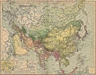
China Report - Colonialism - Growth of Colonies & Japan after 1801 AD
A Map drawing of the Eurasian continent , parts of North-East Africa and the Middle East in the 19Th Century between 1801 AD and 1900 AD. Focal points are the expansion of western colonial posessions of Portugal, Britain and France, as well as Russia moving from West to East. Labeled seperately is the later Rise of the Empire of Japan in the East.
Included in this Map are the main cities across the continent with their brief histories and events during the 19Th Century. Marked in Colors for clarity are the various colonial and imperialist Nations. As relating to China; special attention is payed to so called Treaty Ports. The First Treaty Ports were forced open by Britain in the year 1841 AD, but counted over 80 in total by the end of the 19Th Century. The most important Treaty Ports in China are marked and described with a short history where the map allows.
Language Map schematic of all Mongolian Language Areas and Territories. The Khovsgol Province sits in a location where various tribal areas and the languages meet.
Federation. To complete the image, below the Khövsgöl Lake, in the somewhat less mountainous territories of Khövsgöl Province, the Khalka variant of the Mongolian language is the main language spoken.
A special place and category in the Mongolian Language landscape is taken by The Dukha (Mongolian: Цаатан, Tsaatan) People, who, living in the remotest parts of the Nation, still have their own language dialect. This language is however not marked on the available language map schematic.
The Dukha or Tsataan People are a small culture of reindeer herders living in northern Khövsgöl Aimag of Mongolia.
Altogether, among the various tribes or ethnic groups within the Province the Khalkh People (Or Khalka's) are the dominant group which around
This page was last updated on: May 9, 2017
70% of the population is a member of and who are by now pre-dominant in most of Mongolia except for parts in the extreme west, north and north-east.
Of the remaining "minorities" the Darkhad are by far the largest group who, with some 16 to 17 thousand members (16,268 in the year 2000) make up some 13.8% of the total population. By comparison the second largest ethnic group among the population, the Khotgoid count only 1/3 of the total number of Darkhad Mongolians. With 6229 counted in total in the year 2000 they make up a mere 5.3% of the populace of Khovsgol Province. Third in the list are the Uriankhai with some 3000+ members and counting some 2.6% of the total population. The Buriad (Buryat) and even more so the Tsataan (Dukha) are regarded splinter groups. With some 0.84% and 0.23% of the population respectively they are a rarity in Khovsgol Province.
Naturally members of the Buryat Ethnicity can be found north of the border in the Buryatia Republic of the Russian Federation. However, the Tsataan have virtually no counterparts and are considered a critically endagered nomadic culture, especially so due to their unusual reliance on reindeer as their main animal.
Other splinter groups such as the Durvuds and the Uulds seem to have disappeared from the statistics altogether.
inaccessible even by Mongolian standards. The Darkhad valley is divided between the Ulaan-Uul, Renchinlkhümbe, and Tsagaannuur sums. Inhabitants are mainly Darkhad (whom the valley's name derives from), and also some Tsaatan.
Beyond the International Border, the Ulaantaiga extends further to the south-west, west and also northern directions in the Tere-Kholskiy rayon (District) of the Tyva Republic of the Russian Federation, however only a small part of the Ulaantaiga found within the Tuva Republic is recognized as a protected area. The "Russian" and Mongolian parts of the Ulaantaiga are seperated from eachother by the border river of Tarisïn Gol (River), a substantial stream also identified as Ikhe Tayrigin Gol or Ikhe-Tayrisin Gol, Ikhe-Tayrisin-Gol or also Kys-Tarys, Tairis River, Tayris or Tayris River and Yihe Tayrisiin Gol. The Tarys River is considered the ultimate or at least remotest
source of the Yenisei River, which flows northward towards the Arctic Sea.
The first "National Park" or protected area found across the Mongolian border within Tuva was established in the year 1982 as the Tarysskie istochniki National Monument. With only 105 Square Kilometers in surface area, this was however but a narrow region with a much smaller surface area than the Ulaantaiga Biosphere Reserve found in Mongolia.
By now a second much larger zone has been added to the original Tarysskie istochniki protected area. Extending to the south of Tarysskie istochniki, this zone goes without name at this time and is Internationally identified as Site 89, or WDPA ID 209787 Protected Area.
The main and only apparent settlement in the remote Russian (Tyvan) counterpart to the Ulaantaiga Bio Reserve is the village of Tarys-Arzhan or Arzhan-Tarys, also Tajrisin-Arshan or Tayrisin-Arshan (Тайрисин-Аршан). This settlement is situated on the eastern bank of the Tarys River and found at Geographic Location: 50.3767°, 98.1925°.
Species of Ulaantaiga Bio Reserve: The Park is especially noted for its rare Reindeer.
- the Ulaantaiga Bio Reserve.
According to Wikipedia and various encyclopedia the Ulaan Taiga (Mongolian: Улаан Тайга, literally meaning "red taiga") is a mountain range in northwestern Khövsgöl, Mongolia. This region or area is found between the Darkhad Valley and Mongolia's border with the neighboring Tuva (Tyva) Republic, a Mongol inhabited part of the Russian Federation.
The Ulaantaiga Bio Reserve was established as a UNESCO World Culturul Heritage Site and a strictly protected Biopshere in the year 1990 AD with the aim of protecting the head-waters and source regions of locally important rivers and their often unique flora and founa. Having provided a home and life to the nomadic peoples of the region for millennia, the protection also extends to local cultural and historic sites, artifacts and objects.
Altogether, the Ulaantaiga Mountains cover parts of the Ulaan-Uul, Tsagaannuur and Bayanzürkh sums of Khövsgöl Province. Notable peaks of this range include Mt. Lam Taiga (2619 m) and Mt. Belchir (3351 m). There are 300 small lakes in the Taiga.
The Shishged River and the important Delgermörön River have their sources in this area and so are part of the Ulaantaiga Bio Reserve. Initially only a part of the area along the border with Tuva has been put under natural protection and made part of the Ulaantaiga Bio Reserve. However, as recently as the year 2011 the protected area of the Ulaantaiga Bio Reserve was enlarged. The Park and protected regions added an additional 1,074,661 acres all of which has by Law been converted into a Strictly Protected Area in 2011, creating a total protected area of 4316.94 Square Kilometers.
Most visitors to the Ulaantaiga Bio Reserve pass through the Darkhad Valley as this is the easiest and most convenient entry-point and also an important part of the scenery of the National Park. The Darkhad valley (Дархадын хотгор) is a large valley situated between the Ulaan Taiga and Khoridol Saridag Mountain ranges situated at an altitude of about some 1600 meters above sea level. It is about 160 km long and 40 km wide. The area is 4270 km². Initially regarded as part of Tuvan (Mongol) Territory and thus falling under Russian Jurisdiction the entire valley became Mongolian National Territory in the year 1925 when the valley was transferred from the People's Republic of Tannu Tuva to the Mongolian People's Republic as a Soviet concession to the Mongolians, who had wanted to incorporate the territory of Tannu Uriankhai into their country. Although the transfer occurred now almost a century ago, the Tuvan language (dialect) is still regarded as the dominant language within the sparsely populated valley and all territories to the west of it.
The Darkhad valley is rich in lakes and rivers, the biggest of which are Dood Tsagaan Lake and Shishged River, respectively. The area is famous for its natural beauty, but relatively remote and
In addition to the many lakes found, fresh water is found in abundance for those who know where to find it. Several large rivers flow through the Province and, due to its mountainous terrains with high snowy peaks, a multitude of smaller rivers and streams are found strewn throughout the various sum of Khövsgöl. Altogether there are some 400 rivers and streams to be found within Khövsgöl Province.
The main rivers to remember within the northern half of Khövsgöl Province and the Khövsgöl Lake are all derived from the Mountain Ranges surrounding the Khövsgöl Lake. Flowing southward from the continental watershed line which curves through the mountains north of Khövsgöl Lake, these are the Delger
AsiaReport.com Mastermap of Asia (Entire); includes all of Mongolia and all sites and landmarks within Khovsgol Aimag.
River, The Eg and the Uur River - which after meeting up continue as Eg-Uur River and finally join the Selenge River, the Sharga, the Shishged and finally the Uilgan River.
In the central and southern regions of Khövsgöl Province the main rivers and streams flow from the Khangai Mountain Range. These are the Ider and Tes Rivers, as well as the Bogdgeen (Or Bugdgeen) River.
In addition to the lakes, rivers and streams, the Province of Khövsgöl is especially noted for its many hot and cold fresh water springs, many of which are said to have medicinal and healing qualities. A few renowned hot springs have been turned into what amounts to tourist venue's with sometimes available lodgings. Many other fresh water springs (Hudag) have spawned their very own village, settlement or in bygone days Buddhist Monastery.
The most noted hot springs are the Bulnai (Town) Hot Springs and the Salbar Hot Springs.
Various fresh (or really cold) water springs exist (see available google maps of Mongolia) with the most noted being Dulaan Buleen, Naranbumbat, Khonogtsol and Buustug and Gantigt springs.