Highlights, Monuments and Scenic sites of Inner Mongolia (内蒙古)
Soundbonus - Sounds of Inner Mongolia - Chi Bulag - Jaahan Saarrin Ulger
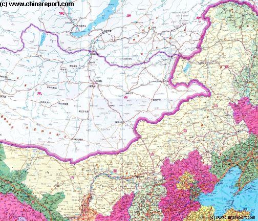
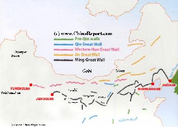
Map Great Wall China - Layers of Dynasties and Era's
A Schematic Map of China and East-Asia, with a super-imposed schematic of the various layers of the Great Wall of China.
Features Pre-Qin Dynasty Wall, Qin Dynasty Wall, Western Han Great Wall of China, the (Northern) Jin Dynasty Great Wall and finally the Ming Dynasty Great Wall as mainly remains today.
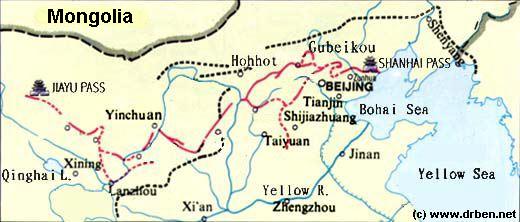
Main Features are Names and locations location of Passes on the Great Wall of China, outer layer and inner layer. Includes Shanhai Pass, Huangya Guan (Yellow Cliff) Pass, JiYunGuan Pass, Ningwu Guan Pass, Pingxin Guan, YaMen Guan Pass, Pian Guan Pass, JiaYuGuan pass, YuMen Guan Pass (Jade Gate) and Yang Guan Pass.
Further included for reference are City names, geographical features of landscape and main mountain ranges. Updates occur several times a year adding new pass locations and photo-virtual tours of Passes throughout China.
Find DrBen and ChinaReport on Facebook with the latest from www.drben.net.
Within the large Inner Mongolia Autonomous Region, landmarks and monuments are few, and often enormous distances lie between special destinations and scenic sites. Until fairly recently sparsely populated and the domain of nomadic tribes, compared to other parts of the Peoples Republic of China there are few historic sites to be found. The few historic Monasteries that were dispersed throughout Inner Mongolia and Mongolia were sadly destroyed during the Communist Era. As a result, tourism and travel within Inner Mongolia is mainly about the wide and varying landscapes; the Gobi Desert, the Steppes and the Lakes and Marshes, and of course - the traditional culture and lifestyle of the Mongolian Nomadic Tribes.
As described, in practice, the Inner Mongolia Autonomous Region can be divided into at least 5 geographically and climatically distinct zones, which helps when trying to get an understanding on which kind of attraction can be found in which region. To review all landmarks, monuments, scenic sites and special locations within the Inner Mongolia AR they are best taken administrative division, meaning they are reviewed below by Region and location.
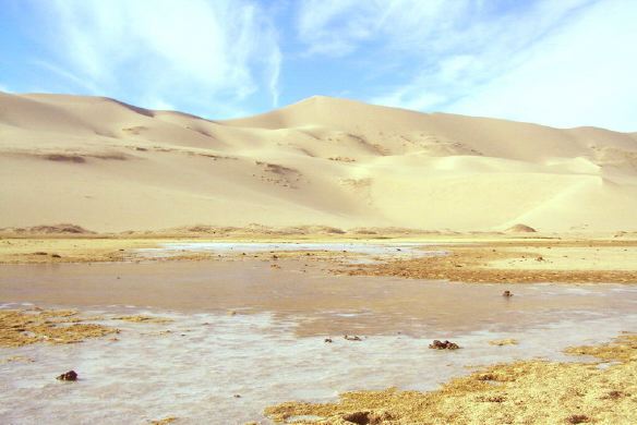
Starting in the West of Inner Mongolia Autonomous Region, the Alxa League is dominated by the Gobi Desert and its landscape. In the past a domain dominated by three large life giving lakes together known as the Ejin Lake (Ejin Gol), which were situated beneath the Tian Shan mountains in the fa west corner of the territory, today's Alxa League is nearly completely arid, the Lakes dried out and the Ejin River usually without water. As a result, many villages have been abandoned, and those that are left cling to life against overwhelming ods.
The South border of the Alxa League is historically shaped by a number of mountain ranges, along- and on top of which stood the Great Wall of China.
Landscape of Sand Dunes along the Ejin River in the Gobi Desert of Alxa League, Inner Mongolia.
Due to the understandable fact that The Great Wall of China is historically regarded as a part of China rather than part of Mongolia and its culture, there are but a few offcially listed historic locations, monuments or special destinations to be found within Alxa League.
(Read more about the Great Wall of China on the southern border of Alxa League in the Section on: 'Gansu Province', and Chapters on the various cities and locations of the Great Wall of China in that Province).
The oldest and most renowned of historical site and monument of the Alxa League is found far west into the Gobi Desert near the former Ejin Lake and is the ruined city of Khara-Koto, in the 13Th Century Capital of the Western Xia Kingdom. Today's Khara-koto is a ruined site near the dying town of Heicheng (Black City).
The second historic site within the Alxa League is known as Base 20, or also the Jiuquan Space Launch Center and is a historic site directly related to the birth of the first Chinese Atomic Bomb, as well as the early development of the Chinese Balistic Missile Program. Located just across the border from Jiuquan in Gansu Province, along the Hei (Ejin) River in Alxa League, the Jiuquan SLC (Base 20) is a popular and recently opened tourist destination, which is however totally off limits to foreign visitors.
No Foreigners are allowed within a wider restricted zone, which by chance also includes the main home of one of China's smallest and most marginalized ethnic minority, the Yugur(s), a people of Tibetan origins. The ethnic village of the Yugur known as The Huangnibao Area/ JiuGuan Yugurs is located within the perimeter of the Base 20 Jiuquan SLC, and is thus cut off from the outside world. Hardly anyone knows what goes on there, nor does any foreigner ever visit.
The Ordos City Prefecture, as its name suggests is dominated by the expanses of the Ordos Desert. Contrary to what is suggested in its name, there are however no real cities in Ordos Prefecture.
The Main historic Monument within Ordos Prefecture are several sections of the Great Wall of China, dating from various era's. The oldest section in or near the Ordos desert is a Q'In Dynasty (221 BC - 206 BC) mud brick wall, remnants of which are hardly distinguishable in today's landscape but still present. However unassuming today, these are the oldest sections of The Great Wall of China available in the world.
Other sections of Wall in the Ordos Desert date to a much later Era, the Ming Dynasty (1368 AD - 1644 AD), which started the rebuilding of The Great Wall of China in this region, after a forward Army of the Mongols once beaten now re-united under the Banner of the 'Northern Yuan Dynasty', returned to the Chinese Border in the years 1451 AD - 1452 AD. After they had set up a base camp on the shores of a lake but some 60 kilometers from today's Yinchuan, they re-started their usual routine of small raids and pillaging. A return of the Mongols, especially to this vulnerable and strategic spot of grassland, raised neckhairs at Court in Beijing, creating quite the discussion of how to handle the situation.
It was temporarily resolved by the local Commander, who in 1453 AD managed to catch the Mongolians off guard, destroying their base camp and leading the remaining army into an ambush annihilating the lot of them.
Source DVD
"Great Explosions in the East - The Story of Two Bombs & One Satellite"
( available from our Online Store )
Schematic Map depicting the multiple layers of the Great Wall of circling Beijing and North and North-East China.
The bloody fate of the entire local Mongolian population provided a brief interval which allowed the building of The Great Wall of China across the Gap in the defenses. Much of what was constructed in 1453 AD and further strenghtened over time thereafter can still be found spanning from Baode - and the Old Ox bend of the Yellow River across the Mu Us Desert of North Shaanxi Province to Yulin Fortress (in Shaanxi) and from Shaanxi via Dingbian (Shaanxi) to Yanchi (Ningxia AR) and from there along the southern rim of the Ordos Desert across to Shuidong Gou just east of Yinchuan, the Capital of Ningxia Hui Autonomous Region. It thus formed in 1453 AD what today is the south border of the Ordos City Prefecture.
This is the main stretch of The Great Wall built in that period. It is however by no means the only section of The Great Wall of China
founded and built in that very year. No, The Great Wall continues further; it curves northward from Shuidonggou to follow the Yellow River (Huang He) to roughly the village of Lasengmiao, forming the western border of the Ordos City Prefecture.
At this point the Great Wall turns West again to run 'horizontal' for a short stretch, forming a Gap in the passes known as Juicai Gou and Dawukou, which form the North Border of the Ningxia Plain of the Yellow River (Ningxia Hui Autonomous Region) with a much more barren landscape of Inner Mongolia. Beyond the wall curves back south to follow the Helan Mountain Range down all the way to the Gansu provincial border.
The other historic Monument or attraction reachable from within the Ordos City Prefecture is the alledged Tomb constructed for the alledged body of Genghis Khan, the Great Mongolian Leader, Tribal King, General and later almost Emperor and still National Hero.
By chance the history of the Mausoleum of Genghis Khan dates back to the same year as the first construction of the Ming Era Great Wall in these parts. Although details remain sketchy, it is know that upon their return and resetllement of the Region in 1451 AD - 1452 AD, the Mongolian Tribes brought with them sacred objects and Gers (Mongolian Tent) which were supposedly related to the dead Khan. Reclaiming their land, and baptizing it in the sense of their beliefs, they first established the site, which today is known as the Mausoleum of Genghis Khan. It was founded and is still situated south of the town of Dongsheng in the Ordos Desert, technically a part of the Baotou City Prefecture.
This Mausoleum or also the 'Tomb of Genghis Khan' is a particularly interesting Museum with an intruguing story attached. That is, today the Mausoleum actually holds a corps, embalmed and mummified remains that came from elsewhere and have long been held to be the remains of Genghis. The body in the Mausoleum or Tomb was not brought here by Mongolian Tribes somewhere after the death of their Greatest leader of all Time. No, for the majority of time - for centuries in fact- it was kept in relative secrecy in nearby regions of East Tibet where it was revered at one of the most sacred Monasteries of the Yellow Hat Sect of Tibetan Buddhism.
The body held at this site in the Ordos Desert, alledgedly of the Great Genghis Khan, was only transported to Inner-Mongolia after the 'Peaceful Liberation of Tibet'. Before that time the body was preserved inside a Hall at the Kumbum Monastery, one of the Holiest Buddhist Monasteries, situated near Xining in Qinghai Province.
Find the Museum and Tomb site in the Ordos Desert outside of Dongsheng, in the southern tip of the Baotou City Prefecture.
READ MORE ABOUT THE TOMB OF GENGHIS KHAN ALSO KNOWN AS THE MAUSOLEUM OF GENGHIS KHAN IN DONGSHENG, BAOTOU PREFECTURE:' Coming Soon !!'.
A Third historic site in the Ordos Desert Prefecture is the place named Red Salt Lake, the now shrivelled and silted Lake which once provided water and grass, the two main ingredients of Mongol Military success. Once the site of Ming military victory, and a massacre of Mongolian women and children, is now but an abandoned place in the desert wilderness. Quite literally, there is nothing much there.
Special destinations within Baotou Prefecture :
Situated above the curve of the Yellow River through the Inner Mongolia Autonomous Region, and perhaps more telling; historically a region well beyond the Ming Dynasty Great Wall of China and thus away from some sort of settled civilization, the Bayan Nur League mainly consists of an arid wilderness. Apart from its adminsitrative Capital Bayan Nur (also: Linhe) the only real urbanized area on the Yellow River, its main population centers are small agricultural type setllements.
Beyond Linhe there a few such agricultural settlements, north and beyond of which lie the Lang Shan mountains which serve to hold back the encroaching sands of the desert beyond.
There are no officially recognized historical landmarks, nor monuments to speak of in Bayan Nur League. Tourism is mainly in the form of 4 wheel drive vehicles which traverse the Gobi and Alashan Deserts.
In a more recent history, the so called Banners or production brigades in this section of China, right on the border with the Mongolian tribal lands, and worse with beyond that the Russian Army, were favored places to send political exiles. Starting as early as the 1950's and lasting well into the 1970's, Bayan Nur League was the home of a variety of 'communes', colonies of the politically condemned who were basicly there to perform slave labor for the State. Within communal villages they, the unwanted, were set a task each day. Usually, who did not work, did not eat. In the views of Mao Zedong, killing people might be a waste, since if their minds were not useful, then they could still contribute their labor to the Socialist Revolution. And so, a large part of the condemned were sent off to remote corners in order to develop land or resources.
Travel by bus out from Linhe or Baotou to visit and see the Communes. They have been dismantled in other parts of China, but within Bayan Nur and other parts of Inner Mongolia, some are still active.
Although not on any tourist itenerary, or available as a tourist tour,
Although not the Capital, the City of Baotou is by far the largest city within the Inner Mongolia Autonomous Region entire. Today stretching along the Yellow River as a gritty and extended industrial town, until faily recently, it was nothing but a small town, a true backwater functioning as a remote gateway into the tribal lands of Inner Mongolia and Mongolia. At that time it was known as a or the "place with deer", and an alternate name in Chinese is "Lùchéng" (鹿城), meaning "Deer City" refering to the local marshes where deer were abundant. As late as 1923 AD, the Wulsin Expedition under auspices of the National Geographic Society, describes at as far beyond the end of the railway line, and a bustling market town on the Mongolian border, emphasizing that beyond lies the unknown.
Modern Baotou (simplified Chinese: 包头; traditional Chinese: 包頭, Mongolian: Buγutu) was essentially built only after the establishment of The Peoples Republic of China in 1949. It consists of an Eastern Urban section known as Donghe (East River) and a Western Section known as Baotou, or West Baotou. Before a walled Chinese town and mere trading station the small settlement of Baotou was turned into the main heavy industrial center situated along the Yellow River during the 1950's and 1960's drive for modernization and industrialization in China (It also became the home of two nuclear reactors). Eversince Baotou has been one of the Coal (and Iron) cities in China, a nuclear center of the nation and of late it has also become the home of China's rare earth mineral industry.
Although thriving economically and home to around 1.9 million, its brief history as a city combined with its heavy industrial background leave but a few worthwhile historical sites to visit. Most are situated well outside of Town.
Baotou is also not a good place to get aquainted with the ethnic culture of the Mongolian People, as in modern times almost 90% of the cities inhabitants is of Han descent.
Baotou City, as does its twin Coal City of Datong in Northern Shanxi Province, has but one real Museum and this one certainly is worthwhile your time spent. Although described as relatively small, the Baotou Steam Locomotive Museum is one of but a few remaining in China entire. Get their early, and preferedly under frigid circumstances to get the best experience. Mind you, off season tours must be arranged by group to keep it interesting for the staff.
Take to the semi-arid desert surrounding Baotou to discover more of its history. In the vicinity there are two Monasteries to visit, as well as as a site known for centuries for its especially spectacular desert landscape.
The most popular tourist attraction of Baotou is currently the Wudang Monastery, which is situated at 67 kilometers north-east of Baotou, amounting to a whopping 2.5 hours driving from Town. Built in the year 1749 AD of the Qing Dynasty (1644 AD - 1911 AD) it is now the most important Monastery of the Yellow Hat sect of Tibetan Buddhism in these parts. Once the home of a legion of some 1200 monks, today's Monastery is active but far smaller. The main treasures of the Temple or Qing Dynasty buddhist murals and the collection of the ashes of the 7 reincarnations of its main Lama.
A second Monastery smaller and less renowned lies about halfway between Baotou and Hohhot, in the north-eastern direction. Situated at about 10 minutes walking from the main highway between the two cities it is often overlooked and rarely visited.
The third attraction and scenic site of the Baotou City Prefecture is the natural wonder knowns as "Resonant Sands Gorge" or "Sighing Sands Gorge". Conveniently located along the road to number four destination which is the Town of Dongsheng, lies a long and barren mountain gorge which has been filled to its rim with sandy dunes.
If one has never seen the sand dunes of the Gobi Desert, this is a good place to go and have a look. For centuries known as a death pit which was said to drown vicitims in its sands, today it is an official tourist destination complete with ticket offices and even a cable-ride to get to the sands. Once there, tourists are offered the option of a quad drive or a try at para-sailing. Naturally there are camels available to take you on a tour of the 90 meter sand dunes. No doubt, more ideas to amuse the visiting tourist will drift down over time.
The Fourth and last main attraction of the Baotou Prefecture is the so-called Mausoleum of Genghis Khan situated near the Town of Dongsheng due south of Baotou on a side-branch of the railway line. It is possible to travel to Dongsheng by road, railroad and since a few years airplane, but for a visit and review of the museum one has to take the bus out of Town to a virtually unidentifyable spot somewhere in the Ordos Desert (S-SW of Town). This is the former Red Salt Lake, where in 1452 AD Mongols desecending from the East Mongolian Tribes (Oirats) reclaimed their ancestral lands in the Ordos reinforcing their claims with items belonging to Genghis the Great Khan. Today, the majority of these items is preserved inside the Mausoleum, which is considered as one of the Holiest Shrines of emerging Mongolian nationalism.
FIND OUT MORE ABOUT THE MAUSOLEUM OF GENGHIS KHAN IN: Mausoleum of Genghis Khan (in the Ordos Desert near Dongsheng, Baotou Prefecture).
Special destinations within Chifeng Prefecture :
Special destinations within Ulan Qab League :
Special destinations within Tongliao Prefecture :
Founded in the early 16Th Century by the famous Shanxi Merchant clans as a large and important trading post along the main route into Mongolia and later a military stronghold of the Qing Dynasty (1644 AD - 1911 AD), Hohhot has quite a bit more history than its nearby rival Baotou. Where there are no worthwhile sites to find within Baotou other than its Steam Train Museum, the city of Hohhot - as the Capital- is home to the Inner Mongolia Provincial Museum. The other two sites frequented by tourists are the Xiletu Zhao Temple - acclaimed for its resident 11Th reincarnation Lama- and the Town Mosque (Hohhot Chingzhen Da Si) dating to the Qing Dynasty.
Although the Cultural Revolution raged especially fiercely in Baotou and Inner Mongolia, the local Mosque was spared from total destruction. Today it is the most worthwhile Temple in the city, as the Xiletu Zhao Temple was destroyed by fire (possibly during the Cultural Revolution) and only recently rebuilt. Naturally, the Mosque also serves as the throbbing heart of the Hui Ethnic Community in the city of Hohhot most of whom work and live in the area surrounding it.
The third site of interest is the Inner Mongolia Race-track in the Xincheng District of Hohhot. As the name suggest, this horse-racing and event stadium should be considered the National Stadium of the Inner Mongolia Autonomous Region, and thus it serves as the location for the yearly occuring main event in Hohhot and Mongolia, the Nadaam. Nadaam is the Mongolian National cultural festival held each summer.
Although outside of the Nadaam festival there is usually little activity at the stadium. During the one week long Nadaam event, the Stadium becomes the Home and playground of all ethnic nomadic peoples in the regions. Pay a visit if you can, preferably between July 17Th and the beginning of August, when Nadaam brings real Mongolian nomadic families to town.
Currently the fourth site of tourist interest within the City of Hohhot is the Daqing Shan Wild Animal Zoo which combines with the Inner Mongolia Qingshaonian Ecological Park. A recent addition to the city, it is a -for China- remarkably modern zoo, teaching about animals as well as preservation of the environment.
Find the New Zoo due North of Beijiao Park and the Inner Mongolia Race-track. To get there, follow Tondao North Road, northward beyond the point where it passes underneath the G6 Jingzhang expressway (Toll Road). From there it is only a few hundred meters up the road to the main Gate.
Outside of Hohhot, in the immediate vicinity are two more Temples to visit. These are the Wusutu Zhao in the West, and the Bai Ta - White Pagoda in the East near the airport. The Wusutu Zhao, with its mix of Chinese and Tibetan architecture is the more interesting of the two, whereas the Bai Ta Temple offers a 7 Story octagonal Pagoda dating from the (Khitan) Liao Dynasty years of domination over much of northern China and little else.
The Book 'The Great Wall - the extraordinary history of China's wonder of the world', by John Man, mentions a further interesting Temple, one dedicated to the Mongol Queen known in Chinese (Han) culture as Lady Sanniangzhi and situated ' in Meidazhao, a few miles East of her home in Hohhot'. According to John Man, this Temple dated to the year 1607 AD of the Ming Dynasty supposedly is still in existence today (or was in 2006 when he visited the city). No specific location or directions to this Temple can be given at this time, however.
Apart from the above listed official tourist sights to be visited within Hohhot and regions, there is one main monument that is usually overlooked and which goes completely unmentioned in most of today's travel guides. This monument however is nothing less than the Great Wall of China itself.
Although eroded down by over 2 millenia of wind and weather, fallen into disuse and faded to an unmost unrecognizable shape, the historical signficance of this border wall and monument is so large that it cannot go unmentioned.
Situated to the North- and Northwest of Hohhot are several sections of the (alledged) first ever constructed Great Wall of China; parts of the legendary Wan Li Chang Cheng - the 10.000 Li Great Wall of China built by Q'In Shi Huangdi (Chinese: 秦始皇) (Life: 259 BC – 210 BC), the notorious and dictatorial Leader if the first ever united China. During the reign of the Q'In Dynasty (221 BC - 206 BC) the Chinese had for the first time settled the regions along the top of the main curve of the Yellow River (I.e. around Baotou and Hohhot and up the River). In order to protect their settlements from nomadic raids, it was decided to built two sections of wall in the desert and grasslands, seperating the Chinese from the nomad tribes in the North.
The first of these walls ran from near Hohhot and Baotou to the West and into the natural barier of Ling Shan mountains above Linhe. Parts of this wall, some constructed of mud only, other of mud and stone, were later integrated into the Han Dynasty Wall protecting those regions and cannot be found today.
The second and main Wall however was a mud and stone wall, which started somewhere to the south-west of Hohhot from where it ran through Hohhot eastward for 1000's of kilometers. This enormous wall supposedly lead as far east as the Liaoning Provincial border and beyond to curve around today's City of Shenyang and in fact almost entire Liaoning Province, pass through Tiger Mountain (Hu Shan) - today's (far) Chinese border with Korea, and continue onward to end near the city of Pyongyang, the current capital of North Korea (D.P.R.K.). Today only broken down ruins remain in the semi-desert grassland above Hohhot, but one can still head outthere to retrace this most ancient, and for its length possibly most impressive, of all walls.
Unfortunatly, no guide book nor source book gives precise details of how to get to the prime wall location near Hohhot. The spot is also not clearly marked as such on google maps. It can however be derived from various sources, that it is likely situated along S101
Provincial Road. The only alternative is the S104 Provincial Road situated more to the west.
There are no grasslands (Caoyuan) to be found immediatly outside of Hohhot, but there are some impressive semi-desert landscapes to be viewed as you will find when visiting the above mentioned outlying Temples. To take a tour of the grasslands and get but a small taste of something resembling the traditional feeling and way of life of the nomadic herders on the grasslands one has to book a minimum two day tour, which is possible from Hohhot. Go to local travel agency, your Hotel or CITS Office to book one that is most to your liking. In most cases there are three main area's to choose from: Xilamuren, Gegentala and Huitengxile. The Xilamuren Caoyuan are the most visited at about two hours bus travel from Hohhot City. Gegentala lies but an hour further away, depending on traffic, and Huitengxile at 3.5 hours from Hohhot remains the least visited grasslands area.
Remember, every trade in China means bartering, so in case you are dealing with a private agency, it is not always necessary to agree upon the named price immediatly.
A Special occassion and Festival to be found in Hohhot is the Mongolian Festival of Nadaam. Traditionally the yearly occassion for all ethnic Mongolians to celebrate their culture, heritage and lately again -unity, it is a must see and witness if you have the chance. Mongolian People flock from all over the large Province and beyond to be a part of the gathering, crowding out the Han, erecting a Town of Mongolian Gers on the outskirts of Town and brightening up the streets and festival with their colorful Mongolian dress. It is one of the few occassions for hich these clothes are still worn.
A Nadaam festival is an ancient Mongolian traditional gathering which in modern times includes wrestling, horseracing, archery and other Mongolian Folk activities. Traditionally held at around the time when the grass is greenest in Inner-Mongolia, which varies with the year but is usually in late July or early August, Nadaam is THE event to get a taste of what the Mongolian Culture is all about.
To be a part of it: Make sure you are aware of the correct date of the event. The horse riding track which is usually the center of the activities lies conveniently at about 1.5 kilometers due north of the Town Center.
There are no reported historical Momuments, landmarks or other sites of special interest within Ulan Qab Prefecture. The main attraction for foreign visitors is the Lake Qagan (Qagan Nur or White Lake) (not to be mistaken with the Chagan Lake due west of Songyuan in Jilin Province!).
A location of considerable ecological importance to the local population as well as migratory bird species from all over Eastern Asia, together with nearby Dalai Lake, it provides a vital wetlands that serves as the nourishing waters for most of the surrounding grasslands of the Ulanqab League. Once a fresh water lake, today it survives much reduced in size due South-West of Xilin Gol (Xilin Hot). The best way to get there is from Xilin Hot down along G107 National Road, or from the South through Sanggen Dalai Sumu, along the G207 National Road to Xilin Hot.
Although a long section of the Southern border of Ulanqab League is historically formed by The Great Wall of China, separating Ulanqab in Inner-Mongolia from Shanxi- and Hebei Provinces of China, this monument and landmark is usually considered a part of China rather than of Mongolian territories. Thus all Great Wall passes leading from northern Shanxi Province and northern Hebei Province into Ulanqab League are discussed in the Sections on: 'Shanxi Province' and 'Hebei Province'.
Special destinations within Xilin Gol League :
Special destinations within Da Hinggan League :
There are no reported historical Momuments, landmarks or other sites of special interest within Tongliao Prefecture. For all information on Tongliao and Prefecture please refer to the Chapter:
There are no reported historical Momuments, landmarks or other sites of special interest within Chifeng Prefecture. For all information on the City of Chifeng and its Prefecture please refer to the Chapter: 'Chifeng City Prefecture (of Inner Mongolia Autonomous Region)'.
All information on The Great Wall of China in the Xilao Tu Mountains forming the border between Chifeng Prefecture and Hebei Province and Chifeng Prefecture and Liaoning Province respectively, are organized under the Chapters: 'Hebei Province', and 'Liaoning Province'.
There are no reported historical Momuments, landmarks or other sites of special interest within Da Hinggan League. For all information on Hinggan (Ulan Hot) and Hinggan League please refer to the Chapters: 'Hinggan' and 'Hinggan League (of Inner Mongolia Autonomous Region)'.
To most Chinese, and certainly to most Foreign visitors, travel to Hulunbuir League equals making a journey to one of the remotest and wildest corners of the country. And it certainly is. Traditionally Hulunbuir is not the realm of the Han Chinese, but of the Manchu (Nuzhen), Mongolians and even far wilder tribes. Although part of the Qing Dynasty Empire (1644 AD - 1911 AD), it certainly was no civilized region. During the Sino-Japanese War of 1937 AD - 1945 AD, the invading Japanese found that it was a largely impenetrable region only sparsely inhabited by usually illiterate and primitive tribes of Evenki, Oroqen, Xibe and Daur.
As described in the section on the history of Inner Mongolia, until as late as 1950 AD there were virtually no roads or cities within the Hulunbuir League. The only connections in the region were formed by its ancient rivers and lakes, as well as by the new International Train connection that reached these secluded parts around 1901 AD. Most cities in Hulunbuir, but also in neighboring Heilongjiang Province, were founded only after the arrival of the railway, which sparked off the first sedentary settlements.
Today this forested and hilly region is recognized as the traditional home of the Manchu-Tungusic People, among them not only the Manchu (Nuzhen) who founded the Qing Dynasty (1644 AD - 1911 AD), but more importantly and more interestingly the rare and little known tribes of the Evenki, the Daur, the Xibe and the Oroqen. The latter tribes are among the smallest and most exotic in China, hence their attraction to Foreign and Chinese visitors.
Another attraction of this remote north-eastern corner of the Peoples Republic of China is the Russian influence that is pervasive in these parts. With the modern life in Hulunbuir based in a large part upon the arrival of the China Far East Railway (a.k.a. the Manchurian Railway), the main trading partner in these parts are the Russians who live just across the border formed by the Argun river. With as their main mode of transportation the China Far East Railway, most Markets and Towns frequented by the Russians are set along the railroad. Other Russians emigrated permenantly, becoming part of the Russian (Eluosi) ethnic minority community of the Peoples Republic.
Many tourist take a ride on the train from Harbin in Heilongjiang to Hailar, the Capital of Hulunbuir League, and beyond to the border settlement of Manzhouli, just to get a taste of the Russian Culture and architecture found in these regions.
The Hulunbuir League is also known for its pristine forests and most untouched grasslands of the Innner Mongolia Autonomous Region entire. Again, most use the Towns of Hailar and smaller Manzhouli as jumping off point for a (minimal) 2 day excursion on the grasslands surrounding the scenic Hulun Lake (Mongolian: Hulun Nur).
As most of the regions above Hailar are sparsely populated, forested or swampy and not easily navigated most tours are organized in the westward direction towards the Russian (and Mongolian) border. Travel above Hailar is usually entirely on your own account.
With a population of around 220.000 it is not very large. The main attraction of the City of Hailar are the Evenki Nationality Museum, a unique museum on the proud culture of the Ewenki (and to a lesser extend the other Manchu-Tungusic Peoples) who used to dominate these regions. The second attraction of Hailar town is the intriguing Underground Fortress dating the the 1930's Japanese occupation of Manchuria.
Outside of Hailar are the grasslands of Jinzhanghan and Bayan Huxu, as well as an ancient ruined fortress up near the Russian Border.
The Border town of Manzhouli is mainly known for its Russian architecture and culture, it cross-border trade, the China Far East Railway (the Chinese branch of the Trans-Siberian Railway) and its proximity to the Hulun Nur (Or Dalai lake).