lake and marsh region populated with Mongolians and then back south to the City of Tongliao an throughly Chinese City in the Manchurian Plain of south-east Inner Mongolia.
A third road from Chinese territories into Inner Mongolia and beyond runs in the North-East, traversing the narrow neck that distinguishes the Xilin Gol League from the Da Hinggan League.
In history, this was the main throughfare between the Manchurian Capital of Shenyang, once the base of the emerging Qing Dynasty (1644 AD - 1911AD) , and the lands of their important allies and vasals, the Mongolians. In the 16Th century, the previously nomadic Manchu tribes emerged from Manchuria but captured much of Mongolia before taking the throne over the Han Chinese. Naturally, there was an important and well used road between their Capitals.
Today this historic route is mainly represented by the main highway G203 leading North-East out of Shenyang in Liaoning Province to head directly the city of Songyuan in Jilin Province, near Chagan Lake and along the Songhua River. This now large industrial City is situated on the border of Mongolian and other traditional tribal area's (and along the Manchurian Railway). From Songyuan the ancient route turns into National Higway G302 which runs through the Kerqin Grasslands to the City of Baicheng (Chaghanhot, which also means "white town") which today is a stronghold of Mongolian and other ethnic groups.
From Baicheng the main road reaches as far as Ulan Hot (Hinggan), the Capital of Da Hinggan League in Inner Mongolia. Although the ancient road to Mongolia continues from Ulan Hot through the Greater Hinggan Mountains to the town of Alxan, this is a minor provincial road through mountainous, wooded and sparsely populated regions. Eventually, beyond Alxan the roads are even smaller and must curve north-west around the impassable Numrug Reserve and the Buir Nur (Lake) of Inner Mongolia to head in the western direction and reach Choibalsan in the Republic of Mongolia. Few however do. The region is mainly known for its extensive horizonwide grasslands, remote tribal villages and long abandoned border region.
Few Roads within Inner Mongolia go north of Hinggan (Ulan Hot). In this far North-Western Region of China there are no historic roads or main trading routes to provide a historic frame-work to build upon. In the centuries before, there was only wilderness, mostly large forested regions inhabited by nomadic Manchu & Tungusic Peoples, among whom some notoriously reclusive hunting and fishing tribes.
During the time of the Qing Dynasty Era (1644 AD - 1911 AD) these were the Daur, Ewenki and Oroqen People (who are Manchu-Tungisic people but not (Nuzhen) Manchu's) living a primitive life within the forest. At the same time, there were no real settlements, but only some patches of arable land, mainly worked by people who lived near the few trading posts and military stations set along strategic rivers.
Until as late as the advent of the Peoples Republic of China in 1949, the real traffic arteries of the regions were rivers, not roads, the only exception to this rule being provided since 1901 by the Chinese Eastern Railway (also known as the Manchurian Railway). In between villages and towns there were only forest pathways leading down to Chinese trading settlements. These roads usually became impassable mud pools as soon as the rain set in.
Specifically the Norther tip of Inner Mongolia and the adjacent regions of Heilongjiang Province are notorious for their swampy and boggy grounds, often forming natural borders that later turned into the international borders of today. Traditionally Government control over the population as been marginal, a situation reinforced by large distances, impassable terrain and extreem climate. Even today, the north-east of Inner Mongolia and the Northern tip of Heilongjiang Province remain a sort of wild west type region. Cross border smuggling by the tribes, who cling more to family bonds then to oustide Government oversight used to be frequent, even in the darkest days of Communism.
Noteably, because of the complete lack of roads in the region, from 1901 onwards, this new railway -a strategic branch line of the emerging Trans-Siberian railway leading from Chita on the Trans-Siberian Railway via Manzhouli on the Chinese (Manchurian) border and through Manchurian tribal lands directly to Harbin and finally Vladivostok- became the basic frame-work for transportation in the regions. The first settlements in southern Hulunbuir effectively sprang up along the railway, growing in importance and function as the railway and its economics did. Thus, towns and cities of importance within todays Hulunbuir League are mainly those along the railroad.
Compared to about a century ago, today the transportation situation in these remotest of regions (Hulunbuir League) is dramatically improved. Noteably, because of the complete lack of roads in the region, from 1901 onwards, the first framework for transportation in this north-east corner of Inner-Mongolia was first provided by the Manchurian railway -a strategic branch line of the emerging Trans-Siberian railway. The first settlements in southern Hulunbuir effectively sprang up along the railway, growing in importance and function as the railway and its economics did. Thus, towns and cities of importance within today's Hulunbuir League are mainly those along the railroad.
Based upon these railroad towns, roads then emerged.
Currently there is only one main road within North-East Inner Mongolia's Hulunbuir region. This is is G301 National road, forming the main route connecting from the south-east (QiCha'Er and China) to Hailar (Hulunbuir), the now unlocked Capital of Hulunbuir League and main city on the East China Railway (Manchurian Railway). From there it continues on to the border with the Russian Federation at the Town of Manzhouli.
Travel beyond Hailar into North Hulunbuir is traditionally even more difficult, however today this situation is large resolved by the construction of proper paved roads and a regional railway network stretching above Hailar. The main road north from Hailar into Ewenki and Daur territory is the provincial road S201, which eventually leads up to Shiwei (zhen) border town and Olochi village on the Chinese-Russian Border in these very remote parts. The border is formed by the Argun River. small bridge leads across the river and on to the main settlement of Nerchinskiy Zavod on the P-429 road leading south-west.
Either follow the national road G301 / G015 in the direction North-West. At the town of Arun it connect with national road G111, which curves around to the important town of Morin Dawa, the home of Morin Dawa tribe of the Daur ethnic people living in the region.
The other option is the to head North-East out of town of G111 National Road (Yes!) in the direction of Fuyu Town and the city of Nenjiang quite some ways beyond. This main road, the G111 provides the main backbone of road communciations further up to the North. Via Nenjiang, the G111 leads directly to Jiagedaqi (Oroqen: Jagdaqii), the main ethnic home of the Oroqen People living in their traditional homelands in these far northern regions.
After reaching the Jiagedaqi Autonomous County and the Oroqen, one can follow the provincial road westward to Genhe, or travel even further up north by S207 provincial road.
The S207 leading North from Jiagedaqi is the northernmost (main) road in the Hulunbuir League and the whole of Inner Mongolia Autonomous Region. Past remote and small agricultural villages it leads across the border into Heilongjiang Province to connect with Da Hinggan Ling (Tahe).
For more travel details for road travel in Hulunbuir Region read the Chapter on : 'Hulunbuir League'.
Train Travel and Railroad Connections within Inner-Mongolia Autonomous Region :
Transportation & Travel connections Inner Mongolia Autonomous Region :
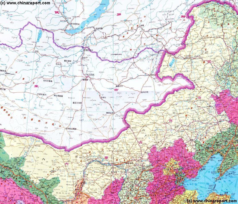
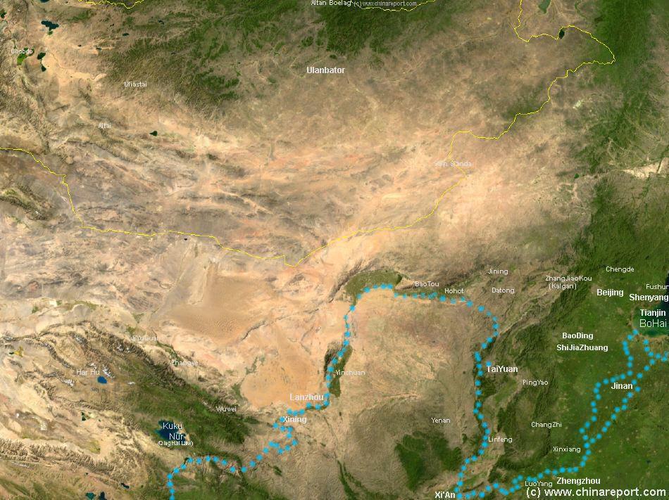
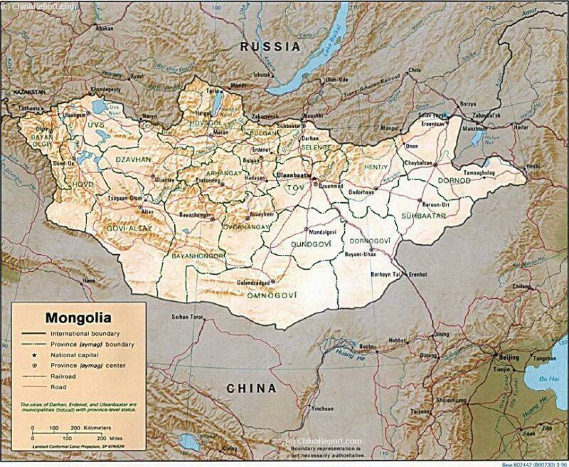
Satellite Image Map of the Gobi Desert Region. Map overviews North-West Xinjiang Autonomous Region, Mongolia, Inner Mongolia and North and North-Eastern China giving a Full Overview of the Gobi Deserts and Yellow River Basin. Map includes country borders, name + location of Cities and Villages (clearly visible).
Discover China in all aspects with ChinaTravel2.0 ! Culture, Food, History, ethnic minorities and off the beaten path locations and sites to visit - China Travel 2.0 has it all and thus offers and brandnew eco-oriented way of travel within the Peoples Republic.
Join DrBen.net & AsiaReport.com exclusive partner for your Travels in China and join a learning experience of your choice !!
Due mainly to the large size of the Inner Mongolia Autonomous Region comprising roughly 12% of the total landmass of The Peoples Republic of China, its dramatically varying landscapes and environments, as well as the previously under-developed nature of large parts of the region, transporatation and travel within Inner Mongolia can be arduous and complicated. Most cities and main population centers are however reachable by road, railroad and lately some by airplane.
With most of it consisting of desert and semi-desert grasslands, traditionally the main thoroughfare for transport in Western Inner Mongolia was the Yellow River, which was passable for barges between Baotou and Zhongwei as far upstream as the Qintongxia Gorge.
Other parts of the the wilderness of Inner and Outer Mongolia were only traversed by the main pathways of trading routes running south to north from China into Mongolia. Further, in the 19th and early 20th century only small roads existed here and there, the more roads the closer to civilization and the Chinese Han settlements. The wildest parts of Inner Mongolia lay in the wooded and mountainous north and in the west was the desert realm of the ordos and the Gobi Desert.
There were no railroads within Inner Mongolia until well into the 20Th Century, the turning point coming with the building of the communist Peoples Republic of China.
Schematic Overview Map North China, Inner Mongolia and Mongolia :
Taken from West to East, the first main road in Inner Mongolia are the road from Datong in Shanxi Province in the South to Ehrenhot -border town with Mongolia- in the North and from there on to the Mongolian Capital of Ulaanbataar (Republic of Mongolia). In history it was the main camel caravan and trading route from the Chinese Capital into Mongolian territories, trading among things tea, silk, ceramics, metal items and other sophisticated Chinese products for animal skins, herbs, salt and other goods. Today this is the National Highway G208.
The second historical road from Han Territory into the Mongolian lands beyond the Great Wall of China and vice versa lies only slightly to the East. It leads from the Capital of Beijing to Zhangjiakou in Hebei Province, better known as Kalgan (in Mongolian language). From Kalgan it leads northward through a 27 kilometer long mountain gorge towards the mongolian steppe plateaux and traditional Mongolian Tribal lands.
Interestingly, Zhangjiakou was for centuries a military bastion and stronghold in support of The Great Wall of China and the gorge was the invasion route chosen by invading Mongol Armies in the 12Th
Schematic geographic overview of North China, most of Inner-Mongolia, the Republic of Mongolia and relevant parts of the Russian Federation. Clearly, the main traffic artery to Mongolia leads from Beijing (Hebei Province) or Taiyuan and Datong (Shanxi Province). In Manchuria, the North-East, further connections lead to the Mongolian Capital of Ulaanbataar, or directly into Russian territory. As shown, large parts of Inner Mongolia have no large towns nor roads.
As a general note: main airports within inner Mongolia AR are reachable via Beijing Capital International Airport, Shanghai, and other large cities. Distribution to smaller local fields goes via Hohhot, the Capital of the Autonomous Region and Baotou.
The main airports within West- and Central- Inner Mongolia are Wuhai, Baotou and of course the Capital Hohhot. Recently the Ordos City Prefecture also developed its own National Airport near the administrative Capital of Dongsheng (东胜区). Reach Dongsheng via Hohhot or Baotou, but also via regional airports such as Yinchuan in Ningxia Hui Autonomous Region and Yulin (Regional) Airport in North Shaanxi Province. Other options may be available !
For full details read the Chapter: Transportation in Inner Mongolia Autonomous Region.
In the North there are Hinggan National Aiport at Ulan Hot (Wangyehmiao, and even more to the the north (Manzhouli) and Hailar (Hulunbuir) National Airports in Hulunbuir League.
Flights connections, Air travel and airports within Inner Mongolia AR :
Main roads and highways within Inner Mongolia Autonomous Region :
Since their advent in China in the early years of the 20Th Century, trains have been the main mode of transportation in China, both for goods as for people. And things will likely remain that way, regardless the large expansion of airports and air travel within China. From those early years on, a large railway network was strung across (mainly) the central regions of China serving industrial, military and other functions. However, outlying regions, mainly sparsely inhabited border regions with little commercial value remained unconnected.
Today's transportation network within Inner Mongolia still very much reflects these bygone days. That is, there are but a few roads spanning the gap between Chinese Civilization, the Mongolian Territories and The Russian Federation beyond.
Century.
Today the road through Zhangjiakou (Kalgan) is an important highway thoroughfare for coal and ore trucks hauling the mineral wealth of Inner Mongolia and Mongolia down to Chinese factories for fuel and raw materials. Once the domain of camel caravans it is now the G207 national highway notoriously clogged with 1000's of dusty dump trucks.
Follow the road from Beijing to Zhangjiakou, either to head north-west and join up with G208 (Datong-Ehrenhot) through Jining, or head north and north-east along G207 to reach the city of Xilin Hot in the heart of the Dornod Mongolian Steppe of Xilin Gol League.
Due to the presence of the Gobi Desert to the North, the highway G207 and road ends at Xilin Hot. From Xilin Hot, further provincial roads lead in two directions. The first east to Ehrenhot (Elin) (S101, followed by S309), or the other to bend north-west and curve through an ancient
Thus, the railway that already connected Beijing and the rest of China to the Capital of Shanxi Province at Taiyuan, was extended northward to reach into Inner Mongolia via Datong and then Jining, providing a first railroad into Inner Mongolia. Even today, this is an important railroad, connecting from China's Capital, via Datong to Hohhot, the Capital of Inner Mongolia.
Based upon this first branch, further connections became possible.
Still full of zeal and enthusiasm from what seemed to be the succesful resurrection of a fully independent China, Chinese across the nation embarked on projects which had previously seemed impossible or to expensive to try. Among these was an ambitious project which proposed to build a railroad across the Gobi Desert, connecting Hohhot and Baotou, the end of the railway in Inner Mongolia, with the Grain Fields of Ningxia and the emerging Industrial, military and logistic Capital of the West and ancient Silk Road city, Lanzhou.
Between 1953 and 1958 construction progressed, leading
to the opening of a new project of National Pride, the so-called Baolan Railway. The Baolan Railway, still a major backbone of railroad network in Inner Mongolia follows the Yellow River upstream from the heavy industrial city of Baotou, providing an alternative and more efficient transport link for goods (coal, iron, minerals, ore) up and down the River and beyond the otherwise impassable desert.
Noteably, it was also the first ever railroad connection transporting Chinese people across the width of Inner-Mongolia. Many would soon go, starting a process of Han migration into Inner Mongolia that is still ongoing today. Today the Baolan Railroad remains the only railroad traversing the Western expanses of Inner-Mongolia.
The next important, and historically second railroad connection within the large Inner-Mongolia Autonomous Region matches the historic Silk- and Tea- northern trade route into Mongolia and Russia.
Historically based upon a Gentlemans agreement between the Russian and Chinese Courts, this route leads from the Chinese Capital of Beijing, via several available passes of The Great Wall of China into Inner-Mongolia and via the ancient trading post of Ehrenhot on to Ulaanbataar in Mongolia.
Today, the south section of this route is represented by the train routes Beijing-Zhangjiakou (Kalgan = Heaven's Gate) to Jining and its twin line, the route Beijing-Datong to Jining.
From Jining, the line extends directly north to extend across Inner Mongolia to the border at Ehrenhot and beyond to Ulaanbataar.
Importantly this section is the main railroad artery within Central Inner-Mongolia (Hohhot and Ulanqab Prefectures). Furthermore, having been connected from Ulaanbataar to the Russian City of Irkutsk on the Trans-Siberian railway, it is now an important international train route. Considered a main branch line in these parts, its provides the only link with Civilization for many on the Steppes of Mongolia and far flung regions beyond. Withouth the railway line, there would be no towns of the steppes. The line also served vital military functions, especially in the time of the Soviet Union (C.C.C.P.) when the railway line served as the main strategic backup for frontier military bases and the 1 million Russian troops and tanks deployed on the Chinese border in the 1960's and 70's.
Other main railroad lines within Inner Mongolia run far further to the East, again following the traditional trade routes that had already lasted over the previous millenium. This means that in the Far eastern Manchurian regions, the industrial city of Shenyang (historically: Mukden), already an important center on the South Manchurian Railway (south branch line of Manchurian Railway Chita-Manzhouli-Hailar-QiCha'Er-Harbin-Vladivostok) was further connected to Tongliao in Inner-Mongolia and Baicheng (Changanhot) in Jilin Province. Initially this provided a railroad connection from the emerging heavy Industrial Centers of the Manchurian plains along the Manchurian railway, with the raw materials needed found just beyond in the previously under-developed regions of Xilin Gol League and Da Hinggan League of Inner-Mongolia.
Only later this line was extened to lead to Hailar, a previously cut of tribal City in the grassy and forested expanses of Hulunbuir, Inner Mongolia's wildest region. Today these railroads form the main frame of the railroad network within North-Eastern parts of Inner-Mongolia.
The fourth main railway line within Inner-Mongolia should be considered the line from Qiqaha'er westwards to Hailar and from there to Chita in the Siberia Province of the Russian Federation.
!!!! Based upon the Manchurian Railway line itself, which travels from Shenyang directly north to pass through Changchun - Capital of Jilin Province, and Harbin - Capital of Heilongjiang Province to Vladivostok on the Sea of Japan, the line Qiqaha'er to Hailar and through to Chita is considered the second mian branch line of the Trans-Siberian Railway to emerge after the historic Manchurian Railway, and is thus the last pillar of the Inner Mongolian Railroad network. All other railroads are based upon these, connecting various crucial population centers and towns within the large expanses of its territory.
Xilin hot
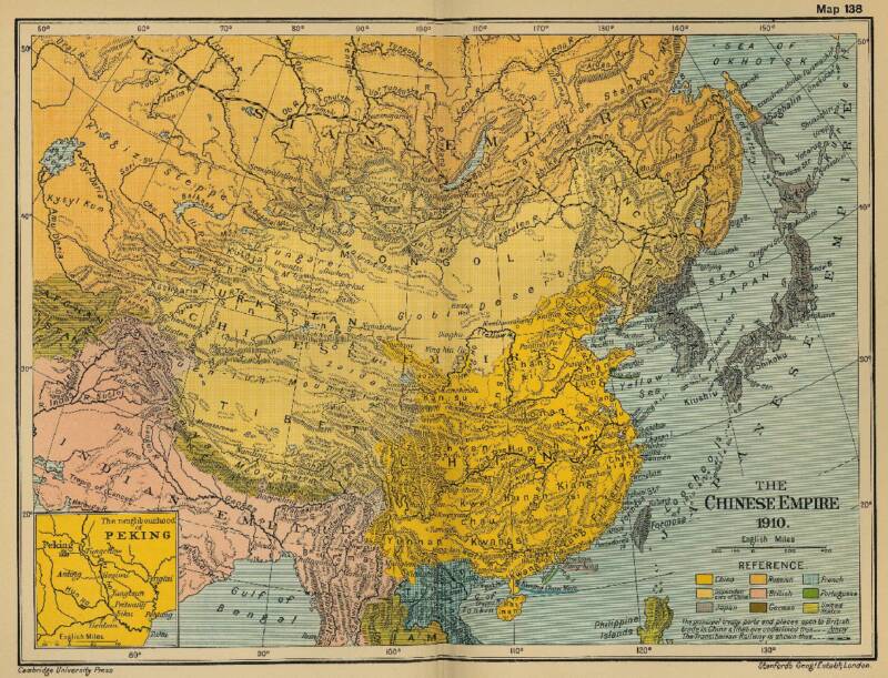
Historic Map - China (Qing) Empire in 1910 AD
An obviously non-Chinese but western-inspired and made Map of the Ching Dynasty Chinese Empire in the year 1910 AD, a year in which China's sovereignty has been under threat and siege for over 70 years.
In this Map of 1910 AD, made one year before the abdication of Last Ching Emperor Xuan Tong and the final end of China's Feudal History, China is depicted as in it's smallest boundaries and definition. Most notably Manchuria, and Inner Mongolia, both territories nominally under Chinese Control and under Chinese Sovereignty are depicted as separate area's. Manchuria is the ancestral home of the Aisin-Gioro Clan of the Ching Dynasty.
Other interesting features of the Map and geography of the Time : after the Sino-Japanese war of 1899 AD, both Korea and the Island of Formosa (now Taiwan / ROC) have been annexed by the Japanese Empire.
Treaty Ports, around 80 in total dot the Map of China.
As for Inner Mongolia, By the end of the reign of the Qing Dynasty (1644 AD - 1911 AD) there were no railroads in the entire region. The only railroads then available ran to the coal mines of northern Shanxi Province, from where travel into Inner Mongolia was on foot or camel or horseback.
Far to the North however, the Trans-Siberian Railway, a now renowned train route was constructed between 1891 AD and 1916 AD, connecting Irkutsk, Ulan-Ude, Chita and Khabarovsk to Vladivostok on the Sea of Japan. Later, a branch of Trans-Siberian Railway would be connected to Shenyang in Manchuria, creating the branch line of the Manchurian Railway which did not run through North-East Inner Mongolia but through traditional Han Chinese territory.
In other words, one could only reach the borders of Inner Mongolia by train. But, that was it.
This situation essentially only changed with the further industrial development of China, which occurred after the establishment of The Peoples Republic of China in 1949 AD.
A newly arising a modernizing, non feudal China would have to be an industrial state, so everyone agreed within the top ranks of the leading Communist Party. Thus throughout the 1950's, China embarked on massive and perhaps overzealous effort to build factories across the Nation, creating, jobs, fueling the economy and creating a need for materials. As a result, Inner Mongolia, beforehand considered mostly a buffer region with the (unfriendly)
Russian neighbors (as it had been for centuries) suddenly became a region of vital economic resources. Suddenly, a grand scheme was hatched for the development of (worthwhile) regions of Inner Mongolian territories, mostly resulting in railroads to connect with the coal and Iron resources found there.
Only later direct links with other cities in Inner Mongolia and beyond to Ulaanbataar and Irkutsk became available.
Considering this brief history, the current railroad network in Inner Mongolia, especially the routes of main lines are easier understood.
Expanding upon the then existing railroad network, and based upon historic trade routes with the northern neighbors, new railway lines were drawn in the 1950's and 60's. The first railway projects were considered vital economic projects, meaning they had to extend to the mineral riches of the Gobi Desert of (mainly) central Inner Mongolia. There were military considerations as well.