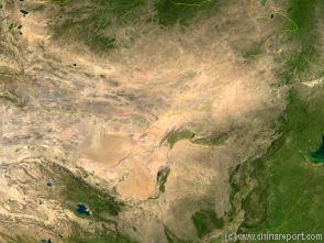
China Report - View o/t Tarim River Delta - Lop Nor dried lake area in Xinjiang AR
LOP NOR IN THE NUCLEAR ERA :
Much changed in China during Mao Zedong Era, and regardless of its extremely remote location, change came to the Lop Nor and area as well. In fact, at the time, exactly the remote location and lack of population density around the long empty lake became the main attraction of this spot for the next set of events that would bring it more fame. Or notoriety at least.
Starting in the 1950's, the Lop Nor was used for altogether very different purposes than giving and sustaining life. The former Lake Bed, historic place turned empty desert, was judged to be the ideal, secret and ultra-remote, out of the public eye, testing ground for China's self-developed nuclear weapons (and their ballistic missile delivery systems). Possible other notable factors, less easily explained, (may have) weighed in as well. That is, firstly, the Lop Nor, technically and historically lies just outside of what has always been regarded as ″True″ Chinese territory, aka the border of historic Chinese heartland (Illustrated by the construction of the Yumen (guan) - Jade Gate (pass)Toll House during the Tang Dynasty (618 AD - 907 AD) outside of Dunhuang and due East of Lop Nor Lake, and again -less accurately- by ending of the Great Wall of China at Jiayuguan during the Ming Dynasty (1368 AD - 1644 AD).) Thus, as will have been due registered by a person which such historical awareness as Mao Zedong, the Lop Nor historically) was not considered part of China. A good place to, as Mao Zedong may have put it, let out a giant fart.
Furthermore, secondary to the remoteness, the climate and other factors explained, most of the inhabitants of the region are not of Han ethnicity. Thus, they may have been considered as not really Chinese, and given the frame of mind of the days, been considered as fairly expandable.
Whatever the considerations may have been in reality, the Lop Nor regions were chosen to be used for secretive military purposes and soon a variety of nuclear facilities was set up at- , in- and around the Lop Nor region.
In the following 20 to 30 years virtually no one in China knew about the existence of any of these basis and outside of China but a few people were aware. The Lop Nor nuclear facilities and other supporting bases were however no longer a total secret due to mainly secret overflights by U2 Spy Planes. The United States of America was already attempting to spy on the bases, and naturally, being involved with the early founding of the Chinese nuclear program and work on the ground, the Soviet Union had a fairly good hunch where the base was to be found.
In 1964 AD, under the careful monitoring of both the Soviet Union and the United States, the Lop Nor became the nuclear testing site where China detonated its first nuclear weapon.
This first Chinese nuclear explosion, dubbed project 59-6 in the West ,was an atmospheric blast which occured not inside the Lop Nor lake basin but at a site further eastward in the (Inner-Mongolian desert).
The first nuclear detonation that occurred in the lake bed itself (Malan Base) was achieved during the 3rd Chinese Nuclear test, which (according to U.S. information) occured on May 9 of 1966 AD. This test, dubbed CHIC-3 by United States Intelligence, consisted of an Atmospheric Test of an air-dropped bomb of the layered cake design derived from the soviet union.
The bomb was caried aloft by a soviet built bomber adapted for the task and subsequently dropped in the Lop Nur area of Xinjiang yielding a massive 250 kiloton explosion.
While the explosion left a giant mushroom cloud hovering over western China, the event was great news in Beijing. Again, on Mao's express orders, the scientists of Malan, and Jiuquan (Dongfeng) Base in neighboring Gansu Province, together with several Chinese Universities around the nation had succeeded in making dramatic progress. It was an unprecedented blast and China could be secure in its rise as one of the worlds nuclear armed nations. As many saw it, finally the nation would be able to withstand any 'Imperialist' outside force, forces that had so wreaked havoc on the nation in the previous 100 years.
Historically the Lop Nor was known as a crucial stop over point on the so called ″Silk Road″, a network of trading routes that came into existance at around the 2nd and 1st Century B.C. and, when in due course of time further developed, connected China with Central Asia, and Africa, Arabia and Europe beyond. Fed by China's 5th largest River, the Tarim, the Lake Lop Nor was a refreshing, salty but still life giving lake of a fairly substantial size which was rich in fish, bird and game that, together with the river formed the basis of what is known as the Northern Route of the Silk Road (within China).
As a fresh water lake surrounded on two sides by vast desert-like regions, the Lop Nor formed as it were, a watery bridge between two worlds. Without the lake (and the River), no Silk Road would have existed, or at least not in this region.
To the West of the Lake lay the road into Central Asian lands (territories that are now known as Kazakhstan, Kyrgyzstan, Tajikistan, Afghanistan and Uzbekistan) - a harsh journey filled with many dangers the first of which was the huge taklamakan (never returning) desert-, and to the East of the Lake lay the road to the Chinese Border and the protection that it offered, however still 8 to 14 days traveling through inhospitable, dry and sandy expanses of the Gobi Desert. In between was the lake, a wonderful green world within itself. It thus became famous in the tales and recorded writings of silk road travelers, all of whom longed to be in safety and in abundance at the shore of the blue Lop Nor Lake.
As a watery conduit or pillar of the Silk Road, naturally the Lop Nor saw its fair share of travelers,
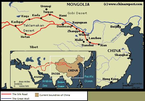
A schematic geographic Map depicting the main pathway of the Silk Road, connecting China with Central Asia and vice versa. Marked on the Map is the location of Lop Nor Lake, of obvious strategic importance in historic terms.
LOP NOR IN THE EARLY 20TH CENTURY - ADVENTURE AND ARCHEOLOGICAL DISCOVERIES :
Many centuries later, the name of Lop Nor once again rose to prominence as the result of extensive and often uninvited explorations of the wider regions, as well as the Silk Road monuments, mainly by European explorers.
During the 19Th Century and early 20th century, several now famous explorers made their name by making their discoveries in what today is Xinjiang-Uighur Autonomous Region, the Taklamakan Desert and around the Lop Nor Lake. The earliest arriving explorers were the Russians, who sent at least five exploring missions in succession and left extensive and acurate (military type) maps which later helped prepare for what amounted to a Russian Invasion. Later arriving European explorers who traversed the Xinjiang Region (New territories ; also East Turkestan) were British and Americans who, apart from recording the geographical features of the local terrain went on the search for ancient and historic cultural relics. The volume of information left after the work of these several waves of explorers concerning the Lop Nor is clearly to large to sum up in this text, however it may be noted that through their works the name of Lop Nor was communicated around the Globe. Especially the reports of Swedish Explorer Sven Hedin, who - against impossible odds and on the verge of a thirsty death- relocated and rediscovered the Lake in 1900 AD, finding it nearly dried out, did much to inspire public imagination around the Globe. Although mass tourism was invented and fully developed only half a century later, it was from that moment that the remote Lop Nor became a worthy historic location and thus a site of tourist interest. It still is today, regardless of its state.
Further historic archeological finds done along the trajectory of the Silk Road near Lop Nor by Sven Hedin, Sir Marcus Aurel Stein and less famous others have further inspired many around the globe. Names of locations such as the Lost City of Miran - refound by Sven Hedin along the rim of empty Lop Nor, and the forgotten Buddhist Kingdom of Loulan from which Aurel Stein took away priceless relics that later proved to have recorded major historical events that occured along the Silk Road have become standard knowledge for Silk Road fans and historians since their first publication.
For a brief two or so decades the Lop Nor was a site if international fame that inspired many around the world to dreams of untold adventure and perhaps Discovery.
The series of already impressive finds initiated by the likes of men such as Sven Hedin and Sir Marcus Aurel Stein culminated into what much later proved to be an absolute highpoint in the year 1934 AD, when the Swedish explorer Folke Bergman was led to previously unsurveyed historical site of modest appearance but at the time unimaginable importance. The site had been discovered in the year 1910 by a Uighur Man named Ördek who had been attached to an exploration team assembled by famed Silk Road explorer Sven Hedin, but was otherwise yet unknown and remained unexplored.
What Bergman found is today know as the Xiaohe (Little River Bronze Age historic site, which is situated within the confines of the Lop Nor Basin.
As described by Bergman in his reports on the extensive measurements and excavations undertaken at and near the site in 1934, it was close to a river bed, which Bergman named Xiaohe, or “Small River.” Once at the location Bergman found what was evidently a very ancient and primitive settlement which had nearby an extensive cemetary of a multitude of Tombs. The cemetary site was found on a hill and was marked by circular arrangements of wooden poles which could clearly be identified from some distance as an unnatural, manmade arrangement.
Although not immediate clear at the time, it was a find of huge historical value. As was proven overtime, the Xiaohe site contained no less than 167 very well preserved bodies of ancient diseased, as well as their clothing and other items. It was and remains the largest concentration of ancient mummies found anywhere in the world. Furthermore, at other locations surrounding the original Xiaohe cemetary location, many other mummies were found, altogether revealing the existance of a bronze age civilization, which thrived at the Lop Nor and in the Tarim River basin as early as 2000 to 1800 B.C., a date that lies well before the official opening date of what today is understood as the Silk Road (138 B.C.) by envoys of the Chinese Han Dynasty (206 BC - 220 AD).
Although today known as an astonishing find, after the initial exhilaration of the Xiaohe bronze age remnants and the grand announcement to a mainly scientific world, nothing much came of the further archeological explorations at Xiaohe in the following decades. To be exact, although scientific explorations had rebegun in the Tarim River Basin in the late 1980's and 1990's, the Xiaohe site itself was only rediscovered in the year 2000 after Chinese translations of Folke Bergman's book on this important location had become available in the year 1997, inspiring scientist to have another look.
Full Google Map of 'unusual facility' (Part of Malan Base) in Lop Nor Bed of Xinjiang AR.
This page was last updated on: May 30, 2017
My Great Web page
Since the first nuclear detonation in 1964 AD, many more Chinese nuclear test followed, mostly at Lop Nor and adjoining regions of Xinjiang until the unilateral compliance of China (P.R.C.) with the nuclear test ban treaty ratified in 1996 AD).
Although the Cold War, Mao Zedong's tyranny and the days of absolute secrecy are long over and some of the secret sites of National Security have even been opened as tourist attractions, much of the Lop Nor desert remains off limits, meaning that they are considered a restricted military zone, and a number of unidentified military facilities remain in this area. Together the most prominent of these are known internationally as the Malan Secret Nuclear Testing Facility.
For decades there have been reports livestock and people suffering from radiation sickness in the vicinity of Lop Nor and in Northern Tibet. Many trees in the lop nor region have lost their leaves and bark. Residents complain of losing their hair and suffering from skin diseases. There have been increases in rates leukemia, throat cancer, miscarriage, premature births and deformed babies. Inside the very large area of Malan, one of the nuclear testing grounds where nuclear devices were tested is situated less than 10 kilometers from a variety of rural type villages inhabited by ethnic Hui, Uighurs and Mongols. It is also rumored that nuclear waste has been dumped in the desert of Lop Nor, as well as in other locations in Xinjiang and neighboring Qinghai Province
Subsequent teams of explorers, archeologist, historians and others have since been able to find many more bronze age tombs and mummies, slowly deducing the image of an ancient Civilization that existed long before the opening of the historic silk road. As historians hold it today, the settlement and the associated cemetery belonged to the Gumugou culture, also known as the Qäwrighul culture, which itself was part of a larger civilization which had lived surrounding the Lop Nor lake and along the rivers of the Tarim River Basin (and what is not Taklamakan desert). Another “beauty” found in the region, a mummy known as the “Beauty of Loulan,” also belonged to this culture. Various other stunning finds have been made recently at Loulan, Yingpan, Cherchen and other locations in the vicinity of Lop Nor, proving that as early as 2000 B.C. (when early Greek Civilization developed) a European type of peoples had been arriving from the far West (Iran, Iraq (Mesopotamia), the Black Sea and Turkey) traveling through Central Asia to the large Tarim River Basin fed by glacial rivers. There, they encountered Asian peoples with whom they intermarried and eventually build a Civilization with. As if all of this was not shocking enough, these peoples knew a primitive art of bronze working which is an art that was previously thought to have been developed in China independently from other parts of the ancient world. As historians now hold it, it is quite possible, if not increasingly likely that the migrations that occured on the Eurasian continent in the millennia before the birth of Christ and the advent of the Silk Road have carried the ancient knowledge of bronze working into China at that time. One of the routes through
YouTube Video: Indo-European mummies in central Asia and China , the story that emerged since the Xiaho Cemetery discovery.
which this knowledge must have traveled is the Tarim River Basin, which sort of establishes a ”silk road of culture and knowledge” in existence long before the opening of the historic Silk Road as dated by the Han Dynasty scribes to the year 138 BC.
Xinjiang-Uygur Autonomous Region Satellite Map 1A
A Satellite Image overview Map of Xinjiang-Uygur Autonomous Region entire and parts of neighboring Nations of India, Pakistan, Afghanistan, Tajikistan, Kyrgyzstan and Kazakhstan, The Tuva-, Khakassia- and Buryatia Republic of the Russian Federation, The Republic of Mongolia, as well as Chinese Provinces and Territories of Gansu Province, Qinghai Province and Tibet Autonomous Region.
This Map Includes Cities and Towns (shown by size), the Irtush River Valley, the Dzungarian Basin of Xinjiang AR, the Taklamakan Desert in South-Central Xinjiang AR, a variety of border passes in the Karakoram Mountain Range and the Tian Shan Mt. Range, plus main waterways, rivers and lakes of this large region.
among whom some who became famous and sometimes left records of its existance and the life of the people and civilization(s) that grew and fell along its shorelines.
To name but a few, the famous Monk Xuanzhang (629 AD - 645 AD) who brought Buddhist knowledge from India, thus becoming the Chief Religious Teacher (Shi Fu) at the famous Great Goose Pagoda in Xi'an (Chang'An), a renowned Chinese Cultural attraction in itself, camped along the shoreline of the Lop Nor. As did several centuries later the now well-known European traveler Marco Polo. Both travelers who left thrilling accounts of their journey, in which particular attention was given to the perilous treck across what by then was already known as an especially barren region. As a result, the name of Lop Nor resounded far beyond merely the regions, or China alone.
As may be deduced from the above explanations, originally, when the first humans settled in the Tarim Basin and found Lop Nor, it was a giant inland sea. This Sea sustained life of generations of people who lived long before the opening of the Silk Road, gradually spawning sophisticated Civilizations over time. For millenia the Tarim Basin and within it the Lop Nor were a lush green zone, with a comforting climate and abundant resources to sustain life and more. However, as time went by the climating conditions slowly changed, slowly shrinking the abundance into smaller and smaller lakes and interspersed Oasis.
This last situation was already more or less what the Han Dynasty (206 BC - 220 AD) found when they first started to open route out of China in the year 138 BC, and it would be
Tarim River Basin
(& Taklamakan Desert)
EARLIEST RECORDED HISTORY OF LOP NOR - THE HAN DYNASTY:
To begin at what was previously thought to be the beginning, during the Han Dynasty Era the Lop Nor was found and recorded by the Han Dynasty (206 BC - 220 AD) envoys on their earliest travels from their Imperial Capital Chang' An (Xi'An) to the west. As a part of the prime discoveries of the Han in the far West, mention of the Lop Lake made it into the Houhanji (后汉纪), an important historical record better known as the (later) Han Dynasty Annals. The Houhanji is a book covering historic events between 20 BC and the fall of the Han Dynasty in the year 220 AD, and it records the Lop Nor as a collection of salty marshes. The Notes on Lop Nor can be found in the 96Th Volume, further giving evidence of the town/city of Shen-Shen (Lou-Lan), situated as we know along the edge of the Lop Lake (later travelers also called the Loulan settlement Lop).
The Han Dynasty Annals thus accurately record historic events that passed between the Han and the Shen-Shen people, describing affairs down to the point of the Kingdom becoming a dependency of Han Dynasty China, in around the year 80 B.C.
what most silk road travelers that followed in the next 2000 would grow accustomed to and deal with.
THE LOP NOR OF THE TANG DYNASTY (618 AD - 907 AD):
Again some Centuries later, when another powerful Dynasty, the Tang (618 AD - 907 AD), propelled China into another episode of greatness, many more developments happened along the pathway of the Silk Road. Where the Tang Dynasty Empire, at its largest, reached far beond even the Tarim River Basin and as far as the southern and eastern shores of the Caspian Sea, the Lop Nor became solidified as a location of obvious military importance and as such permanent military encampments were lodged around it waters.
Although at the time, the population of these regions was very sparse and life depended on but a flimsy string of far between points of human inhabitation, the Lop Nor itself was fairly well defended against an invasion by Foreign peoples (mainly nomadic peoples from Central Asia).
Remnants of fire-beacons in the regions due East of the former Lop Lake, as well as the existance of remnants of the earliest Great wall of China built by the Tang Dynasty Armies in regions between Lop Nor and Dunhuang still prove the importance of the Lop Lake during this Era of economical, scientific and cultural blossoming.
It was in this era that the Monk Xuanzhang traveled out of Dunhuang and on to Lop Nor leaving descriptions of the town of Dunhuang, the Yumen (Jade Gate) through which he left the safety of the Chinese Empire and also the Lop or desert. Others recorded the coming and going of weary travelers through the Yang Guan (Sun Gate) near Dunhuang, the last civilized point before entering the Lop Nor wastelands from the East.
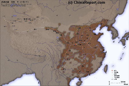
A Map of China as it was during the highpoint of the Tang Dynasty (618 AD - 907 AD) clearly showing the Lop Nor as a large watermass in the East of the Tarim Basin. The Great Wall of China defenses as maintained during the Tang Dynasty halted at the same point as they did during the Han Era, due East of Lop Nor at the Yang Guan (Sun Gate) and Yu Men (Jade Gate), thus laying the borders of the Chinese heartlands (seen in Yellow) outside of Dunhuang, at the very eastern edge of the Lop Nor desert. Today, this is still the border between Gansu Province of China and the adjacent Xinjiang-Uighur Autonomous Region.
LOP NOR AND MARC POLO:
When in turn, during the early 13Th Century, Marco Polo followed the Silk Road, arriving from the West into the Tarim River Basin, the Lop Nor was found by him in much the same condition as it had been for centuries before, a lake within otherwise deserted and waterless regions.
impregnable wall at that early time.
Confirmed by many historic remains found in the regions, historians now agree that there must have been a string of fire beacons leading out to the edge of the Lop Nor and surrounding deserts. Likely, the end beacon at the edge of the desert served as a guiding lights which the weary travelers could follow to succesfully navigate their way and find their exit from the abyss. As Fa Xian records it: ″...We journeyed on and reached Tun-huang (Dunhuang) at the end of the Great Wall, where the frontier is held by the military for a distance of eighty le from east to west, and forty le from north to south (one li---is one-third of a mile). Having stayed there for more than a month, the governor of Tun-huang provided us with all the necessary provisions for crossing the desert.
Subsequently Fa Xian describes his further journey: ″ .. We than traveled on with an envoy of a camel train...″ , leaving his impression of the eery Lop desert as; ″In this desert there are great many evil spirits and hot winds; those who encounter them perish to a man. There are neither birds above nor beasts below. Gazing on all sides as far as the eye can reach in order to mark the track, no guidance is to be obtained save from the rotting bones of dead men, which point the way.″.
And Faxian knew what he was talking about. He himself had found himself, lost without directions among some of the wildest landscapes found in China today (Famous are for instance, the Yadan landforms, reachable from Dunhuang). In the continued tale of his adventure Fa Xian further
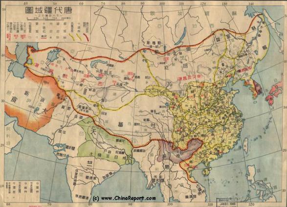
An overview Map of the Han Dynasty Empire (China)(206 BC - 220 AD), as it was at its largest. Clearly the western regions of the Empire extend like a neck from the body of the Empire. This is the hexi corridor, at the end of which lies Dunhuang. Beyond is the Lop Nor and Desert, the first stage of the Silk Road outside of China proper.
- CLICK MAP TO GO TO FULL VERSION -
describes geographic features along the route of his wanderings. Leaving a first reasonably accurate and useful account of the Lop Nor Desert.
Faxian also accounts of the City of Lou-Lan, the next intended stop over on his long journey, which was situated at the Lop Nor lake edge and known as Shen-Shen at the time.
Of Loulan he wrote: ″This is a land rugged and hilly, with a thin and barren soil″. Furthermore, ″The king of this country has received the Faith (I.e. Buddhism), and there are some four thousand and more priests, all belonging to the Lesser Vehicle (=Hiniyana Buddhism or Theravada), but all practice the religion of India (Buddhism)″. Through these words Faxian recorded the Kingdom of Loulan as the first Buddhist State in human history.
Interested as he was in matters of the Buddhist Faith, and exhausted from his near deadly journey through the Lop Nor Desert, Faxian then ended up staying at Lou-Lan for a full month, giving him ample time to make a study of the peoples and record some of their lifestyles.
Apparently the looks of the local people reflected some of this harsh landscape as Faxian told; ″The clothes of the common people are coarse, and like those worn in our land of Han, some wearing felt and others coarse serge or cloth of hair″. In other words in the eyes of Faxian, a foreigner in these parts, there was litle difference between one or the other Loulan citizen; the people of Loulan were rather a drab bunch to him, with meager clothing in dull and coarse colors. It was clearly not the best or richest place had had ever visited. These people were nothing much more than a bunch of peasants.
Being a Monk on a holy mision, the rest of Faxian's accounts mainly deal with the religious state of the people and the Kingdom of Loulan. About these affairs he left us the following cryptic words; ″The common people of this and other kingdoms (in that region), as well as the sramans [monks], all practise the rules of India (Buddhism), only that the latter do so more exactly, and the former more loosely. So (the travellers) found it in all the kingdoms through which they went on their way from this to the west, only that each had its own peculiar barbarous speech.
(The monks), however, who had (given up the worldly life) and quitted their families, were all students of Indian books and the Indian language″.
Clearly Buddhism was well established at this time along the whole route of the Silk Road within the Tarim River Basin, and a variety of different peoples. It also appears, at least to a modern reader, as if Faxian felt quite a bit superior to these rather downtrodden and primitive peoples.
Although nothing much more was left recorded about the Lake in these periods, from archeological evidence found since, it has become clear that the Lake, although situated in utterly barren regions, already functioned as a strategic location along this route, serving as a watersource and recovery point for animal and man alike. Exotic coins, of Indian, Greek and even Roman origin were found exposed in the desert, along with many artifacts, mummified, remains and other items bearing witness to the steady traffic that crossed the regions regardless of the many dangers involved. (On the other hand, life expectancy was short for most humans, and life at home not necessarily safe or healthy)
Map of the Gobi Desert & Yellow River Flow
Satellite Image Map of the Gobi Desert Region. Map overviews North-West Xinjiang Autonomous Region, Mongolia, Inner Mongolia and North and North-Eastern China giving a Full Overview of the Gobi Deserts and Yellow River Basin. Map includes location of LuoYang in Henan and other Cities (clearly visible).
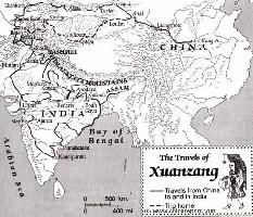
Route Map of Xuanzang's "Journey to The West" (India). As shown, the route out of China leads through Dunhuang to Loulan, a buddhist City along the edge of the Lop Lake.
Of the Lop Nor Xuanzhang accounted: ″Many people have lost their way here in this vast plain which stretches as far as the eye can see. There are no roads. Where-ever you look you can see skeletons of humans mark the way. Because there is no water, nothing can grow here. Further on he remarks: ″.. And when the fiery wind blows here (as it does frequently) one is immediatly struck by sickness, adding that sometimes strange and scary sounds can be heard from across the desert, but when one follows the sound, one easily gets lost″, as Xuanzhang would believe, ″tricked by evil demons″ and so doomed to perish in thirst.
Eventhough it was one of the deadliest parts of the many waterless stretches found within the Tarim River, further archeological finds made at the Lop Nor Lake and the routes leading to it show an abundance of evidence of travel, trade and exchange of culture,
Not many centuries later, when the Han Dynasty had fallen but nevertheless the first ″roads″ through the western regions had been explored and remeined established, the Lop Nor and regions return in the Chinese records and it seems that at that time already the lake (or lakes), situated along the shortest route to the Tarim River and the West, were often used as a stop over point on travels back and forth through the regions.
Another historic record was left in the 4th Century A.D. when one of the first of the now famous Silk Road travelers, the Monk Fa Hsien (Faxian , 法显) (337 AD - 422 AD) wrote of the arduous and thus memorable journey across the wastes of the Lop Nor desert in the year 399 AD. In his words it was an extraordinary place, more deserted than any of the other deserts found along the Silk Route. His first mention is of the town of Dunhuang (also known as Shazou), which was at the time the last large Oasis Town (and administrative center) to be found before entering the western deserts. As can be told from Faxian's accounts, at that time there was already a defensive system in place at the edge of this lost place, the Lop Nor desert. It was a modest beginning of a first Great Wall of China in these far flung western border regions, although there certainly was no continuous and totally
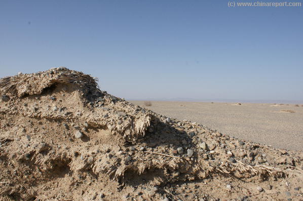
The remains of a Fire-Beacon Tower and adjoining wall made out of rammed earth situated on the western outskirts of Dunhuang. (Photo November 2007).
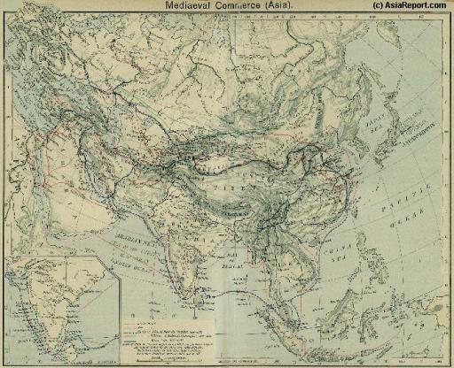
Asia Report - Map Trade Routes in Asia in the 13Th Century
A Schematic Map of the Eurasian Trade Routes existing in the 13Th Century. Clearly marked in Red Accent on the Map are the cities of the network of land-bound trading routes through Central Asia known as the Silk Road (the path of Marco Polo and others). Marked in Blue Accent are the Main Ports and Harbors of the Maritime Trade Routes that operated between the Arabian Peninsula and the Red Sea, the Indian Ocean and Coastal Cities, the Straights of Malacca, the South-China Sea's and beyond. As shown Maritime Trade to China mainly entered through Southern Harbors, then was distributed internally by use of the Grand Canal, the Yangtse River and the Yellow River.
Map includes the Route travelled by Marco Polo, William of Rubruck and John of Pian de Carpine, the three famed European Travelers of the Time.
Locations of Main Trading Ports and Cities on Trade Routes of the Time are marked.
As the writings of Marco Polo show, in the 13Th Century the Lop Nor was still a very large lake, alongside of which lived a variety of people. There were many cities and several Oasis in the Tarim River basin, and in the eastern parts of it the Lop Nor was the most important and prominent watermass. Loulan was the name of the civilization center found along the rim of the Lake, and this city was a place where according to Marco Polo the Camel caravans usually pauzed for a week before attempting the crossing of the Lop Nor Desert. As experienced by previous travelers, Marco Polo found that beyond the lake lay a perilous gap, the featureless Lop Nor Desert. In his writings Marco Polo could whole-heartedly agree with the Monk Xuanzhang who had recorded that; ″there was nothing but mountains (red: in the distance), depressions and sand″.
As Marco would experience, the treck across this vast expanse alone could take up to a month, taking everything man and animal could give. As further recorded by Marco Polo, although featureless, the desert was not entirely devout of water. In fact, according to analysts of the Marco Polo history, Marco Polo mentioned that there were 28 water sources, wells or Oasis, to be found in the stretch between Loulan and Dunhuang (named Saciu - Shazou in the time of Marco Polo).
In his further accounts of the expierince of a treck across the Lop Nor desert, Marco Polo too accounts of how easy it is to become lost and dwell around without direction for days. Other descriptions by Marco Polo echo some of the experiences described Xuanzhang, who indeed was hopelessly lost in the desert for weeks.
During the daytime the travelers suffered from terrible sandstorms, ″the black cloud″ which suddenly descended, or were often attacked by bands of robbers carrying speers and swords. The night time however, seems to have been equally distressing. Marco Polo mentions, as did the Monk Faxian, strange sounds, moaning or voices heard from the desert, mostly at night.
In modern times some have interpreted the nightly lights (supposedly) visible at Lop Nor, the moaning sounds and other strange phenomena described by ancient travelers as proof of ″Alien (.e. extra-terrestrial) Activity″. There are some who have described seeing U.F.O.'s traveling at high speed in the atmosphere or experiencing other oddities. The
Eroded remnants of the first Han Dynasty Era Great Wall of China, some 2000 years old, guard the gravely nothingness of the Lop Nor Desert. Beyond no recognizable landmarks can be seen anyhwere near or on the horizon. Location: Eastern edge of the Lop Nor Desert several kilometers beyond YuMen (Jade Gate). (Photo: November 2007)
science and idea's through the Lop Nor Basin.
Source DVD
"Great Explosions in the East - The Story of Two Bombs & One Satellite"
( available from our Online Store )
Today the Xiaohe site is recognized as a site of important national cultural heritage and it is thus protected under the highest national law. Although famous, due to the inaccessibility of the wider regions, enormous distances of travel, and extreme climate the Xiaohe site is however hardly to be regarded as a tourism site.
Far from it.
The only worthwhile monument to be seen at the site is the now largely excavated group of burial tombs in the desert. It has been named the “Ördek’s necropolis,” after the Uighur guide by that name who had originally discovered the site in 1910 AD.
Much owing to its extremely remote location, and furthermore a long period of political instability in China, little is known about the Lop Nor during the first half of the 20Th Century. What is clear is that the Lake Lop, although found refilled in the year 1910 AD after an unusually wet season, again lost its waters thereafter. Still, in the year 1928 AD the
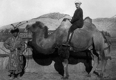
Arguably the Greatest of all Silk Road explorers, Sven Hedin, sitting on a Camel, as photographed during one of Hedin's expeditions in the Tarim River Basin.
Lop Nor Lake water mass was still measured to have a surface area of 3,100 km2 (1,200 sq mi). Even in the years 1934/1935 AD, when above mentioned Swedish explorer Folke Bergman (1902 AD - 1946 AD) traversed the regions discovering what is now known as the Xiaohe Tomb complex, he recorded the Lake (in his maps) as of substantial size. Bergman did find that the lake retreated to quite some distance to the west of the Loulan Ruins, which has historically been situated along the Lake Shore.
wildest opinions are even convinced that there is an underground U.F.O base situated in the Tarim Basin, perhaps at the Lop Nor. It is however unclear how much, if any, substance there is to these old reports. Given the recent history of frequent nuclear test at Lop Nor, and the current status as a highly secure military facility such would seem wild and unliky. Other explanations for recent sightings seem much more plausible.
Map of the Gobi Desert & Yellow River Flow
Satellite Image Map of the Gobi Desert Region. Map overviews North-West Xinjiang Autonomous Region, Mongolia, Inner Mongolia and North and North-Eastern China giving a Full Overview of the Gobi Deserts and Yellow River Basin. Map includes location of LuoYang in Henan and other Cities (clearly visible).